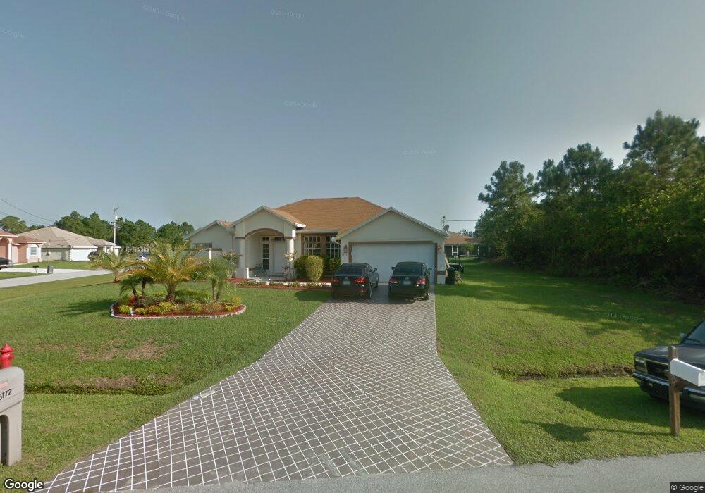
6172 NW East Deville Cir Port Saint Lucie, FL 34986
Torino NeighborhoodEstimated Value: $414,000 - $464,000
3
Beds
2
Baths
1,890
Sq Ft
$231/Sq Ft
Est. Value
About This Home
This home is located at 6172 NW East Deville Cir, Port Saint Lucie, FL 34986 and is currently estimated at $436,343, approximately $230 per square foot. 6172 NW East Deville Cir is a home located in St. Lucie County with nearby schools including West Gate K-8 School, Oak Hammock K-8 School, and Bayshore Elementary School.
Ownership History
Date
Name
Owned For
Owner Type
Purchase Details
Closed on
Mar 21, 2008
Sold by
Deutsche Bank National Trust Co
Bought by
Washington Jessie and Washington Brandy
Current Estimated Value
Home Financials for this Owner
Home Financials are based on the most recent Mortgage that was taken out on this home.
Original Mortgage
$200,726
Outstanding Balance
$126,585
Interest Rate
5.97%
Mortgage Type
FHA
Estimated Equity
$309,758
Purchase Details
Closed on
Sep 19, 2007
Sold by
Lewter Harold D
Bought by
Deutsche Bank National Trust Co
Purchase Details
Closed on
Dec 7, 2000
Sold by
Deyoung Cornelius and Deyoung Catherine
Bought by
Lewter Harold
Home Financials for this Owner
Home Financials are based on the most recent Mortgage that was taken out on this home.
Original Mortgage
$118,300
Interest Rate
7.75%
Purchase Details
Closed on
May 19, 1999
Sold by
Kauffman Ronald P
Bought by
Deyoung Cornelius and Deyoung Catherine
Create a Home Valuation Report for This Property
The Home Valuation Report is an in-depth analysis detailing your home's value as well as a comparison with similar homes in the area
Home Values in the Area
Average Home Value in this Area
Purchase History
| Date | Buyer | Sale Price | Title Company |
|---|---|---|---|
| Washington Jessie | $206,000 | Lsc Title Inc | |
| Deutsche Bank National Trust Co | -- | None Available | |
| Lewter Harold | $10,500 | -- | |
| Deyoung Cornelius | $8,000 | -- |
Source: Public Records
Mortgage History
| Date | Status | Borrower | Loan Amount |
|---|---|---|---|
| Open | Washington Jessie | $200,726 | |
| Previous Owner | Lewter Harold | $118,300 |
Source: Public Records
Tax History Compared to Growth
Tax History
| Year | Tax Paid | Tax Assessment Tax Assessment Total Assessment is a certain percentage of the fair market value that is determined by local assessors to be the total taxable value of land and additions on the property. | Land | Improvement |
|---|---|---|---|---|
| 2024 | $2,797 | $142,090 | -- | -- |
| 2023 | $2,797 | $137,952 | $0 | $0 |
| 2022 | $2,653 | $133,352 | $0 | $0 |
| 2021 | $2,438 | $124,420 | $0 | $0 |
| 2020 | $2,443 | $122,703 | $0 | $0 |
| 2019 | $2,412 | $119,945 | $0 | $0 |
| 2018 | $2,286 | $117,709 | $0 | $0 |
| 2017 | $2,255 | $187,500 | $45,400 | $142,100 |
| 2016 | $2,219 | $188,500 | $33,400 | $155,100 |
| 2015 | $2,237 | $151,500 | $24,800 | $126,700 |
| 2014 | $2,131 | $111,243 | $0 | $0 |
Source: Public Records
Map
Nearby Homes
- 6121 NW Daroco Terrace
- 6116 NW Daroco Terrace
- 6049 NW Winfield Dr
- 6148 NW Densaw Terrace
- 6215 NW West Deville Cir
- 5853 NW Culebra Ave
- 5909 NW Bayou Ct
- 5910 NW Bayou Ct
- 6029 NW Winfield Dr
- 6457 NW Favian Ct
- 5928 NW Wesley Rd
- 6135 NW Densaw Terrace
- 6127 NW Drophy Ave
- 5664 NW Whitecap Rd
- 5745 NW Wesley Rd
- 6018 NW Winfield Dr
- 5901 NW Wolverine Rd
- 6157 NW Gatun Dr
- 6171 NW Gatun Dr
- 6116 NW Densaw Terrace
- 6170 NW East Deville Cir
- 6130 NW Daroco Terrace
- 0 NW East Deville Cir
- 6186 NW East Deville Cir
- 6128 NW Daroco Terrace
- 6173 NW Deville Cir
- 6168 NW East Deville Cir
- 6134 NW Durian St
- 6173 NW East Deville Cir
- 6132 NW Durian St
- 6173 E Deville Cir
- 6175 NW East Deville Cir
- 6171 NW East Deville Cir
- 6177 NW East Deville Cir
- 6130 NW Durian St
- 6180 NW East Deville Cir
- 6166 NW East Deville Cir
- 6169 NW East Deville Cir
- 6167 NW East Deville Cir
- 6129 NW Durian St