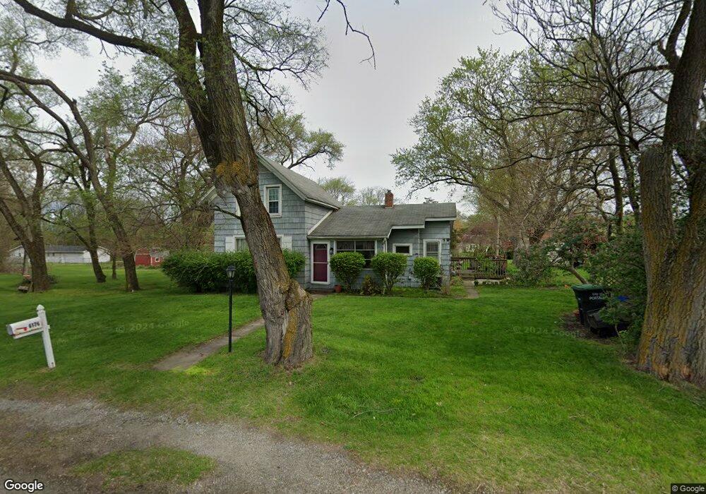
6176 Portage Ave Portage, IN 46368
Estimated Value: $212,000 - $279,000
4
Beds
2
Baths
1,735
Sq Ft
$139/Sq Ft
Est. Value
About This Home
This home is located at 6176 Portage Ave, Portage, IN 46368 and is currently estimated at $240,833, approximately $138 per square foot. 6176 Portage Ave is a home located in Porter County with nearby schools including Crisman Elementary School, Willowcreek Middle School, and Portage High School.
Ownership History
Date
Name
Owned For
Owner Type
Purchase Details
Closed on
Apr 3, 2009
Sold by
The Secretary Of Veterans Affairs
Bought by
Cherry Michelle M
Current Estimated Value
Home Financials for this Owner
Home Financials are based on the most recent Mortgage that was taken out on this home.
Original Mortgage
$81,700
Interest Rate
4.85%
Mortgage Type
Purchase Money Mortgage
Purchase Details
Closed on
Jun 11, 2008
Sold by
Wells Fargo Bank Na
Bought by
Va
Create a Home Valuation Report for This Property
The Home Valuation Report is an in-depth analysis detailing your home's value as well as a comparison with similar homes in the area
Home Values in the Area
Average Home Value in this Area
Purchase History
| Date | Buyer | Sale Price | Title Company |
|---|---|---|---|
| Cherry Michelle M | -- | First Title Of Indiana Inc | |
| Va | -- | None Available | |
| Wells Fargo Bank Na | $98,706 | None Available |
Source: Public Records
Mortgage History
| Date | Status | Borrower | Loan Amount |
|---|---|---|---|
| Previous Owner | Cherry Michelle M | $81,700 |
Source: Public Records
Tax History Compared to Growth
Tax History
| Year | Tax Paid | Tax Assessment Tax Assessment Total Assessment is a certain percentage of the fair market value that is determined by local assessors to be the total taxable value of land and additions on the property. | Land | Improvement |
|---|---|---|---|---|
| 2024 | $2,740 | $140,700 | $46,300 | $94,400 |
| 2023 | $2,720 | $136,000 | $43,800 | $92,200 |
| 2022 | $2,516 | $125,800 | $43,800 | $82,000 |
| 2021 | $2,334 | $115,700 | $43,800 | $71,900 |
| 2020 | $2,198 | $108,900 | $39,900 | $69,000 |
| 2019 | $2,542 | $126,100 | $39,900 | $86,200 |
| 2018 | $2,472 | $122,600 | $39,900 | $82,700 |
| 2017 | $3,026 | $119,100 | $39,900 | $79,200 |
| 2016 | $2,398 | $118,900 | $40,500 | $78,400 |
| 2014 | $2,438 | $120,900 | $41,400 | $79,500 |
| 2013 | -- | $112,600 | $40,700 | $71,900 |
Source: Public Records
Map
Nearby Homes
- 0 Airport Us 6 Unit NRA806028
- 0 Central Ave Unit NRA826855
- 0 Melton Rd Unit NRA811705
- 0 Airport Us 6 Unit NRA829208
- 6170 Lakewood Ave
- 6184 Lakewood Ave
- 6192 Lakewood Ave
- 6208 Lakewood Ave
- 6195 Lakewood Ave
- 2183 Foley St
- 2230 Foley St
- 2408 Jupiter St
- 2359 Dunewood St
- 2373 Dunewood St
- Rowan Plan at Dunewood Trails - Single Family Homes
- 6227 Dunewood St
- Blakely Plan at Dunewood Trails - Single Family Homes
- 2239 Hamstrom Rd
- 6281 Venus Ave
- 2400 Hamstrom Rd
- 6184 Portage Ave
- 6161 Federal Ave
- 6183 Federal Ave
- 6192 Portage Ave
- 6193 Federal Ave
- 6200 Portage Ave
- 6147 Federal Ave
- 6201 Federal Ave
- 6176 Federal Ave
- 6170 Federal Ave
- 6210 Portage Ave
- 6207 Federal Ave
- 6182 Federal Ave
- 6196 Federal Ave
- 6215 Federal Ave
- 6204 Federal Ave
- 6212 Federal Ave
- 2200 Madison St
- 2217 Madison St
- 2192 Madison St