Estimated Value: $815,000 - $990,000
3
Beds
3
Baths
2,225
Sq Ft
$399/Sq Ft
Est. Value
About This Home
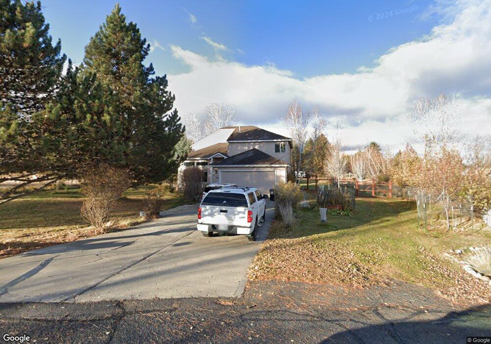
This home is located at 61765 Tomahawk St, Bend, OR 97702 and is currently estimated at $888,487, approximately $399 per square foot. 61765 Tomahawk St is a home located in Deschutes County with nearby schools including Silver Rail Elementary School, High Desert Middle School, and Bend Senior High School.
Ownership History
Date
Name
Owned For
Owner Type
Purchase Details
Closed on
Jan 7, 2011
Sold by
King Robin M
Bought by
Mayer Michael S and Mayer Joan B
Current Estimated Value
Home Financials for this Owner
Home Financials are based on the most recent Mortgage that was taken out on this home.
Original Mortgage
$125,100
Outstanding Balance
$81,721
Interest Rate
4%
Mortgage Type
New Conventional
Estimated Equity
$806,766
Purchase Details
Closed on
Mar 2, 2004
Sold by
Forshee Mel L and Forshee Jyme D
Bought by
King Robin M
Home Financials for this Owner
Home Financials are based on the most recent Mortgage that was taken out on this home.
Original Mortgage
$217,600
Interest Rate
5.65%
Mortgage Type
Unknown
Create a Home Valuation Report for This Property
The Home Valuation Report is an in-depth analysis detailing your home's value as well as a comparison with similar homes in the area
Purchase History
| Date | Buyer | Sale Price | Title Company |
|---|---|---|---|
| Mayer Michael S | $305,000 | First American Title | |
| King Robin M | $256,000 | Amerititle |
Source: Public Records
Mortgage History
| Date | Status | Borrower | Loan Amount |
|---|---|---|---|
| Open | Mayer Michael S | $125,100 | |
| Previous Owner | King Robin M | $217,600 |
Source: Public Records
Tax History
| Year | Tax Paid | Tax Assessment Tax Assessment Total Assessment is a certain percentage of the fair market value that is determined by local assessors to be the total taxable value of land and additions on the property. | Land | Improvement |
|---|---|---|---|---|
| 2025 | $5,430 | $362,490 | -- | -- |
| 2024 | $5,195 | $351,940 | -- | -- |
| 2023 | $4,889 | $341,690 | $0 | $0 |
| 2022 | $4,508 | $322,080 | $0 | $0 |
| 2021 | $4,536 | $312,700 | $0 | $0 |
| 2020 | $4,282 | $312,700 | $0 | $0 |
| 2019 | $4,161 | $303,600 | $0 | $0 |
| 2018 | $4,040 | $294,760 | $0 | $0 |
| 2017 | $3,933 | $286,180 | $0 | $0 |
| 2016 | $3,737 | $277,850 | $0 | $0 |
| 2015 | $3,632 | $269,760 | $0 | $0 |
| 2014 | $3,515 | $261,910 | $0 | $0 |
Source: Public Records
Map
Nearby Homes
- 61747 Somerset Dr
- 61900 Anker Ln
- 21925 Bear Creek Rd
- 21435 Modoc Ln
- 21509 O'Connor Way
- 21507 O'Connor Way
- 61065 NE Unity Place
- 61059 NE Give Place
- 61073 NE Unity Place
- 57 NE Give Place
- 61055 NE Give Place
- 60169 NE Unity Place
- 21549 NE Gather Place
- 21557 NE Gather Place Unit 72
- 21553 NE Gather Place Unit 71
- 61083 NE Give Place Unit 65
- 21517 O'Connor Way
- 21426 Livingston Dr Unit 18
- 21505 O'Connor Way
- 21499O 'Connor Way
- 61755 Tomahawk St
- 61775 Tomahawk St
- 61760 Tomahawk St
- 61774 Tomahawk St
- 61739 Tomahawk St
- 61760 Arrow Ave
- 21714 Obsidian Ave
- 61770 Arrow Ave
- 61767 Wickiup Rd
- 61740 Arrow Ave
- 61780 Arrow Ave
- 61773 Wickiup Rd
- 61801 Wickiup Rd
- 61747 Wickiup Rd
- 61856 Dobbin Rd
- 21758 Obsidian Ave
- 61787 Wickiup Rd
- 21725 Obsidian Ave
- 61858 Dobbin Rd
Your Personal Tour Guide
Ask me questions while you tour the home.