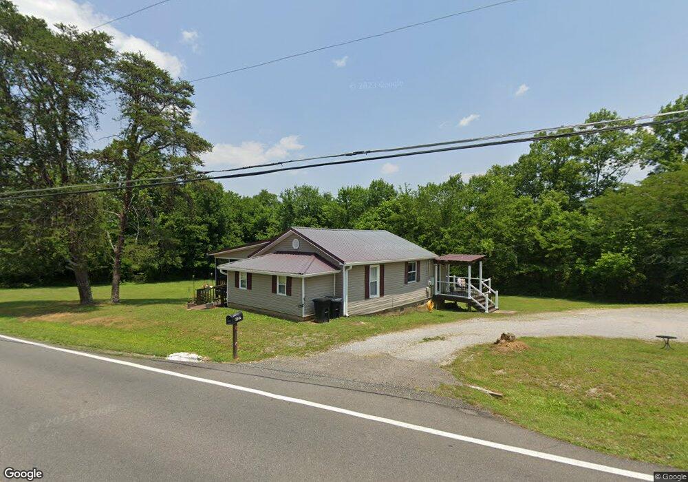
6177 Highway 193 Flintstone, GA 30725
High Point NeighborhoodEstimated Value: $194,237 - $270,000
--
Bed
1
Bath
1,264
Sq Ft
$192/Sq Ft
Est. Value
About This Home
This home is located at 6177 Highway 193, Flintstone, GA 30725 and is currently estimated at $242,309, approximately $191 per square foot. 6177 Highway 193 is a home located in Walker County with nearby schools including Chattanooga Valley Elementary School, Chattanooga Valley Middle School, and Ridgeland High School.
Ownership History
Date
Name
Owned For
Owner Type
Purchase Details
Closed on
Oct 23, 2020
Sold by
Landers Christine P
Bought by
Landers Carolyn Ann
Current Estimated Value
Purchase Details
Closed on
Sep 17, 1979
Sold by
Landers Joyce Ann
Bought by
Landers Louis E and Joyce An
Purchase Details
Closed on
Feb 11, 1972
Sold by
Landers Christine P and Landers Larry
Bought by
Landers Joyce Ann
Purchase Details
Closed on
Jan 1, 1972
Sold by
Landers Louis E and Joyce An
Bought by
Landers Christine P and Landers Larry
Create a Home Valuation Report for This Property
The Home Valuation Report is an in-depth analysis detailing your home's value as well as a comparison with similar homes in the area
Home Values in the Area
Average Home Value in this Area
Purchase History
| Date | Buyer | Sale Price | Title Company |
|---|---|---|---|
| Landers Carolyn Ann | -- | -- | |
| Landers Christine P | -- | -- | |
| Landers Louis E | -- | -- | |
| Landers Joyce Ann | -- | -- | |
| Landers Christine P | $15,000 | -- | |
| Gallaher Bertha | -- | -- |
Source: Public Records
Tax History Compared to Growth
Tax History
| Year | Tax Paid | Tax Assessment Tax Assessment Total Assessment is a certain percentage of the fair market value that is determined by local assessors to be the total taxable value of land and additions on the property. | Land | Improvement |
|---|---|---|---|---|
| 2024 | $1,549 | $69,544 | $12,872 | $56,672 |
| 2023 | $1,483 | $65,023 | $11,493 | $53,530 |
| 2022 | $1,201 | $48,278 | $2,694 | $45,584 |
| 2021 | $968 | $32,755 | $2,694 | $30,061 |
| 2020 | $598 | $25,602 | $2,694 | $22,908 |
| 2019 | $610 | $25,602 | $2,694 | $22,908 |
| 2018 | $677 | $25,602 | $2,694 | $22,908 |
| 2017 | $841 | $25,602 | $2,694 | $22,908 |
| 2016 | $711 | $30,270 | $2,694 | $27,576 |
| 2015 | $691 | $23,542 | $5,472 | $18,070 |
| 2014 | $608 | $23,542 | $5,472 | $18,070 |
| 2013 | -- | $23,541 | $5,472 | $18,069 |
Source: Public Records
Map
Nearby Homes
- 0 Roundtree Ct Unit RTC2914889
- 0 Roundtree Ct Unit 1514898
- 206 Elaine Dr
- 433 Stanford Dr
- 144 N Victor Dr
- 3509 N Highway N 341
- 3509 N Highway 341
- 529 Hidden Oaks Dr
- 2255 Nick-A Jack Rd
- 301 Hidden Oaks Dr
- 1854 Powder Springs Cir
- 675 Mill Wee Hollow Rd
- 1080 Harp Switch Rd
- 12 Mark Cir
- 1010 Harp Switch Rd
- 0 Cloud 9 Ln Unit RTC2915945
- 0 Cloud 9 Ln Unit 1514939
- 19 Turkey Run
- 426 Simmons Tawzer Rd
- 2751 N Highway 341
- 12 Connie Ln
- 6125 Highway 193
- 11 Connie Ln
- 6124 Highway 193
- 6083 Highway 193
- 6242 Highway 193
- 6059 Highway 193
- 6270 Highway 193
- 6270 Hwy 193
- 6270 Georgia 193
- 6057 Highway 193
- 6298 Highway 193
- 6298 Highway 193 Unit 216
- 6298 Hwy 193
- 816 Chattanooga Valley Rd
- 6328 Highway 193
- 5942 Highway 193
- 224 Shirley Ln
- 6330 Highway 193
- 6338 Highway 193