Estimated Value: $309,000 - $353,000
3
Beds
2
Baths
1,612
Sq Ft
$204/Sq Ft
Est. Value
About This Home
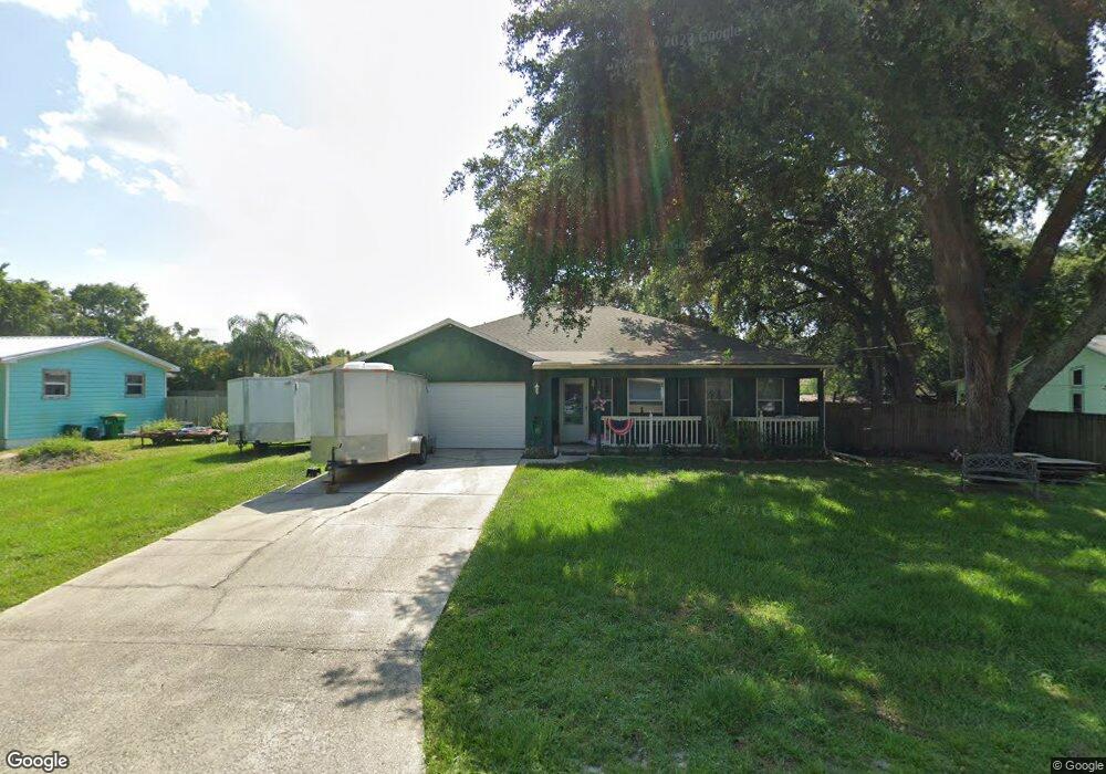
This home is located at 6178 Corning Rd, Cocoa, FL 32927 and is currently estimated at $328,564, approximately $203 per square foot. 6178 Corning Rd is a home located in Brevard County with nearby schools including Enterprise Elementary School, Space Coast Junior/Senior High School, and East Atlantic Prep of Brevard County.
Ownership History
Date
Name
Owned For
Owner Type
Purchase Details
Closed on
Oct 3, 2013
Sold by
Welcome George I
Bought by
Welcome Nicole M
Current Estimated Value
Purchase Details
Closed on
Jul 30, 2004
Sold by
Seberry James Everett and Seberry Thanh T
Bought by
Welcome George L and Welcome Nicole M
Home Financials for this Owner
Home Financials are based on the most recent Mortgage that was taken out on this home.
Original Mortgage
$159,598
Interest Rate
6.22%
Create a Home Valuation Report for This Property
The Home Valuation Report is an in-depth analysis detailing your home's value as well as a comparison with similar homes in the area
Home Values in the Area
Average Home Value in this Area
Purchase History
| Date | Buyer | Sale Price | Title Company |
|---|---|---|---|
| Welcome Nicole M | -- | None Available | |
| Welcome George L | $154,500 | Gulfatlantic Title |
Source: Public Records
Mortgage History
| Date | Status | Borrower | Loan Amount |
|---|---|---|---|
| Previous Owner | Welcome George L | $159,598 |
Source: Public Records
Tax History
| Year | Tax Paid | Tax Assessment Tax Assessment Total Assessment is a certain percentage of the fair market value that is determined by local assessors to be the total taxable value of land and additions on the property. | Land | Improvement |
|---|---|---|---|---|
| 2025 | $1,264 | $90,600 | -- | -- |
| 2024 | $1,227 | $88,050 | -- | -- |
| 2023 | $1,227 | $85,490 | $0 | $0 |
| 2022 | $1,142 | $83,000 | $0 | $0 |
| 2021 | $1,131 | $80,590 | $0 | $0 |
| 2020 | $1,066 | $79,480 | $0 | $0 |
| 2019 | $1,000 | $77,700 | $0 | $0 |
| 2018 | $990 | $76,260 | $0 | $0 |
| 2017 | $980 | $74,700 | $0 | $0 |
| 2016 | $989 | $73,170 | $18,000 | $55,170 |
| 2015 | $1,000 | $72,670 | $15,000 | $57,670 |
| 2014 | $1,004 | $72,100 | $11,000 | $61,100 |
Source: Public Records
Map
Nearby Homes
- 6085 Edison St
- 6150 Baltimore Ave
- 00000 Golfview Ave
- 6230 Balsam St
- 6220 Golfview Ave
- 6180 Balboa St
- 6250 Ainsworth Rd
- 6215 Balboa St
- 23-35-21-JX-B-2 Aruin St
- 6460 Homestead Ave
- 5812 Homestead Ave
- 0 Aruin St Unit 1222557
- 6510 Aspen Ln
- 6460 Ainsworth Rd
- 6545 Addie Ave
- 6135 Allmont St
- 6115 Allmont St
- 6490 Addax Ave
- 5721 Beaverbrook St
- 5680 Banos Ave
Your Personal Tour Guide
Ask me questions while you tour the home.