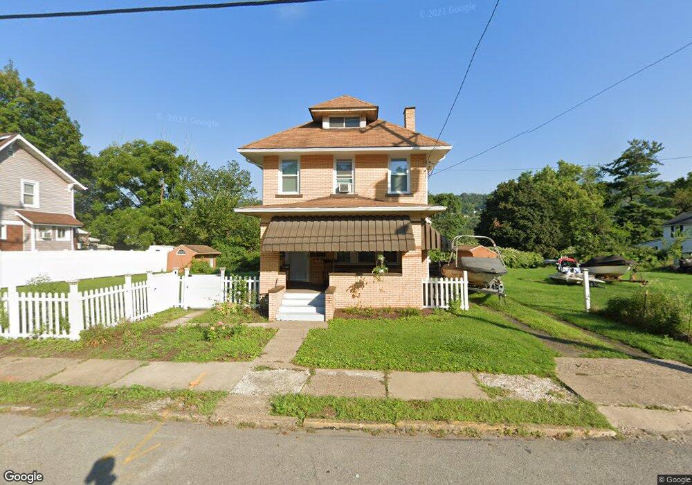
618 Atlantic Ave McKeesport, PA 15132
Estimated Value: $69,000 - $131,000
2
Beds
1
Bath
1,388
Sq Ft
$66/Sq Ft
Est. Value
About This Home
This home is located at 618 Atlantic Ave, McKeesport, PA 15132 and is currently estimated at $91,955, approximately $66 per square foot. 618 Atlantic Ave is a home located in Allegheny County with nearby schools including Mckeesport Area Senior High School, Propel Schools - McKeesport, and Walnut Grove Christian School.
Ownership History
Date
Name
Owned For
Owner Type
Purchase Details
Closed on
Nov 16, 2018
Sold by
Kranack Robert J and Kranack Nancy
Bought by
Morgavo Kassandra
Current Estimated Value
Home Financials for this Owner
Home Financials are based on the most recent Mortgage that was taken out on this home.
Original Mortgage
$82,450
Outstanding Balance
$72,350
Interest Rate
4.7%
Mortgage Type
New Conventional
Estimated Equity
$19,605
Purchase Details
Closed on
Jun 12, 2013
Sold by
Boyle Gerard F
Bought by
Kranack Robert J
Purchase Details
Closed on
Nov 16, 1998
Sold by
Zuccarelli Kenneth M and Zuccarelli Elaine M
Bought by
Boyle Gerard F and Boyle Kathy D
Purchase Details
Closed on
Jan 1, 1900
Create a Home Valuation Report for This Property
The Home Valuation Report is an in-depth analysis detailing your home's value as well as a comparison with similar homes in the area
Home Values in the Area
Average Home Value in this Area
Purchase History
| Date | Buyer | Sale Price | Title Company |
|---|---|---|---|
| Morgavo Kassandra | $85,000 | Barristers Land Abstract | |
| Kranack Robert J | $35,000 | -- | |
| Boyle Gerard F | $50,000 | -- | |
| -- | -- | -- |
Source: Public Records
Mortgage History
| Date | Status | Borrower | Loan Amount |
|---|---|---|---|
| Open | Morgavo Kassandra | $82,450 |
Source: Public Records
Tax History Compared to Growth
Tax History
| Year | Tax Paid | Tax Assessment Tax Assessment Total Assessment is a certain percentage of the fair market value that is determined by local assessors to be the total taxable value of land and additions on the property. | Land | Improvement |
|---|---|---|---|---|
| 2025 | $554 | $12,000 | $4,800 | $7,200 |
| 2024 | $554 | $12,000 | $4,800 | $7,200 |
| 2023 | $554 | $12,000 | $4,800 | $7,200 |
| 2022 | $554 | $12,000 | $4,800 | $7,200 |
| 2021 | $466 | $12,000 | $4,800 | $7,200 |
| 2020 | $545 | $12,000 | $4,800 | $7,200 |
| 2019 | $914 | $30,000 | $4,800 | $25,200 |
| 2018 | $142 | $30,000 | $4,800 | $25,200 |
| 2017 | $832 | $30,000 | $4,800 | $25,200 |
| 2016 | $142 | $30,000 | $4,800 | $25,200 |
| 2015 | $142 | $30,000 | $4,800 | $25,200 |
| 2014 | -- | $30,000 | $4,800 | $25,200 |
Source: Public Records
Map
Nearby Homes
- 622 Atlantic Ave
- 626 Atlantic Ave
- 612 Atlantic Ave
- 623 Atlantic Ave
- 608 Atlantic Ave
- 619 Atlantic Ave
- 619 Atlantic Ave
- 611 Atlantic Ave
- 606 Atlantic Ave
- 625 Atlantic Ave
- 615 Atlantic Ave
- 604 Atlantic Ave
- 612 Gross St
- 607 Atlantic Ave
- 600 Atlantic Ave
- 602 Atlantic Ave
- 602 Atlantic Ave
- 530 Atlantic Ave
- 639 Atlantic Ave
- 608 Pacific St