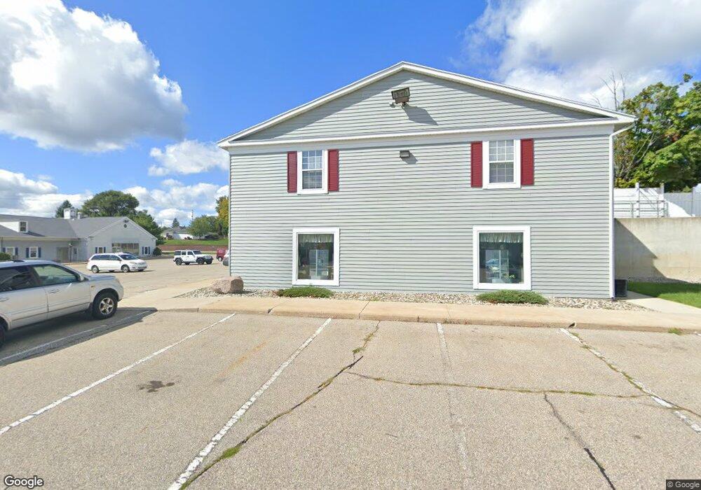
618 Romence Rd Unit 233 Portage, MI 49024
Estimated Value: $5,368,562
--
Bed
--
Bath
15,840
Sq Ft
$339/Sq Ft
Est. Value
About This Home
This home is located at 618 Romence Rd Unit 233, Portage, MI 49024 and is currently estimated at $5,368,562, approximately $338 per square foot. 618 Romence Rd Unit 233 is a home located in Kalamazoo County with nearby schools including Haverhill Elementary School, Portage North Middle School, and Portage Northern High School.
Ownership History
Date
Name
Owned For
Owner Type
Purchase Details
Closed on
Dec 7, 2015
Sold by
Hillside Center
Bought by
Maha Holdings Llc
Current Estimated Value
Home Financials for this Owner
Home Financials are based on the most recent Mortgage that was taken out on this home.
Original Mortgage
$1,610,000
Interest Rate
3.88%
Mortgage Type
Future Advance Clause Open End Mortgage
Create a Home Valuation Report for This Property
The Home Valuation Report is an in-depth analysis detailing your home's value as well as a comparison with similar homes in the area
Home Values in the Area
Average Home Value in this Area
Purchase History
| Date | Buyer | Sale Price | Title Company |
|---|---|---|---|
| Maha Holdings Llc | -- | Chicago Title Company |
Source: Public Records
Mortgage History
| Date | Status | Borrower | Loan Amount |
|---|---|---|---|
| Closed | Maha Holdings Llc | $1,610,000 |
Source: Public Records
Tax History Compared to Growth
Tax History
| Year | Tax Paid | Tax Assessment Tax Assessment Total Assessment is a certain percentage of the fair market value that is determined by local assessors to be the total taxable value of land and additions on the property. | Land | Improvement |
|---|---|---|---|---|
| 2025 | $92,161 | $1,748,800 | $0 | $0 |
| 2024 | $84,233 | $1,782,300 | $0 | $0 |
| 2023 | $80,271 | $1,758,600 | $0 | $0 |
| 2022 | $83,573 | $1,551,300 | $0 | $0 |
| 2021 | $80,095 | $1,270,400 | $0 | $0 |
| 2020 | $79,925 | $1,275,100 | $0 | $0 |
| 2019 | $5,244 | $1,870,100 | $0 | $0 |
| 2018 | $0 | $1,426,800 | $0 | $0 |
| 2017 | $0 | $1,272,900 | $0 | $0 |
| 2016 | -- | $1,205,800 | $0 | $0 |
| 2015 | -- | $943,000 | $0 | $0 |
| 2014 | -- | $936,100 | $0 | $0 |
Source: Public Records
Map
Nearby Homes
- 1010 Romence Rd
- 7090 S Westnedge Ave
- 7243 S Westnedge Ave
- 7313 S Westnedge Ave
- 1524 Greenview Ave
- 6827 Marlow St
- 1328 Edington St
- 223 Schuring Rd
- 6325 Avon St
- 7104 Rockford St
- 520 Della St
- 509 Della St
- 1332 Sussex St
- 6803 Fescue St
- 7403 Rockford St
- 6303 Surrey St
- 6803 Bluegrass St
- 1627 Whitby Ave
- 7117 White Oak Cir
- 6745 Oakland Dr
- 618 Romence Rd Unit 226
- 618 Romence Rd Unit 230
- 618 Romence Rd Unit 213B
- 618 Romence Rd Unit 245
- 618 Romence Rd Unit 123
- 618 Romence Rd Unit 101B
- 618 Romence Rd Unit 216
- 618 Romence Rd Unit 116
- 618 Romence Rd Unit 107
- 618 Romence Rd Unit 111
- 618 Romence Rd Unit 102
- 618 Romence Rd Unit 112
- 618 Romence Rd Unit 240
- 618 Romence Rd Unit 101A
- 618 Romence Rd Unit 250
- 618 Romence Rd Unit 224
- 618 Romence Rd Unit 215
- 618 Romence Rd Unit 104A
- 618 Romence Rd Unit 228
- 618 Romence Rd Unit 225