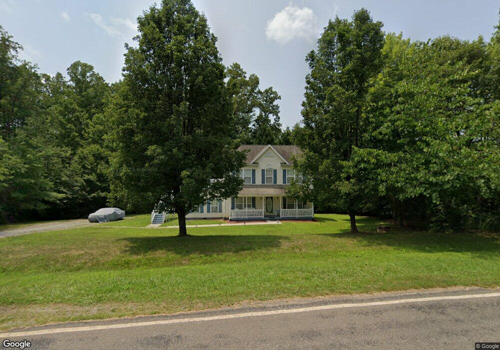
618 Sharp Rd Madison, NC 27025
Estimated Value: $218,000 - $284,000
3
Beds
2
Baths
1,964
Sq Ft
$130/Sq Ft
Est. Value
About This Home
This home is located at 618 Sharp Rd, Madison, NC 27025 and is currently estimated at $255,667, approximately $130 per square foot. 618 Sharp Rd is a home located in Rockingham County with nearby schools including Huntsville Elementary School, John W. Dillard Academy, and Western Rockingham Middle School.
Ownership History
Date
Name
Owned For
Owner Type
Purchase Details
Closed on
Dec 22, 2016
Sold by
Scott R Kelly
Bought by
Hart Kenneth
Current Estimated Value
Home Financials for this Owner
Home Financials are based on the most recent Mortgage that was taken out on this home.
Original Mortgage
$113,000
Outstanding Balance
$93,373
Interest Rate
4.3%
Estimated Equity
$162,294
Create a Home Valuation Report for This Property
The Home Valuation Report is an in-depth analysis detailing your home's value as well as a comparison with similar homes in the area
Purchase History
| Date | Buyer | Sale Price | Title Company |
|---|---|---|---|
| Hart Kenneth | -- | -- |
Source: Public Records
Mortgage History
| Date | Status | Borrower | Loan Amount |
|---|---|---|---|
| Open | Hart Kenneth | $113,000 | |
| Closed | Hart Kenneth | -- |
Source: Public Records
Tax History
| Year | Tax Paid | Tax Assessment Tax Assessment Total Assessment is a certain percentage of the fair market value that is determined by local assessors to be the total taxable value of land and additions on the property. | Land | Improvement |
|---|---|---|---|---|
| 2025 | $1,694 | $243,644 | $21,991 | $221,653 |
| 2024 | $1,620 | $243,644 | $21,991 | $221,653 |
| 2023 | $1,620 | $148,853 | $13,994 | $134,859 |
| 2022 | $1,176 | $148,853 | $13,994 | $134,859 |
| 2021 | $1,176 | $148,853 | $13,994 | $134,859 |
| 2020 | $1,176 | $148,853 | $13,994 | $134,859 |
| 2019 | $1,176 | $148,853 | $13,994 | $134,859 |
| 2018 | $1,145 | $144,754 | $21,995 | $122,759 |
| 2017 | $1,145 | $144,754 | $21,995 | $122,759 |
| 2015 | $1,157 | $144,754 | $21,995 | $122,759 |
| 2014 | -- | $144,754 | $21,995 | $122,759 |
Source: Public Records
Map
Nearby Homes
- 560 Sharp Rd
- 670 Foxwood Rd
- 696 Gold Hill Rd
- 668 Gold Hill Rd
- 219 Sitting Rock Dr
- 154 Sitting Rock Dr
- 228 Sitting Rock Dr
- 221 Fisher Rd
- 1295, 1297 & 1350 Angell Rd
- 220 Farmview Rd
- 460 Gold Hill Rd
- 183 Providence Trail
- 448 Gold Hill Rd
- 184 Providence Trail
- 424 Gold Hill Rd
- 834 Neal Rd
- 626 Bethany Rd
- 0 Griffin Rd
- 110 Levington Way
- 173 Carlton Rd
- 621 Sharp Rd
- 1742 Gold Hill Rd
- 1763 Gold Hill Rd
- 1733 Gold Hill Rd
- 1701 Gold Hill Rd
- 1765 Gold Hill Rd
- 1817 Gold Hill Rd
- 1.7 Gold Hill
- 1820 Gold Hill Rd
- 521 Sharp Rd
- 1682 Gold Hill Rd
- 1843 Gold Hill Rd
- 115 Tonawanda Rd
- 501 Sharp Rd
- 00 Gold Hill Rd
- 1642 Gold Hill Rd
- 165 Tonawanda Rd
- 181 Tonawanda Rd
- 191 Tonawanda Rd
- 1634 Gold Hill Rd
Your Personal Tour Guide
Ask me questions while you tour the home.