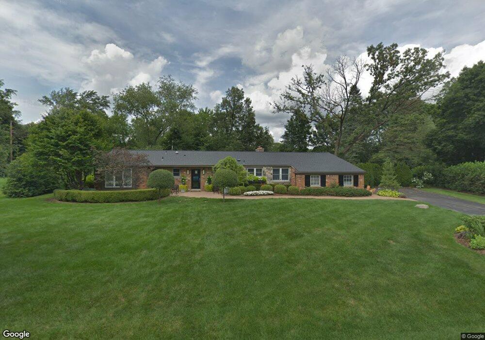
6183 Thorncrest Dr Bloomfield Hills, MI 48301
Estimated Value: $691,000 - $1,022,000
3
Beds
3
Baths
2,251
Sq Ft
$363/Sq Ft
Est. Value
About This Home
This home is located at 6183 Thorncrest Dr, Bloomfield Hills, MI 48301 and is currently estimated at $817,975, approximately $363 per square foot. 6183 Thorncrest Dr is a home located in Oakland County with nearby schools including Conant Elementary School, South Hills Middle School, and Bloomfield Hills High School.
Ownership History
Date
Name
Owned For
Owner Type
Purchase Details
Closed on
Jun 18, 2004
Sold by
Keslar Michael W and Villalobos Maria
Bought by
Laurich Dennis and Laurich Jill
Current Estimated Value
Purchase Details
Closed on
Jun 27, 2002
Sold by
Gillihan Paul W
Bought by
Keslar Michael W
Home Financials for this Owner
Home Financials are based on the most recent Mortgage that was taken out on this home.
Original Mortgage
$396,000
Interest Rate
6.56%
Purchase Details
Closed on
Mar 21, 1996
Sold by
Gillihan Paul W
Bought by
Paul W Gillihan Tr
Create a Home Valuation Report for This Property
The Home Valuation Report is an in-depth analysis detailing your home's value as well as a comparison with similar homes in the area
Home Values in the Area
Average Home Value in this Area
Purchase History
| Date | Buyer | Sale Price | Title Company |
|---|---|---|---|
| Laurich Dennis | -- | Philip R Seaver Title Co Inc | |
| Keslar Michael W | $440,000 | -- | |
| Paul W Gillihan Tr | -- | -- |
Source: Public Records
Mortgage History
| Date | Status | Borrower | Loan Amount |
|---|---|---|---|
| Previous Owner | Keslar Michael W | $396,000 |
Source: Public Records
Tax History Compared to Growth
Tax History
| Year | Tax Paid | Tax Assessment Tax Assessment Total Assessment is a certain percentage of the fair market value that is determined by local assessors to be the total taxable value of land and additions on the property. | Land | Improvement |
|---|---|---|---|---|
| 2024 | $3,079 | $293,850 | $0 | $0 |
| 2023 | $2,748 | $232,590 | $0 | $0 |
| 2022 | $5,857 | $214,350 | $0 | $0 |
| 2021 | $5,827 | $213,120 | $0 | $0 |
| 2020 | $2,513 | $241,140 | $0 | $0 |
| 2019 | $5,578 | $239,510 | $0 | $0 |
| 2018 | $5,608 | $215,480 | $0 | $0 |
| 2017 | $5,498 | $207,680 | $0 | $0 |
| 2016 | $5,534 | $207,180 | $0 | $0 |
| 2015 | -- | $171,130 | $0 | $0 |
| 2014 | -- | $145,580 | $0 | $0 |
| 2011 | -- | $110,060 | $0 | $0 |
Source: Public Records
Map
Nearby Homes
- 6360 Hills Dr
- 5741 Snowshoe Cir
- 6450 Gilbert Lake Rd
- 5630 S Adams Way
- 750 Trailwood Path Unit B
- 450 Billingsgate Ct Unit C
- 1760 Trailwood Path
- 6660 Woodbank Dr
- 5904 Wing Lake Rd
- 3880 Oakland Dr
- 6572 Spruce Dr
- 4017 Hidden Woods Dr
- 6560 Red Maple Ln
- 5825 Lahser Rd
- 3546 Bloomfield Club Dr
- 6580 Red Maple Ln
- 5129 Woodlands Ln
- 5137 Woodlands Dr Unit 24
- 6952 Sandalwood Dr
- 5361 Echo Rd
- 6159 Thorncrest Dr
- 6191 Thorncrest Dr
- 6172 Thorncrest Dr
- 6000 Snowshoe Cir
- 6059 Burnham Ct
- 6148 Thorncrest Dr
- 6135 Thorncrest Dr
- 6040 Burnham Ct
- 6041 Burnham Ct
- 6014 Snowshoe Cir
- 6268 Ramshead Ct
- 6124 Thorncrest Dr
- 6223 Thorncrest Dr
- 6020 Burnham Ct
- 6111 Thorncrest Dr
- 5950 Snowshoe Cir
- 5971 Blandford Rd
- 6288 Hills Dr
- 5991 Blandford Cir
- 6245 Thorncrest Dr