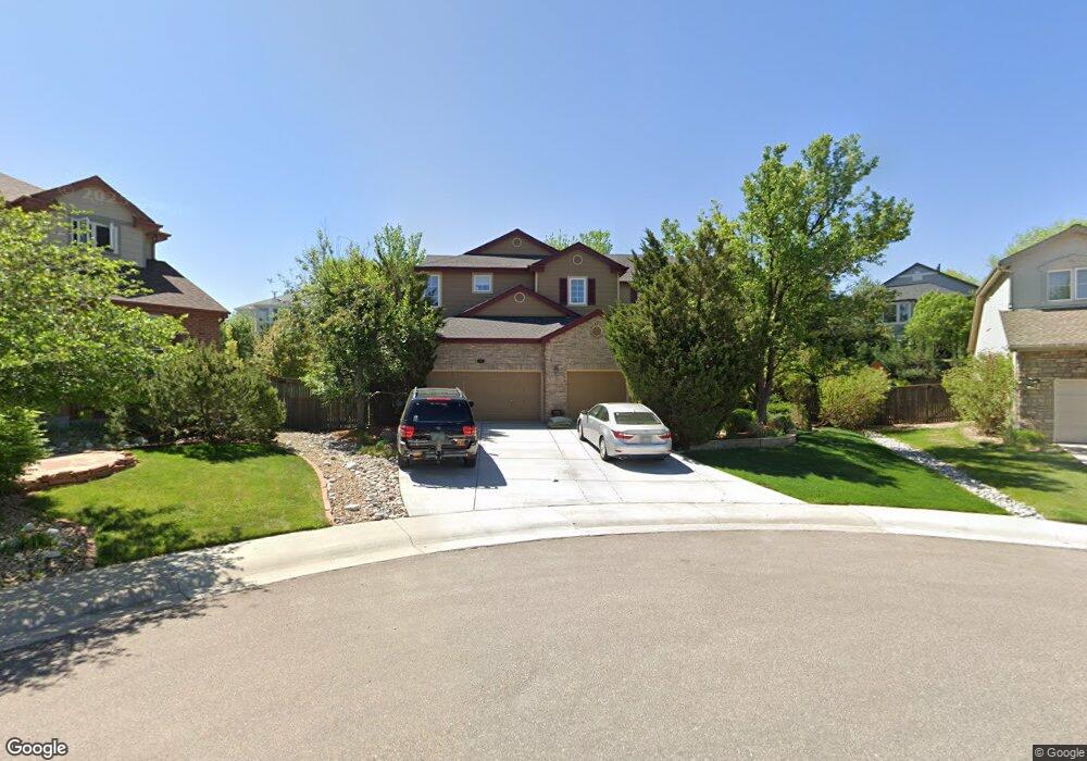
6184 Puma Sands Lone Tree, CO 80124
Southridge NeighborhoodEstimated Value: $620,000 - $1,194,000
4
Beds
4
Baths
3,336
Sq Ft
$295/Sq Ft
Est. Value
About This Home
This home is located at 6184 Puma Sands, Lone Tree, CO 80124 and is currently estimated at $984,901, approximately $295 per square foot. 6184 Puma Sands is a home located in Douglas County with nearby schools including Wildcat Mountain Elementary School, Rocky Heights Middle School, and Rock Canyon High School.
Ownership History
Date
Name
Owned For
Owner Type
Purchase Details
Closed on
Dec 22, 1999
Sold by
Falcon Homes At Wildcat Ridge Llc
Bought by
Keil Jeffrey C and Keil Constance A
Current Estimated Value
Home Financials for this Owner
Home Financials are based on the most recent Mortgage that was taken out on this home.
Original Mortgage
$294,500
Outstanding Balance
$87,951
Interest Rate
7.25%
Estimated Equity
$896,950
Purchase Details
Closed on
Nov 18, 1997
Sold by
Intravest 320
Bought by
Falcon Homes Wildcat Ridge
Purchase Details
Closed on
Nov 7, 1997
Sold by
Falcon Homes Inc
Bought by
Falcon Homes Wildcat Ridge
Purchase Details
Closed on
Sep 8, 1997
Sold by
Intravest 320
Bought by
Falcon Homes Wildcat Ridge Co
Create a Home Valuation Report for This Property
The Home Valuation Report is an in-depth analysis detailing your home's value as well as a comparison with similar homes in the area
Home Values in the Area
Average Home Value in this Area
Purchase History
| Date | Buyer | Sale Price | Title Company |
|---|---|---|---|
| Keil Jeffrey C | $368,685 | Land Title | |
| Falcon Homes Wildcat Ridge | -- | -- | |
| Falcon Homes Wildcat Ridge | -- | -- | |
| Falcon Homes Wildcat Ridge Co | $618,900 | -- | |
| Falcon Homes Wildcat Ridge Co | -- | -- |
Source: Public Records
Mortgage History
| Date | Status | Borrower | Loan Amount |
|---|---|---|---|
| Open | Keil Jeffrey C | $294,500 |
Source: Public Records
Tax History Compared to Growth
Tax History
| Year | Tax Paid | Tax Assessment Tax Assessment Total Assessment is a certain percentage of the fair market value that is determined by local assessors to be the total taxable value of land and additions on the property. | Land | Improvement |
|---|---|---|---|---|
| 2024 | $7,808 | $78,660 | $16,200 | $62,460 |
| 2023 | $7,880 | $78,660 | $16,200 | $62,460 |
| 2022 | $5,852 | $57,720 | $11,640 | $46,080 |
| 2021 | $6,078 | $57,720 | $11,640 | $46,080 |
| 2020 | $6,094 | $59,320 | $11,260 | $48,060 |
| 2019 | $6,113 | $59,320 | $11,260 | $48,060 |
| 2018 | $5,238 | $53,990 | $11,510 | $42,480 |
| 2017 | $5,313 | $53,990 | $11,510 | $42,480 |
| 2016 | $4,898 | $48,840 | $12,520 | $36,320 |
| 2015 | $4,990 | $48,840 | $12,520 | $36,320 |
| 2014 | $4,257 | $39,310 | $9,950 | $29,360 |
Source: Public Records
Map
Nearby Homes
- 11041 Puma Run
- 10722 Cougar Canyon
- 10557 Eby Cir
- 10660 Jewelberry Cir
- 10557 Jaguar Dr
- 10754 Towerbridge Cir
- 10518 Tigers Eye
- 5300 Fullerton Ln
- 5639 Jaguar Way
- 7053 Leopard Dr
- 7093 Leopard Dr
- 10445 Cheetah Winds
- 10439 Cheetah Winds
- 10296 Lauren Ct
- 11036 Glengate Cir
- 10292 Nickolas Ave
- 4821 Bluegate Dr
- 10269 Fawnbrook Ct
- 10547 Laurelglen Cir
- 10360 Tracewood Ct
- 6168 Puma Sands
- 6198 Puma Sands
- 10961 Puma Cliff
- 10959 Puma Cliff
- 6195 Puma Point
- 6175 Puma Point
- 6150 Puma Sands
- 11042 Puma Run
- 6193 Puma Sands
- 11044 Puma Run
- 10955 Puma Cliff
- 0 Puma Point
- 11046 Puma Run
- 6142 Puma Sands
- 6157 Puma Sands
- 10960 Puma Cliff
- 10918 Puma Run
- 6145 Puma Point
- 11048 Puma Run
- 6190 Puma Point