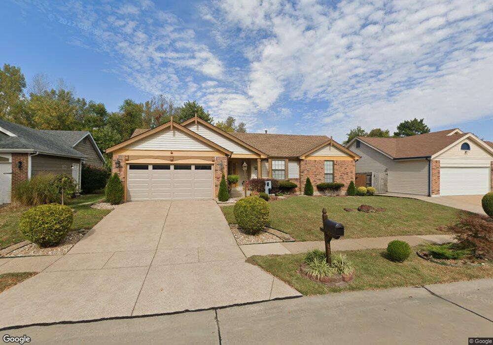
619 Foxtail Dr Florissant, MO 63034
Estimated Value: $227,000 - $271,000
3
Beds
2
Baths
1,407
Sq Ft
$174/Sq Ft
Est. Value
About This Home
This home is located at 619 Foxtail Dr, Florissant, MO 63034 and is currently estimated at $244,744, approximately $173 per square foot. 619 Foxtail Dr is a home located in St. Louis County with nearby schools including Barrington Elementary School, North Middle School, and Hazelwood Central High School.
Ownership History
Date
Name
Owned For
Owner Type
Purchase Details
Closed on
Aug 29, 2003
Sold by
Cambron James L and Cambron Dorothy L
Bought by
Holman Wade
Current Estimated Value
Purchase Details
Closed on
Mar 23, 1999
Sold by
Cambron James L and Cambron Dorothy L
Bought by
Cambron James L and Cambron Dorothy L
Home Financials for this Owner
Home Financials are based on the most recent Mortgage that was taken out on this home.
Original Mortgage
$45,000
Interest Rate
6.89%
Create a Home Valuation Report for This Property
The Home Valuation Report is an in-depth analysis detailing your home's value as well as a comparison with similar homes in the area
Home Values in the Area
Average Home Value in this Area
Purchase History
| Date | Buyer | Sale Price | Title Company |
|---|---|---|---|
| Holman Wade | $140,000 | -- | |
| Cambron James L | -- | -- |
Source: Public Records
Mortgage History
| Date | Status | Borrower | Loan Amount |
|---|---|---|---|
| Previous Owner | Cambron James L | $45,000 |
Source: Public Records
Tax History Compared to Growth
Tax History
| Year | Tax Paid | Tax Assessment Tax Assessment Total Assessment is a certain percentage of the fair market value that is determined by local assessors to be the total taxable value of land and additions on the property. | Land | Improvement |
|---|---|---|---|---|
| 2025 | $3,444 | $40,660 | $4,960 | $35,700 |
| 2024 | $3,444 | $37,880 | $4,290 | $33,590 |
| 2023 | $3,432 | $37,880 | $4,290 | $33,590 |
| 2022 | $3,123 | $30,640 | $6,590 | $24,050 |
| 2021 | $2,956 | $30,640 | $6,590 | $24,050 |
| 2020 | $2,548 | $24,570 | $4,960 | $19,610 |
| 2019 | $2,507 | $24,570 | $4,960 | $19,610 |
| 2018 | $2,304 | $20,860 | $3,270 | $17,590 |
| 2017 | $2,302 | $20,860 | $3,270 | $17,590 |
| 2016 | $2,020 | $17,980 | $3,270 | $14,710 |
| 2015 | $1,974 | $17,980 | $3,270 | $14,710 |
| 2014 | $2,364 | $21,490 | $4,220 | $17,270 |
Source: Public Records
Map
Nearby Homes
- 623 Bugle Run Dr
- 3811 Halter Ct
- 15645 Chaste St
- 15520 97th Ave
- 1056 Saratoga Springs Ct
- 15509 Debridge Way
- 3914 Birkemeier Dr
- 985 Brookfield Chase Ct
- 15561 Debridge Way
- 16256 Rose Wreath Ln Unit 156
- 4120 90th Ave
- 4242 Vaile Ave
- 15467 Jost Main St
- 1323 Woodpath Dr
- 15412 Forte de France Ln
- 3213 Yvette Ct
- 3830 Arbre Ln
- 3716 Rue de Renard
- 1114 Ransome Ct
- 1266 Borden Dr
- 615 Foxtail Dr
- 623 Foxtail Dr
- 611 Foxtail Dr
- 627 Foxtail Dr
- 620 Foxtail Dr
- 616 Foxtail Dr
- 631 Foxtail Dr
- 607 Foxtail Dr
- 624 Foxtail Dr
- 612 Foxtail Dr
- 628 Foxtail Dr
- 608 Foxtail Dr
- 635 Foxtail Dr
- 603 Foxtail Dr
- 4163 Fox Crossing Dr
- 634 Foxtail Dr
- 947 Keeneland Rd
- 604 Foxtail Dr
- 4167 Fox Crossing Dr
- 4068 Tera Bera Dr