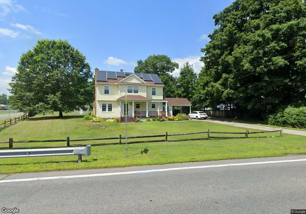
619 Main St Wilbraham, MA 01095
Estimated Value: $412,000 - $507,000
4
Beds
2
Baths
1,968
Sq Ft
$230/Sq Ft
Est. Value
About This Home
This home is located at 619 Main St, Wilbraham, MA 01095 and is currently estimated at $453,289, approximately $230 per square foot. 619 Main St is a home located in Hampden County with nearby schools including Minnechaug Regional High School, Springfield International Charter School, and Wilbraham & Monson Academy.
Ownership History
Date
Name
Owned For
Owner Type
Purchase Details
Closed on
Apr 3, 1998
Sold by
Mccarthy John W and Mccarthy Veronica C
Bought by
Decarolis Steven and Decarolis Jillmarie
Current Estimated Value
Purchase Details
Closed on
Jun 2, 1997
Sold by
Rochira Edmond P and Clarkin Bruce D
Bought by
Mccarthy John W and Mccarthy Veronica C
Create a Home Valuation Report for This Property
The Home Valuation Report is an in-depth analysis detailing your home's value as well as a comparison with similar homes in the area
Home Values in the Area
Average Home Value in this Area
Purchase History
| Date | Buyer | Sale Price | Title Company |
|---|---|---|---|
| Decarolis Steven | $112,000 | -- | |
| Mccarthy John W | $80,000 | -- |
Source: Public Records
Mortgage History
| Date | Status | Borrower | Loan Amount |
|---|---|---|---|
| Open | Mccarthy John W | $189,000 | |
| Closed | Mccarthy John W | $206,400 | |
| Closed | Mccarthy John W | $15,000 |
Source: Public Records
Tax History Compared to Growth
Tax History
| Year | Tax Paid | Tax Assessment Tax Assessment Total Assessment is a certain percentage of the fair market value that is determined by local assessors to be the total taxable value of land and additions on the property. | Land | Improvement |
|---|---|---|---|---|
| 2025 | $7,372 | $412,300 | $120,600 | $291,700 |
| 2024 | $7,498 | $405,300 | $120,600 | $284,700 |
| 2023 | $7,005 | $374,600 | $120,600 | $254,000 |
| 2022 | $7,247 | $353,700 | $120,600 | $233,100 |
| 2021 | $5,949 | $259,100 | $98,400 | $160,700 |
| 2020 | $5,799 | $259,100 | $98,400 | $160,700 |
| 2019 | $5,651 | $259,200 | $98,400 | $160,800 |
| 2018 | $5,655 | $249,800 | $98,400 | $151,400 |
| 2017 | $5,496 | $249,800 | $98,400 | $151,400 |
| 2016 | $5,419 | $250,900 | $108,900 | $142,000 |
| 2015 | $5,239 | $250,900 | $108,900 | $142,000 |
Source: Public Records
Map
Nearby Homes
- 68 Monson Rd
- 1028 Tinkham Rd
- 6 Katie St
- 8 Patriot Ridge Ln
- 6 Hilltop Park
- 760 Stony Hill Rd
- 767 Stony Hill Rd
- 763 Stony Hill Rd
- 14 Brookdale Dr
- 12 Highridge Rd
- 17 Peak Rd
- 751 Ridge Rd
- 5 Edgewood Rd
- 2 Bayberry Dr Unit 51
- 230V Burleigh Rd
- 5 Old Carriage Dr
- 407 Monson Rd
- 474 Mountain Rd
- 28 Decorie Dr
- 500 Springfield St
- 615 Main St
- 624 Main St
- 614 Main St
- 603 Main St
- 4 Church Ln
- 648 Main St
- 11 Willow Brook Ln
- 604 Main St
- 5 Willow Brook Ln
- 5 Willow Brook Ln
- 9 Willow Brook Ln
- 3 Willow Brook Ln
- 6 Church Ln
- Lot 7 Willow Brook Ln
- 651 Main St
- 7 Willow Brook Ln
- 7 Willow Brook Ln
- 8 Willow Brook Ln
- 12 Willow Brook Ln
- 6 Willow Brook Ln