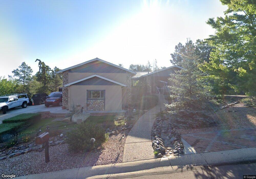
619 Thunderbird Dr Prescott, AZ 86303
Estimated Value: $564,706 - $656,000
--
Bed
--
Bath
2,016
Sq Ft
$309/Sq Ft
Est. Value
About This Home
This home is located at 619 Thunderbird Dr, Prescott, AZ 86303 and is currently estimated at $623,427, approximately $309 per square foot. 619 Thunderbird Dr is a home located in Yavapai County with nearby schools including Lincoln Elementary School, Granite Mountain Middle School, and Prescott Mile High Middle School.
Ownership History
Date
Name
Owned For
Owner Type
Purchase Details
Closed on
Nov 9, 2012
Sold by
Abramczyk Mary Ann and Harrison Janice
Bought by
Harrison Janice
Current Estimated Value
Purchase Details
Closed on
May 30, 2006
Sold by
Pierce Lavada
Bought by
Pierce Rick David
Purchase Details
Closed on
May 19, 2006
Sold by
Erickson Sharlin Carol and Pierce Sharlin Carol
Bought by
Pierce Rick David
Purchase Details
Closed on
Dec 15, 2003
Sold by
Hinshaw Dean and Hinshaw Elizabeth
Bought by
Hinshaw Dean and Hinshaw Elizabeth
Purchase Details
Closed on
Mar 18, 1996
Sold by
Worsham Herman D and Worsham Erline E
Bought by
Rabe Larry R
Purchase Details
Closed on
Jul 12, 1994
Sold by
King Valerie D
Bought by
King Robert E
Purchase Details
Closed on
Mar 30, 1994
Sold by
Bunts Len
Bought by
King Robert E and King Valerie D
Create a Home Valuation Report for This Property
The Home Valuation Report is an in-depth analysis detailing your home's value as well as a comparison with similar homes in the area
Home Values in the Area
Average Home Value in this Area
Purchase History
| Date | Buyer | Sale Price | Title Company |
|---|---|---|---|
| Harrison Janice | -- | None Available | |
| Pierce Rick David | -- | Yavapai Title Agency Inc | |
| Pierce Rick David | -- | Yavapai Title Agency Inc | |
| Hinshaw Dean | -- | Yavapai Title Agency | |
| Rabe Larry R | -- | -- | |
| King Robert E | -- | -- | |
| King Robert E | -- | -- | |
| Bunts Len | -- | -- |
Source: Public Records
Tax History Compared to Growth
Tax History
| Year | Tax Paid | Tax Assessment Tax Assessment Total Assessment is a certain percentage of the fair market value that is determined by local assessors to be the total taxable value of land and additions on the property. | Land | Improvement |
|---|---|---|---|---|
| 2026 | $1,554 | $56,954 | -- | -- |
| 2024 | $1,521 | $53,306 | -- | -- |
| 2023 | $1,521 | $43,831 | $12,721 | $31,110 |
| 2022 | $1,500 | $36,430 | $10,136 | $26,294 |
| 2021 | $1,610 | $35,319 | $9,051 | $26,268 |
| 2020 | $1,617 | $0 | $0 | $0 |
| 2019 | $1,605 | $0 | $0 | $0 |
| 2018 | $1,534 | $0 | $0 | $0 |
| 2017 | $1,478 | $0 | $0 | $0 |
| 2016 | $1,472 | $0 | $0 | $0 |
| 2015 | $1,428 | $0 | $0 | $0 |
| 2014 | $1,434 | $0 | $0 | $0 |
Source: Public Records
Map
Nearby Homes
- 1483 Copper Basin Rd
- 651 Fiesta Ln
- 1411 Barranca Dr
- 1804 Pony Soldier Rd
- 1786 Rolling Hills Dr
- 740 Crosscreek Dr
- 855 Angelita Dr
- 740 Angelita Dr
- 740 Angelita Dr Unit 90
- 751 Babbling Brook
- 789 Crosscreek Dr
- 1944 Lazy Meadow Ln
- 1088 Pine Country Ct
- 674 Crosscreek Dr
- 640 Crosscreek Dr
- 760 Woodridge Ln
- 1224 Timber Point N
- 744 Woodridge Ln
- 705 S Rancho Vista Dr Unit 136
- 705 S Rancho Vista Dr
- 617 Thunderbird Dr
- 621 Thunderbird Dr
- 980 Copper Vista Dr
- 986 Copper Vista Dr
- 616 Thunderbird Dr
- 988 Copper Vista Dr
- 615 Thunderbird Dr
- 623 Thunderbird Dr
- 622 Thunderbird Dr
- 14 Copper Vista Dr
- 990 Copper Vista Dr
- 974 Copper Vista Dr
- 970 Copper Vista Dr Unit ONE
- 970 Copper Vista Dr
- 613 Thunderbird Dr
- 625 Thunderbird Dr
- 625 Thunderbird Dr
- 614 Thunderbird Dr
- 981 Copper Vista Dr
- 981 Copper Vista Dr Unit 1