Estimated Value: $521,000 - $540,946
4
Beds
3
Baths
1,997
Sq Ft
$266/Sq Ft
Est. Value
About This Home
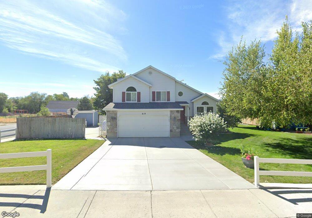
This home is located at 619 W 2180 N, Lehi, UT 84043 and is currently estimated at $531,237, approximately $266 per square foot. 619 W 2180 N is a home located in Utah County with nearby schools including Fox Hollow Elementary School and Skyridge High School.
Ownership History
Date
Name
Owned For
Owner Type
Purchase Details
Closed on
Oct 19, 2005
Sold by
Oswald Margaret M
Bought by
Goodwin Thomas and Goodwin Amy
Current Estimated Value
Home Financials for this Owner
Home Financials are based on the most recent Mortgage that was taken out on this home.
Original Mortgage
$172,600
Outstanding Balance
$92,267
Interest Rate
5.74%
Mortgage Type
FHA
Estimated Equity
$438,970
Purchase Details
Closed on
Mar 29, 2001
Sold by
Aldridge Margaret M
Bought by
Oswald Margaret M
Home Financials for this Owner
Home Financials are based on the most recent Mortgage that was taken out on this home.
Original Mortgage
$88,000
Interest Rate
7.06%
Purchase Details
Closed on
Nov 25, 1996
Sold by
Aldridge Scott E and Aldridge Margaret M
Bought by
Aldridge Margaret M
Create a Home Valuation Report for This Property
The Home Valuation Report is an in-depth analysis detailing your home's value as well as a comparison with similar homes in the area
Home Values in the Area
Average Home Value in this Area
Purchase History
| Date | Buyer | Sale Price | Title Company |
|---|---|---|---|
| Goodwin Thomas | -- | Utah First Title Insurance | |
| Oswald Margaret M | -- | Mountain West Title Co | |
| Aldridge Margaret M | -- | First American Title |
Source: Public Records
Mortgage History
| Date | Status | Borrower | Loan Amount |
|---|---|---|---|
| Open | Goodwin Thomas | $172,600 | |
| Previous Owner | Oswald Margaret M | $88,000 |
Source: Public Records
Tax History Compared to Growth
Tax History
| Year | Tax Paid | Tax Assessment Tax Assessment Total Assessment is a certain percentage of the fair market value that is determined by local assessors to be the total taxable value of land and additions on the property. | Land | Improvement |
|---|---|---|---|---|
| 2025 | $2,097 | $267,025 | $199,900 | $285,600 |
| 2024 | $2,097 | $245,410 | $0 | $0 |
| 2023 | $1,960 | $249,040 | $0 | $0 |
| 2022 | $2,073 | $255,310 | $0 | $0 |
| 2021 | $1,843 | $343,200 | $115,700 | $227,500 |
| 2020 | $1,737 | $319,700 | $107,100 | $212,600 |
| 2019 | $1,561 | $298,800 | $107,100 | $191,700 |
| 2018 | $1,468 | $265,500 | $97,700 | $167,800 |
| 2017 | $1,356 | $130,405 | $0 | $0 |
| 2016 | $1,341 | $119,680 | $0 | $0 |
| 2015 | $1,367 | $115,775 | $0 | $0 |
| 2014 | $1,253 | $105,545 | $0 | $0 |
Source: Public Records
Map
Nearby Homes
- 595 W 2200 N
- 497 W 2200 N
- 497 W 2280 N
- 2287 N 750 W
- 2159 N Banbury Ct
- 1755 N 250 W
- 1011 W Mountain Way Unit 316
- 1817 W Bad Rock Cir
- 537 W Sandhill Dr
- 668 W Sandhill Dr
- 804 W 2700 N
- 369 W 2730 N
- 2687 N 900 W
- 2778 N 930 W
- 902 W 1500 N
- 1272 W 1800 N
- 192 E 2200 N
- 4333 N Baiken Ridge Dr Unit 1020
- 2908 N 1080 W
- 2539 N 300 E