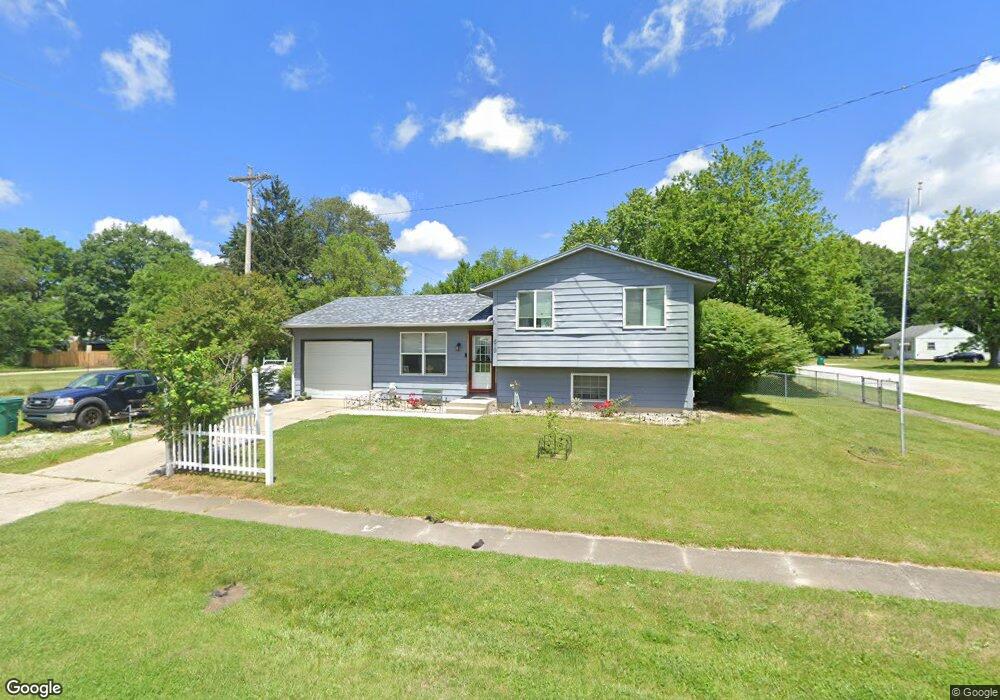
619 Wayland Rd La Porte, IN 46350
Estimated Value: $183,000 - $206,000
3
Beds
2
Baths
1,569
Sq Ft
$122/Sq Ft
Est. Value
About This Home
This home is located at 619 Wayland Rd, La Porte, IN 46350 and is currently estimated at $192,173, approximately $122 per square foot. 619 Wayland Rd is a home located in LaPorte County with nearby schools including Kingsford Heights Elementary School, La Porte High School, and Kesling Intermediate School.
Ownership History
Date
Name
Owned For
Owner Type
Purchase Details
Closed on
Sep 4, 2009
Sold by
Wells Fargo Bank National Association
Bought by
Johnson Geordia H
Current Estimated Value
Home Financials for this Owner
Home Financials are based on the most recent Mortgage that was taken out on this home.
Original Mortgage
$44,000
Outstanding Balance
$31,385
Interest Rate
5.19%
Mortgage Type
Unknown
Estimated Equity
$160,789
Purchase Details
Closed on
Jun 16, 2009
Sold by
Young Brian K and Young Kristin M
Bought by
Wells Fargo Bank National Association
Create a Home Valuation Report for This Property
The Home Valuation Report is an in-depth analysis detailing your home's value as well as a comparison with similar homes in the area
Home Values in the Area
Average Home Value in this Area
Purchase History
| Date | Buyer | Sale Price | Title Company |
|---|---|---|---|
| Johnson Geordia H | -- | Eagle Land Title | |
| Wells Fargo Bank National Association | $29,000 | None Available |
Source: Public Records
Mortgage History
| Date | Status | Borrower | Loan Amount |
|---|---|---|---|
| Open | Johnson Geordia H | $44,000 |
Source: Public Records
Tax History Compared to Growth
Tax History
| Year | Tax Paid | Tax Assessment Tax Assessment Total Assessment is a certain percentage of the fair market value that is determined by local assessors to be the total taxable value of land and additions on the property. | Land | Improvement |
|---|---|---|---|---|
| 2024 | $1,051 | $104,400 | $23,300 | $81,100 |
| 2022 | $825 | $94,000 | $17,700 | $76,300 |
| 2021 | $825 | $87,800 | $17,700 | $70,100 |
| 2020 | $670 | $87,800 | $17,700 | $70,100 |
| 2019 | $622 | $77,200 | $12,100 | $65,100 |
| 2018 | $674 | $78,600 | $12,100 | $66,500 |
| 2017 | $611 | $76,100 | $12,100 | $64,000 |
| 2016 | $511 | $66,600 | $8,500 | $58,100 |
| 2014 | $82 | $68,400 | $11,400 | $57,000 |
Source: Public Records
Map
Nearby Homes
- 904 Kenilworth Rd
- 814 Kenilworth Rd
- 902 Kenilworth Rd
- 908 Kenilworth Rd
- 906 Kenilworth Rd
- 908 Kenilworth Rd
- 906 Kenilworth Rd
- 904 Kenilworth Rd
- 901 Larchmere Rd
- 813 Larchmere Rd
- 815 Larchmere Rd
- 703 Dover Ct
- 705 Dover Ct
- 814 Kenilworth Rd
- 702 Edgemoor Rd
- 813 Larchmere Rd
- 701 Dover Ct
- 702 Dover Ct
- ESSEX Plan at Park Place South
- AUBURN Plan at Park Place South
- 550 Kenilworth Rd
- 622 Wayland Rd
- 525 Larchmere Rd
- 119 Vernon Ct
- 800 Wayland Rd
- 115 Vernon Ct
- 107 Vernon Ct
- 101 Vernon Ct
- 111 Vernon Ct
- 105 Vernon Ct
- 115 Vernon Ct
- 107 Vernon Ct
- 101 Vernon Ct
- 701 Wayland Rd
- 541 Kenilworth Rd
- 121 Vernon Ct
- 544 Kenilworth Rd
- 121 Vernon Ct
- 702 Wayland Rd
- 521 Larchmere Rd