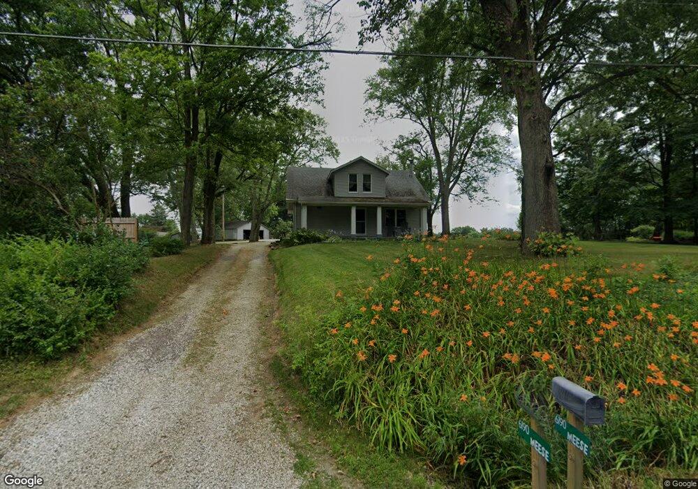
6190 Meese Rd NE Louisville, OH 44641
Estimated Value: $182,000 - $260,000
4
Beds
1
Bath
1,344
Sq Ft
$161/Sq Ft
Est. Value
About This Home
This home is located at 6190 Meese Rd NE, Louisville, OH 44641 and is currently estimated at $216,120, approximately $160 per square foot. 6190 Meese Rd NE is a home located in Stark County with nearby schools including Louisville High School.
Ownership History
Date
Name
Owned For
Owner Type
Purchase Details
Closed on
Sep 9, 2025
Sold by
Wheeler Douglas C and Wheeler Julie Y
Bought by
Wheeler Douglas C and Wheeler Julie Y
Current Estimated Value
Purchase Details
Closed on
Jun 24, 1999
Sold by
Andrews Oral L and Clevenger Oral L
Bought by
Wheeler Douglas C and Wheeler Julie Y
Home Financials for this Owner
Home Financials are based on the most recent Mortgage that was taken out on this home.
Original Mortgage
$61,750
Interest Rate
7.15%
Create a Home Valuation Report for This Property
The Home Valuation Report is an in-depth analysis detailing your home's value as well as a comparison with similar homes in the area
Home Values in the Area
Average Home Value in this Area
Purchase History
| Date | Buyer | Sale Price | Title Company |
|---|---|---|---|
| Wheeler Douglas C | -- | None Listed On Document | |
| Wheeler Douglas C | $65,000 | -- |
Source: Public Records
Mortgage History
| Date | Status | Borrower | Loan Amount |
|---|---|---|---|
| Previous Owner | Wheeler Douglas C | $61,750 |
Source: Public Records
Tax History Compared to Growth
Tax History
| Year | Tax Paid | Tax Assessment Tax Assessment Total Assessment is a certain percentage of the fair market value that is determined by local assessors to be the total taxable value of land and additions on the property. | Land | Improvement |
|---|---|---|---|---|
| 2025 | -- | $57,580 | $26,740 | $30,840 |
| 2024 | -- | $57,580 | $26,740 | $30,840 |
| 2023 | $2,277 | $46,590 | $19,080 | $27,510 |
| 2022 | $2,283 | $46,590 | $19,080 | $27,510 |
| 2021 | $2,290 | $46,590 | $19,080 | $27,510 |
| 2020 | $1,934 | $41,550 | $17,190 | $24,360 |
| 2019 | $1,942 | $41,550 | $17,190 | $24,360 |
| 2018 | $1,936 | $41,550 | $17,190 | $24,360 |
| 2017 | $1,933 | $39,630 | $15,120 | $24,510 |
| 2016 | $2,059 | $42,920 | $15,120 | $27,800 |
| 2015 | $2,064 | $42,920 | $15,120 | $27,800 |
| 2014 | $1,945 | $37,430 | $13,200 | $24,230 |
| 2013 | $976 | $37,430 | $13,200 | $24,230 |
Source: Public Records
Map
Nearby Homes
- 5990 Meese Rd NE
- 5765 Maplegrove St
- 5495 Meese Rd NE
- 6052 N Nickelplate St
- 6109 Oakhill Ave NE
- 12222 Cenfield St NE
- 2015 E Main St
- 1413 Washington Blvd
- 1812 E Broad St
- 0 Michigan Blvd
- 910 Crosswyck Cir
- 344 E Reno Dr
- 2110 Edmar St
- 316 E Reno Dr
- 1024 Washington Ave
- 7844 Morningstar Dr
- 10025 Georgetown St
- 617 Harrison St
- 8896 Rue Helena St
- 1104 E Broad St
- 6181 Paris Ave
- 6169 Paris Ave
- 6240 Paris Ave
- 6155 Paris Ave
- 6216 Paris Ave
- 6264 Paris Ave
- 6264 Paris Ave
- 6136 Meese Rd
- 6299 Paris Ave
- 6285 Meese Rd
- 6122 Meese Rd
- 6284 Meese Rd NE
- 6106 Meese Rd NE
- 6072 Paris Ave
- 6069 Paris Ave
- 6075 Paris Ave
- 6061 Paris Ave
- 6085 Meese Rd NE
- 6354 Meese Rd NE
- 6079 Meese Rd