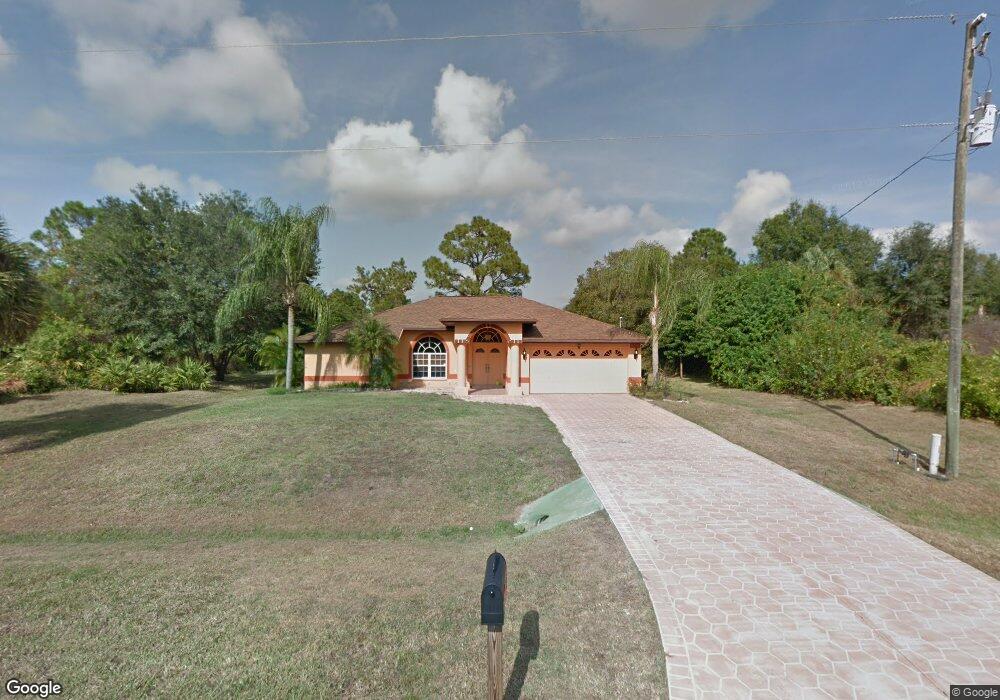
6198 E Hillsborough Blvd North Port, FL 34288
Estimated Value: $296,000 - $361,000
3
Beds
2
Baths
1,775
Sq Ft
$184/Sq Ft
Est. Value
About This Home
This home is located at 6198 E Hillsborough Blvd, North Port, FL 34288 and is currently estimated at $326,950, approximately $184 per square foot. 6198 E Hillsborough Blvd is a home with nearby schools including Atwater Elementary School, North Port High School, and Woodland Middle School.
Ownership History
Date
Name
Owned For
Owner Type
Purchase Details
Closed on
Oct 24, 2023
Sold by
Mohart Donna R
Bought by
Donna Rae Mohart Revocable Trust and Mohart
Current Estimated Value
Purchase Details
Closed on
Dec 7, 2016
Sold by
Flores George I and Harris Flores Calie L
Bought by
Mohart Donna R
Home Financials for this Owner
Home Financials are based on the most recent Mortgage that was taken out on this home.
Original Mortgage
$161,600
Interest Rate
3.57%
Mortgage Type
New Conventional
Purchase Details
Closed on
Feb 17, 1999
Sold by
Berg Milton
Bought by
Flores George I and Flores Nancy K
Create a Home Valuation Report for This Property
The Home Valuation Report is an in-depth analysis detailing your home's value as well as a comparison with similar homes in the area
Home Values in the Area
Average Home Value in this Area
Purchase History
| Date | Buyer | Sale Price | Title Company |
|---|---|---|---|
| Donna Rae Mohart Revocable Trust | $100 | None Listed On Document | |
| Mohart Donna R | $202,000 | Attorney | |
| Flores George I | $5,000 | -- | |
| Flores George I | $5,000 | -- |
Source: Public Records
Mortgage History
| Date | Status | Borrower | Loan Amount |
|---|---|---|---|
| Previous Owner | Mohart Donna R | $161,600 |
Source: Public Records
Tax History Compared to Growth
Tax History
| Year | Tax Paid | Tax Assessment Tax Assessment Total Assessment is a certain percentage of the fair market value that is determined by local assessors to be the total taxable value of land and additions on the property. | Land | Improvement |
|---|---|---|---|---|
| 2024 | $2,427 | $153,063 | -- | -- |
| 2023 | $2,427 | $148,605 | $0 | $0 |
| 2022 | $2,366 | $144,277 | $0 | $0 |
| 2021 | $2,318 | $140,075 | $0 | $0 |
| 2020 | $2,288 | $138,141 | $0 | $0 |
| 2019 | $2,209 | $135,035 | $0 | $0 |
| 2018 | $2,062 | $132,517 | $0 | $0 |
| 2017 | $2,035 | $130,629 | $0 | $0 |
| 2015 | $1,497 | $106,800 | $5,400 | $101,400 |
Source: Public Records
Map
Nearby Homes
- 0 Twisdale Cir Unit MFRC7491387
- 0 Twisdale Cir Unit 2025006186
- 0 Twisdale Cir Unit MFRC7491392
- 21084 Dearman Ave
- 21068 Dearman Ave
- 21060 Dearman Ave
- 19400 Veterans Blvd Unit 3
- LOT 13 Mattox Cir
- Lot 12 Mattox Cir
- Lot 7 Mattox Cir
- Lot 11 Mattox Cir
- 21036 Dearman Ave
- Lot 14 Penny Cir
- 0 Ashboro Cir Unit MFRTB8394497
- 0 Ashboro Cir Unit 224092982
- 74 Baldur Dr
- 195 Baldur Dr
- 79 Harvey St
- 215 Fletcher St
- Lot 3 Hamburg Dr
- Lot 6 E Hillsborough Blvd
- 4621 Mattox Cir
- 0 London Cir Unit N5911150
- 0 Hillsborough Blvd Unit C691762
- 0 Hillsborough Blvd Unit A4426697
- 14 London Cir
- 6054 E Hillsborough Blvd
- 6006 E Hillsborough Blvd
- 0 Twisdale Cir Unit MFRC7486404
- 0 Twisdale Cir Unit MFRC7486403
- 0 Twisdale Cir Unit MFRC7481945
- Lot 7 Twisdale Cir
- 1148204314 Twisdale Cir
- 0 Twisdale Cir Unit MFRA4574029
- 0 Twisdale Cir Unit C7470525
- 0 Twisdale Cir Unit C7221348
- 0 Twisdale Cir Unit C7442104
- 0 Twisdale Cir Unit C7027333
- 0 Twisdale Cir Unit C7027332
- 0 Twisdale Cir Unit C7038344