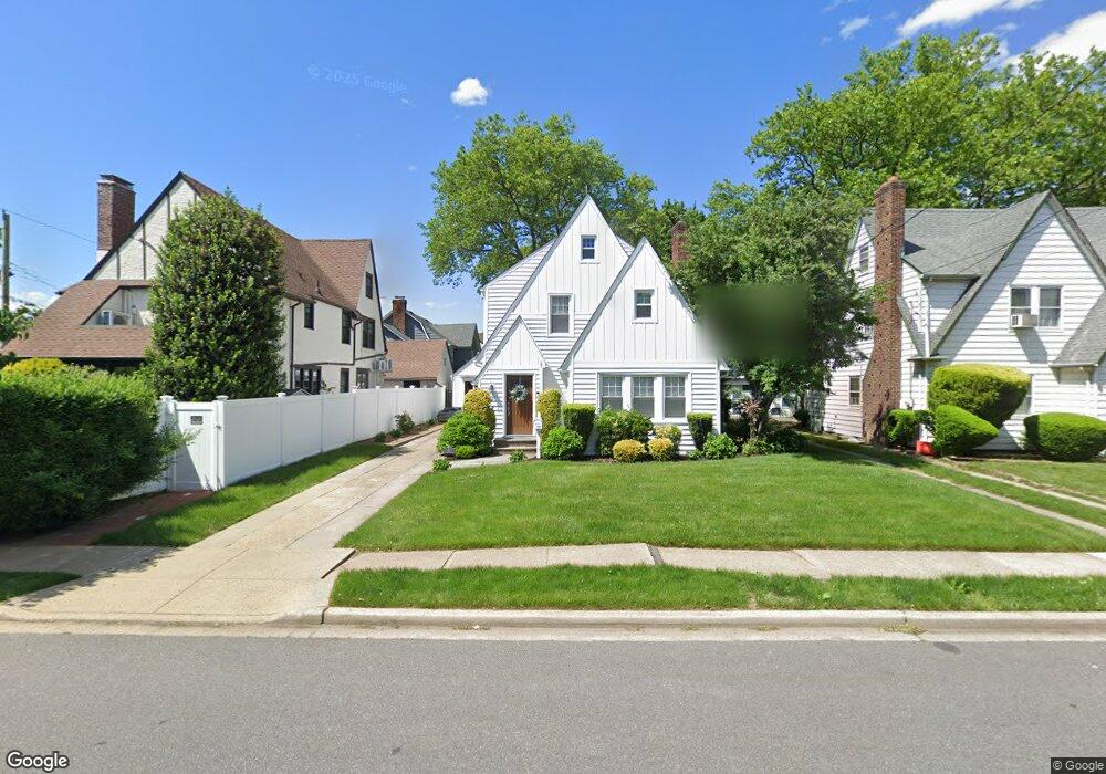
62 Argyle Rd West Hempstead, NY 11552
Estimated Value: $716,818 - $723,000
3
Beds
2
Baths
1,712
Sq Ft
$421/Sq Ft
Est. Value
About This Home
This home is located at 62 Argyle Rd, West Hempstead, NY 11552 and is currently estimated at $719,909, approximately $420 per square foot. 62 Argyle Rd is a home located in Nassau County with nearby schools including Chestnut Street School, West Hempstead Middle School, and West Hempstead Secondary School.
Ownership History
Date
Name
Owned For
Owner Type
Purchase Details
Closed on
Jul 28, 2022
Sold by
Murphy Eileen M and Kelly Eileen M
Bought by
Singh Nekita and Singh Lalman
Current Estimated Value
Home Financials for this Owner
Home Financials are based on the most recent Mortgage that was taken out on this home.
Original Mortgage
$522,750
Outstanding Balance
$499,649
Interest Rate
5.81%
Mortgage Type
New Conventional
Estimated Equity
$220,260
Purchase Details
Closed on
Jan 23, 2004
Sold by
Kelly Thomas
Purchase Details
Closed on
Nov 20, 2001
Sold by
Ollquist Thomas A
Bought by
Kelly Thomas J and Kelly Eileen M.
Create a Home Valuation Report for This Property
The Home Valuation Report is an in-depth analysis detailing your home's value as well as a comparison with similar homes in the area
Home Values in the Area
Average Home Value in this Area
Purchase History
We collect this data history from publicly available records. To have your information removed, we recommend requesting removal directly through your county’s website.
| Date | Buyer | Sale Price | Title Company |
|---|---|---|---|
| Singh Nekita | $615,000 | Old Republic Natl Ttl Ins Co | |
| Singh Nekita | $615,000 | Old Republic Natl Ttl Ins Co | |
| Singh Nekita | $615,000 | Old Republic Natl Ttl Ins Co | |
| Singh Nekita | $615,000 | Old Republic Natl Ttl Ins Co | |
| -- | -- | -- | |
| -- | -- | -- | |
| Kelly Thomas J | $250,000 | Martin Milner | |
| Kelly Thomas J | $250,000 | Martin Milner |
Source: Public Records
Mortgage History
We collect this data history from publicly available records. To have your information removed, we recommend requesting removal directly through your county’s website.
| Date | Status | Borrower | Loan Amount |
|---|---|---|---|
| Open | Singh Nekita | $522,750 | |
| Closed | Singh Nekita | $522,750 |
Source: Public Records
Tax History
| Year | Tax Paid | Tax Assessment Tax Assessment Total Assessment is a certain percentage of the fair market value that is determined by local assessors to be the total taxable value of land and additions on the property. | Land | Improvement |
|---|---|---|---|---|
| 2025 | $15,414 | $487 | $147 | $340 |
| 2024 | $4,230 | $487 | $147 | $340 |
| 2023 | $13,253 | $491 | $149 | $342 |
| 2022 | $13,253 | $487 | $147 | $340 |
| 2021 | $14,224 | $496 | $150 | $346 |
| 2020 | $13,381 | $720 | $495 | $225 |
| 2019 | $4,443 | $785 | $540 | $245 |
| 2018 | $4,337 | $785 | $0 | $0 |
| 2017 | $8,811 | $785 | $540 | $245 |
| 2016 | $12,619 | $785 | $540 | $245 |
| 2015 | $3,551 | $785 | $540 | $245 |
| 2014 | $3,551 | $785 | $540 | $245 |
| 2013 | $3,320 | $785 | $540 | $245 |
Source: Public Records
Map
Nearby Homes
- 73 Stratford Rd
- 139 Stevens Ave
- 42 Mead St
- 79 Hempstead Turnpike
- 30 Alicia Ct
- 39 Cynthia Ct
- 4 May Ct
- 170 Ivy St
- 159 Avon Place
- 34 Cathedral Ave Unit 6A
- 22 Mulford Place Unit 2D
- 22 Mulford Place Unit 5C
- 32 Cathedral Ave Unit 6c
- 191 Cathedral Ave
- 101 Long Dr
- 93 Woodview Rd
- 35 Mulford Place
- 227 Concord Ave
- 129 Hilton Ave
- 14 Parsons Dr
Your Personal Tour Guide
Ask me questions while you tour the home.