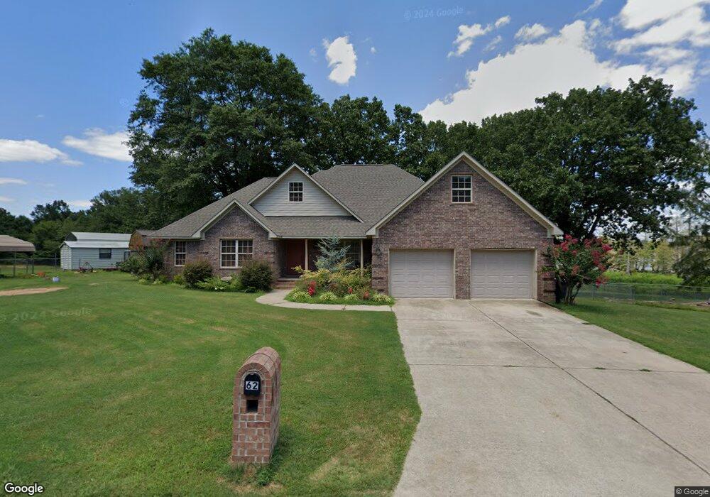
62 Brannon Landing Rd Conway, AR 72032
Estimated Value: $240,000 - $332,000
--
Bed
1
Bath
2,595
Sq Ft
$111/Sq Ft
Est. Value
About This Home
This home is located at 62 Brannon Landing Rd, Conway, AR 72032 and is currently estimated at $287,517, approximately $110 per square foot. 62 Brannon Landing Rd is a home with nearby schools including Preston & Florence Mattison Elementary School, Bob Courtway Middle School, and Conway Junior High School.
Ownership History
Date
Name
Owned For
Owner Type
Purchase Details
Closed on
Nov 22, 2022
Sold by
Pearce Larry A and Pearce Jessie
Bought by
Pearce Jeffery and Pearce Haven
Current Estimated Value
Purchase Details
Closed on
Feb 25, 2005
Bought by
Wastewater Line Easement
Purchase Details
Closed on
Sep 13, 1993
Bought by
Larry Pearce
Purchase Details
Closed on
Aug 26, 1993
Bought by
Jimmy
Create a Home Valuation Report for This Property
The Home Valuation Report is an in-depth analysis detailing your home's value as well as a comparison with similar homes in the area
Home Values in the Area
Average Home Value in this Area
Purchase History
| Date | Buyer | Sale Price | Title Company |
|---|---|---|---|
| Pearce Jeffery | -- | None Listed On Document | |
| Wastewater Line Easement | -- | -- | |
| Larry Pearce | $6,000 | -- | |
| Jimmy | -- | -- | |
| Fr Jimmy | -- | -- |
Source: Public Records
Tax History Compared to Growth
Tax History
| Year | Tax Paid | Tax Assessment Tax Assessment Total Assessment is a certain percentage of the fair market value that is determined by local assessors to be the total taxable value of land and additions on the property. | Land | Improvement |
|---|---|---|---|---|
| 2025 | $2,329 | $68,680 | $2,850 | $65,830 |
| 2024 | $2,223 | $68,680 | $2,850 | $65,830 |
| 2023 | $2,118 | $50,550 | $2,850 | $47,700 |
| 2022 | $1,716 | $50,550 | $2,850 | $47,700 |
| 2021 | $1,594 | $50,550 | $2,850 | $47,700 |
| 2020 | $1,502 | $39,700 | $2,220 | $37,480 |
| 2019 | $1,502 | $39,700 | $2,220 | $37,480 |
| 2018 | $1,527 | $39,700 | $2,220 | $37,480 |
| 2017 | $1,527 | $39,700 | $2,220 | $37,480 |
| 2016 | $1,527 | $39,700 | $2,220 | $37,480 |
| 2015 | $1,845 | $39,770 | $2,220 | $37,550 |
| 2014 | $1,530 | $39,770 | $2,220 | $37,550 |
Source: Public Records
Map
Nearby Homes
- lot 7 Shady Point Dr
- 12 Dunbar Rd
- 38 Windwood Loop
- 256 Caney Creek Rd
- 43 Lawrence Landing Rd
- 60 Wilhelmina Cove
- 63 Wilhelmina Cove Rd
- 260 Sturgis Rd
- 5 Thomas Ln
- 000 Bream Nest Rd
- 237 Sturgis Rd
- 25 Fred Ln
- 24 Sierra Dr
- 6 Round Mountain Rd
- 5 Round Mountain Rd
- 380 Sturgis Rd
- 104 Lawrence Landing Rd
- 00 Kaps Landing Rd
- 114 Lawrence Landing Rd
- 30 Round Mountain Rd
- 60 Brannon Landing Rd
- 58 Brannon Landing Rd
- 0 Brannon Landing Rd
- 64 Brannon Landing Rd
- 25 3rd Cir
- 25 Third Cir
- 24 3rd Cir
- 66 Brannon Landing Rd
- 27 3rd Cir
- 67 Brannon Landing Rd
- 68 Brannon Landing Rd
- 53 Brannon Landing Rd
- 28 3rd Cir
- 70 Brannon Landing Rd
- 0 Brannon Landing
- 19 3rd Cir
- 30 3rd Cir
- 4 Thatcher Ln
- 30 Third Cir
- 32 3rd Cir