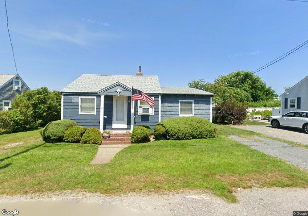
62 Hartford Rd Marshfield, MA 02050
Ocean Bluff-Brant Rock NeighborhoodEstimated Value: $546,000 - $599,000
2
Beds
2
Baths
702
Sq Ft
$806/Sq Ft
Est. Value
About This Home
This home is located at 62 Hartford Rd, Marshfield, MA 02050 and is currently estimated at $566,149, approximately $806 per square foot. 62 Hartford Rd is a home located in Plymouth County with nearby schools including Daniel Webster, Furnace Brook Middle School, and Marshfield High School.
Ownership History
Date
Name
Owned For
Owner Type
Purchase Details
Closed on
Jan 23, 2018
Sold by
King Patrick J and King Sheila
Bought by
P J & S Donahue King Irt and Donahue-King
Current Estimated Value
Purchase Details
Closed on
Mar 31, 2009
Sold by
King Hartford Nt and King
Bought by
King Patrick J and King Sheila
Purchase Details
Closed on
Dec 15, 2006
Sold by
King Patrick J and King Kathleen
Bought by
King Hartford Nt and King
Create a Home Valuation Report for This Property
The Home Valuation Report is an in-depth analysis detailing your home's value as well as a comparison with similar homes in the area
Home Values in the Area
Average Home Value in this Area
Purchase History
| Date | Buyer | Sale Price | Title Company |
|---|---|---|---|
| P J & S Donahue King Irt | -- | None Available | |
| King Patrick J | -- | -- | |
| King Patrick J | -- | -- | |
| King Hartford Nt | -- | -- | |
| King Hartford Nt | -- | -- |
Source: Public Records
Mortgage History
| Date | Status | Borrower | Loan Amount |
|---|---|---|---|
| Previous Owner | King Hartford Nt | $17,800 |
Source: Public Records
Tax History Compared to Growth
Tax History
| Year | Tax Paid | Tax Assessment Tax Assessment Total Assessment is a certain percentage of the fair market value that is determined by local assessors to be the total taxable value of land and additions on the property. | Land | Improvement |
|---|---|---|---|---|
| 2025 | $4,468 | $451,300 | $317,700 | $133,600 |
| 2024 | $4,335 | $417,200 | $297,900 | $119,300 |
| 2023 | $4,118 | $375,100 | $268,100 | $107,000 |
| 2022 | $4,118 | $318,000 | $228,400 | $89,600 |
| 2021 | $3,979 | $301,700 | $218,400 | $83,300 |
| 2020 | $3,606 | $270,500 | $188,600 | $81,900 |
| 2019 | $3,516 | $262,800 | $188,600 | $74,200 |
| 2018 | $3,486 | $260,700 | $188,600 | $72,100 |
| 2017 | $3,337 | $243,200 | $178,700 | $64,500 |
| 2016 | $3,160 | $227,700 | $168,800 | $58,900 |
| 2015 | $2,972 | $223,600 | $168,800 | $54,800 |
| 2014 | $2,950 | $222,000 | $168,800 | $53,200 |
Source: Public Records
Map
Nearby Homes
- 81 Constellation Rd
- 11 Leon St
- 809 Ocean St
- 24 Second (2nd) Rd
- 19 2nd Rd
- 55 Abbey St
- 32 Gratto Rd
- 30 Chandler Dr
- 78 Tower Ave
- 8 Duxbury St
- 335 Ocean St
- 328 Ocean St
- K10-07-05 Alden St
- 255 Ridge Rd
- 256 Ocean St
- 95 Telegraph Hill Rd
- 29 Oxen Dr
- 90 Presidential Cir
- 39 High Beacon Way
- 92 Salt Meadow Waye
- 66 Hartford Rd
- 56 Hartford Rd
- 61 Hartford Rd
- 61 Hartford Rd Unit 1
- 55 Surf Ave
- 55 Surf Ave
- 55 Surf Ave Unit 1
- 605 Plymouth Ave
- 21 Mayflower Lane (Winter Rental) Unit 1
- 21 Mayflower Lane (Winter Rental)
- 21 Mayflower Ln
- 21 Mayflower Ln
- 78 Hartford Rd
- 51 Surf Ave
- 48 Hartford Rd
- 75 Hartford Rd
- 75 Hartford Rd Unit 1
- 75 Hartford Rd
- 74 Surf Ave
- 10 Mayflower Ln