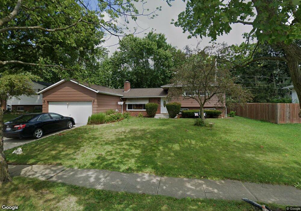
62 Hayes Dr Delaware, OH 43015
Estimated Value: $309,870 - $352,000
3
Beds
2
Baths
2,188
Sq Ft
$154/Sq Ft
Est. Value
About This Home
This home is located at 62 Hayes Dr, Delaware, OH 43015 and is currently estimated at $335,968, approximately $153 per square foot. 62 Hayes Dr is a home located in Delaware County with nearby schools including David Smith Elementary School, John C. Dempsey Middle School, and Rutherford B. Hayes High School.
Ownership History
Date
Name
Owned For
Owner Type
Purchase Details
Closed on
Aug 17, 2017
Sold by
Brimhall Donald M and Brimhall Stephanye N
Bought by
Terry Elizabeth and Brimhall Gregory
Current Estimated Value
Purchase Details
Closed on
Dec 10, 1997
Sold by
Est Robert J Morgan
Bought by
Brimhall Donald M and Brimhall Stephanye N
Home Financials for this Owner
Home Financials are based on the most recent Mortgage that was taken out on this home.
Original Mortgage
$79,900
Outstanding Balance
$13,625
Interest Rate
7.32%
Mortgage Type
New Conventional
Estimated Equity
$322,343
Create a Home Valuation Report for This Property
The Home Valuation Report is an in-depth analysis detailing your home's value as well as a comparison with similar homes in the area
Home Values in the Area
Average Home Value in this Area
Purchase History
| Date | Buyer | Sale Price | Title Company |
|---|---|---|---|
| Terry Elizabeth | -- | None Available | |
| Brimhall Donald M | $99,900 | -- |
Source: Public Records
Mortgage History
| Date | Status | Borrower | Loan Amount |
|---|---|---|---|
| Open | Brimhall Donald M | $79,900 |
Source: Public Records
Tax History
| Year | Tax Paid | Tax Assessment Tax Assessment Total Assessment is a certain percentage of the fair market value that is determined by local assessors to be the total taxable value of land and additions on the property. | Land | Improvement |
|---|---|---|---|---|
| 2024 | $3,854 | $91,430 | $16,840 | $74,590 |
| 2023 | $3,891 | $91,430 | $16,840 | $74,590 |
| 2022 | $3,516 | $73,260 | $11,730 | $61,530 |
| 2021 | $3,594 | $73,260 | $11,730 | $61,530 |
| 2020 | $3,635 | $73,260 | $11,730 | $61,530 |
| 2019 | $3,149 | $59,400 | $10,190 | $49,210 |
| 2018 | $3,193 | $59,400 | $10,190 | $49,210 |
| 2017 | $3,162 | $52,510 | $9,490 | $43,020 |
| 2016 | $2,517 | $52,510 | $9,490 | $43,020 |
| 2015 | $2,531 | $52,510 | $9,490 | $43,020 |
| 2014 | $2,571 | $52,510 | $9,490 | $43,020 |
| 2013 | $2,664 | $53,840 | $9,490 | $44,350 |
Source: Public Records
Map
Nearby Homes
- 269 W Heffner St
- 60 Orchard Heights
- 37 Spencer St
- 451 Federal Cir
- 610 Executive Blvd
- 510 Supreme Ct
- 111 Campbell St
- 602 Heritage Blvd
- 117 Middlemead St
- 269 Eastwood Ave
- 0 N Liberty St
- 290 N Liberty St
- 586 Willis Ln
- 151 W Lincoln Ave
- 245 Troy Rd
- 392 Rutherford Ave
- 102 W Lincoln Ave
- 263 N Franklin St
- 77 W Lincoln Ave
- 660 Birchard Ave
Your Personal Tour Guide
Ask me questions while you tour the home.