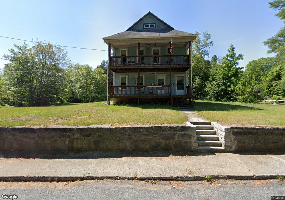
62 Hazel St Uxbridge, MA 01569
Estimated Value: $443,926 - $580,000
6
Beds
2
Baths
2,496
Sq Ft
$212/Sq Ft
Est. Value
About This Home
This home is located at 62 Hazel St, Uxbridge, MA 01569 and is currently estimated at $529,982, approximately $212 per square foot. 62 Hazel St is a home located in Worcester County with nearby schools including Uxbridge High School, Our Lady of the Valley Regional School, and Whitinsville Christian School.
Ownership History
Date
Name
Owned For
Owner Type
Purchase Details
Closed on
May 23, 2002
Sold by
J&B Rt and Doubleday John R
Bought by
Doubleday Brian Edward
Current Estimated Value
Home Financials for this Owner
Home Financials are based on the most recent Mortgage that was taken out on this home.
Original Mortgage
$179,000
Outstanding Balance
$76,010
Interest Rate
7.01%
Mortgage Type
Purchase Money Mortgage
Estimated Equity
$453,972
Purchase Details
Closed on
Nov 1, 1996
Sold by
Sene Russell A and Sene Nancy E
Bought by
Doubleday John and Doubleday Beverly
Home Financials for this Owner
Home Financials are based on the most recent Mortgage that was taken out on this home.
Original Mortgage
$73,500
Interest Rate
8.07%
Mortgage Type
Purchase Money Mortgage
Create a Home Valuation Report for This Property
The Home Valuation Report is an in-depth analysis detailing your home's value as well as a comparison with similar homes in the area
Home Values in the Area
Average Home Value in this Area
Purchase History
| Date | Buyer | Sale Price | Title Company |
|---|---|---|---|
| Doubleday Brian Edward | $223,750 | -- | |
| Doubleday John | $105,000 | -- |
Source: Public Records
Mortgage History
| Date | Status | Borrower | Loan Amount |
|---|---|---|---|
| Open | Doubleday John | $15,000 | |
| Open | Doubleday John | $179,000 | |
| Previous Owner | Doubleday John | $73,500 |
Source: Public Records
Tax History
| Year | Tax Paid | Tax Assessment Tax Assessment Total Assessment is a certain percentage of the fair market value that is determined by local assessors to be the total taxable value of land and additions on the property. | Land | Improvement |
|---|---|---|---|---|
| 2025 | $51 | $389,400 | $133,600 | $255,800 |
| 2024 | $4,888 | $378,300 | $122,500 | $255,800 |
| 2023 | $4,636 | $332,300 | $111,300 | $221,000 |
| 2022 | $4,399 | $290,200 | $100,900 | $189,300 |
| 2021 | $4,292 | $271,300 | $96,500 | $174,800 |
| 2020 | $4,354 | $260,100 | $100,200 | $159,900 |
| 2019 | $4,322 | $249,100 | $92,800 | $156,300 |
| 2018 | $3,904 | $227,400 | $92,800 | $134,600 |
| 2017 | $3,926 | $231,500 | $87,300 | $144,200 |
| 2016 | $3,855 | $219,400 | $85,200 | $134,200 |
| 2015 | $3,731 | $214,400 | $85,200 | $129,200 |
Source: Public Records
Map
Nearby Homes
- 86 Hunter Rd
- 26 Rivulet St
- 16 Farnum St
- 5 Peter St Unit D
- 71 Rivulet St Unit B
- 79 High St
- 12 Hartford Ave E
- 3 Strathmore Shire Unit A
- 376 Douglas St
- 138 Elm St
- 61 Spring Hill Dr Unit 61
- 24 Olde Canal Way Unit 24
- 0 Homestead Ave
- 395 High St
- 218 E Hartford Ave Unit 218
- 235 Rivulet St
- 11 Summerfield Dr Unit 11
- 223 Mendon St
- 145 Mantell Rd
- 169 Mantell Rd
Your Personal Tour Guide
Ask me questions while you tour the home.