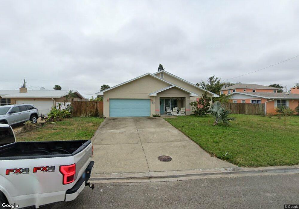
62 Ivanhoe Dr Ormond Beach, FL 32176
Estimated Value: $246,000 - $435,000
3
Beds
2
Baths
2,021
Sq Ft
$183/Sq Ft
Est. Value
About This Home
This home is located at 62 Ivanhoe Dr, Ormond Beach, FL 32176 and is currently estimated at $370,729, approximately $183 per square foot. 62 Ivanhoe Dr is a home located in Volusia County with nearby schools including Ormond Beach Middle School, Seabreeze High School, and Lourdes Academy.
Ownership History
Date
Name
Owned For
Owner Type
Purchase Details
Closed on
Apr 12, 2011
Sold by
Ormsby Diane
Bought by
Knight Eugene C and Knight Heidi T
Current Estimated Value
Purchase Details
Closed on
Mar 28, 2000
Sold by
Kruger Ruth and Caplan Ruth
Bought by
Ormsby Diane
Home Financials for this Owner
Home Financials are based on the most recent Mortgage that was taken out on this home.
Original Mortgage
$55,000
Interest Rate
8.38%
Purchase Details
Closed on
Jun 15, 1989
Bought by
Knight Eugene C and Knight Heidi T
Create a Home Valuation Report for This Property
The Home Valuation Report is an in-depth analysis detailing your home's value as well as a comparison with similar homes in the area
Home Values in the Area
Average Home Value in this Area
Purchase History
| Date | Buyer | Sale Price | Title Company |
|---|---|---|---|
| Knight Eugene C | $72,000 | Summit Title Group | |
| Ormsby Diane | $85,000 | -- | |
| Knight Eugene C | $70,000 | -- |
Source: Public Records
Mortgage History
| Date | Status | Borrower | Loan Amount |
|---|---|---|---|
| Previous Owner | Ormsby Diane | $55,000 |
Source: Public Records
Tax History
| Year | Tax Paid | Tax Assessment Tax Assessment Total Assessment is a certain percentage of the fair market value that is determined by local assessors to be the total taxable value of land and additions on the property. | Land | Improvement |
|---|---|---|---|---|
| 2026 | $1,242 | $121,501 | -- | -- |
| 2025 | $1,242 | $118,307 | -- | -- |
| 2024 | $1,142 | $114,973 | -- | -- |
| 2023 | $1,142 | $111,625 | $0 | $0 |
| 2022 | $1,094 | $108,374 | $0 | $0 |
| 2021 | $1,117 | $105,217 | $0 | $0 |
| 2020 | $1,094 | $103,764 | $0 | $0 |
| 2019 | $1,065 | $101,431 | $0 | $0 |
| 2018 | $1,061 | $99,540 | $0 | $0 |
| 2017 | $1,069 | $97,493 | $46,185 | $51,308 |
| 2016 | $1,761 | $90,686 | $0 | $0 |
| 2015 | $1,648 | $80,018 | $0 | $0 |
| 2014 | $1,556 | $77,073 | $0 | $0 |
Source: Public Records
Map
Nearby Homes
- 45 Loyola Dr
- 46 Marvin Rd
- 3041 N Oleander Ave
- 3013 N Halifax Ave Unit 3
- 3009 N Halifax Ave Unit 7
- 3009 N Halifax Ave Unit 1
- 3009 N Halifax Ave Unit 33
- 792 Marvin Rd
- 331 Fordham Dr
- 159 Ponce de Leon Dr
- 307 Emory Dr
- 150 Benjamin Dr
- 2711 N Halifax Ave Unit 695
- 2711 N Halifax Ave Unit 483
- 2711 N Halifax Ave Unit 375
- 2711 N Halifax Ave Unit 196
- 2711 N Halifax Ave Unit 288
- 2711 N Halifax Ave Unit 478
- 2711 N Halifax Ave Unit 184
- 2711 N Halifax Ave Unit 890
Your Personal Tour Guide
Ask me questions while you tour the home.