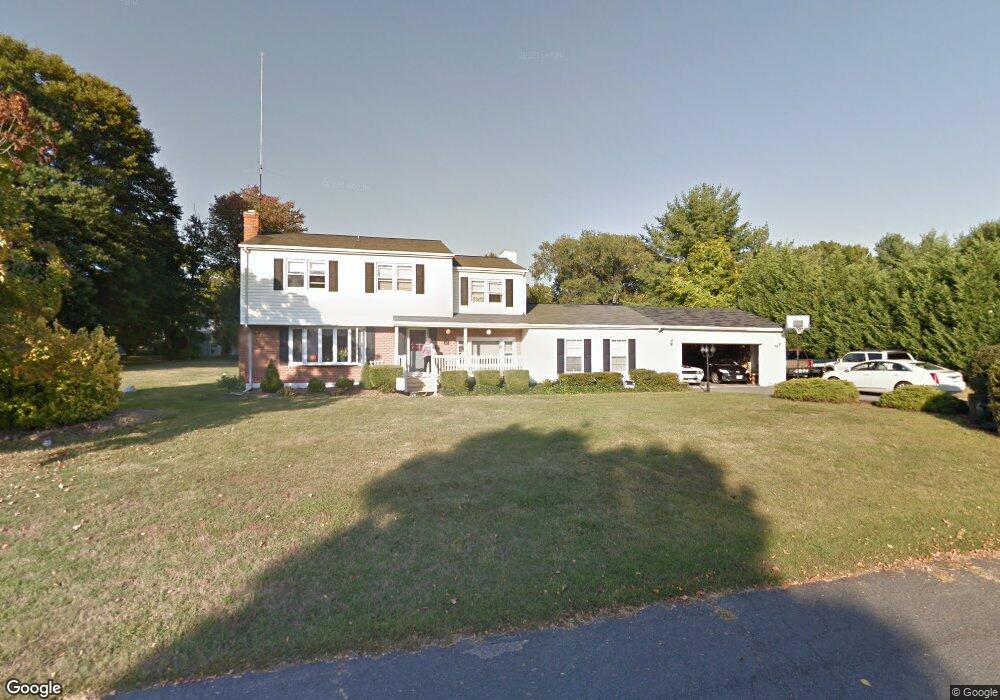
62 Milburn Cir Pasadena, MD 21122
Estimated Value: $693,759 - $814,000
--
Bed
3
Baths
2,888
Sq Ft
$254/Sq Ft
Est. Value
About This Home
This home is located at 62 Milburn Cir, Pasadena, MD 21122 and is currently estimated at $733,190, approximately $253 per square foot. 62 Milburn Cir is a home located in Anne Arundel County with nearby schools including Bodkin Elementary School, Chesapeake Bay Middle School, and Chesapeake High School.
Ownership History
Date
Name
Owned For
Owner Type
Purchase Details
Closed on
Nov 17, 1999
Sold by
Tan John Seng Yow
Bought by
Palma Timothy J and Palma Lisa M
Current Estimated Value
Purchase Details
Closed on
Apr 3, 1995
Sold by
Sank Joseph E
Bought by
Tan John S Y
Home Financials for this Owner
Home Financials are based on the most recent Mortgage that was taken out on this home.
Original Mortgage
$155,000
Interest Rate
8.8%
Create a Home Valuation Report for This Property
The Home Valuation Report is an in-depth analysis detailing your home's value as well as a comparison with similar homes in the area
Home Values in the Area
Average Home Value in this Area
Purchase History
| Date | Buyer | Sale Price | Title Company |
|---|---|---|---|
| Palma Timothy J | $214,897 | -- | |
| Tan John S Y | $180,000 | -- |
Source: Public Records
Mortgage History
| Date | Status | Borrower | Loan Amount |
|---|---|---|---|
| Previous Owner | Tan John S Y | $155,000 |
Source: Public Records
Tax History Compared to Growth
Tax History
| Year | Tax Paid | Tax Assessment Tax Assessment Total Assessment is a certain percentage of the fair market value that is determined by local assessors to be the total taxable value of land and additions on the property. | Land | Improvement |
|---|---|---|---|---|
| 2025 | $5,152 | $489,667 | -- | -- |
| 2024 | $5,152 | $438,700 | $227,500 | $211,200 |
| 2023 | $4,952 | $432,567 | $0 | $0 |
| 2022 | $4,627 | $426,433 | $0 | $0 |
| 2021 | $9,067 | $420,300 | $227,500 | $192,800 |
| 2020 | $3,482 | $420,300 | $227,500 | $192,800 |
| 2019 | $3,434 | $420,300 | $227,500 | $192,800 |
| 2018 | $4,748 | $468,200 | $259,500 | $208,700 |
| 2017 | $3,283 | $441,300 | $0 | $0 |
| 2016 | -- | $414,400 | $0 | $0 |
| 2015 | -- | $387,500 | $0 | $0 |
| 2014 | -- | $387,500 | $0 | $0 |
Source: Public Records
Map
Nearby Homes
- 0 Cornfield Rd Unit MDAA2129524
- 1590 Long Point Rd
- 222 Magothy Rd
- 1780 Chesapeake Place
- 1704 Twickenham Rd
- 1838 Chesapeake Rd
- 220 Falcon Dr
- 1807 Mountain Bay Road - Baltimore Model
- 216 Hickory Point Rd
- 8359 Forest Glen Dr
- 1533 Palm Ct
- 511 Sylvan Way
- 515 Sylview Drive - Sussex K Model
- 5108 Mountain Rd
- 1419 Pond Ridge Dr
- 8171 Bayside Dr
- 443 New York Ave
- 1592 Marco Dr
- 8198 Forest Glen Dr
- 0 Maryland Ave