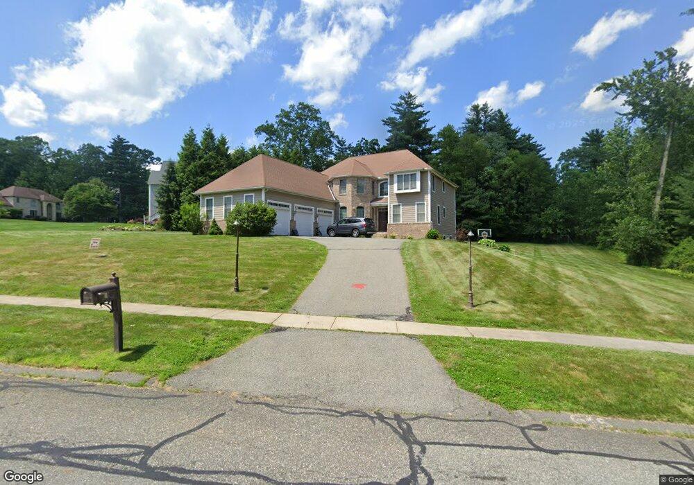
62 Orchard Rd East Longmeadow, MA 01028
Estimated Value: $836,000 - $974,000
4
Beds
4
Baths
4,090
Sq Ft
$223/Sq Ft
Est. Value
About This Home
This home is located at 62 Orchard Rd, East Longmeadow, MA 01028 and is currently estimated at $911,089, approximately $222 per square foot. 62 Orchard Rd is a home located in Hampden County with nearby schools including Meadowbrook Elementary School, Birchland Park Middle School, and East Longmeadow High School.
Ownership History
Date
Name
Owned For
Owner Type
Purchase Details
Closed on
Aug 18, 2010
Sold by
E Longmeadow Town Of
Bought by
Carroll James and Carroll Tracy W
Current Estimated Value
Purchase Details
Closed on
Jul 31, 2008
Sold by
Wesley Howard John and Mccain-Wesley Debbie
Bought by
Carroll James F and Carroll Tracey W
Home Financials for this Owner
Home Financials are based on the most recent Mortgage that was taken out on this home.
Original Mortgage
$417,000
Interest Rate
6.47%
Mortgage Type
Purchase Money Mortgage
Create a Home Valuation Report for This Property
The Home Valuation Report is an in-depth analysis detailing your home's value as well as a comparison with similar homes in the area
Home Values in the Area
Average Home Value in this Area
Purchase History
| Date | Buyer | Sale Price | Title Company |
|---|---|---|---|
| Carroll James | -- | -- | |
| Carroll James F | $610,000 | -- |
Source: Public Records
Mortgage History
| Date | Status | Borrower | Loan Amount |
|---|---|---|---|
| Previous Owner | Carroll James F | $417,000 |
Source: Public Records
Tax History Compared to Growth
Tax History
| Year | Tax Paid | Tax Assessment Tax Assessment Total Assessment is a certain percentage of the fair market value that is determined by local assessors to be the total taxable value of land and additions on the property. | Land | Improvement |
|---|---|---|---|---|
| 2025 | $15,344 | $830,300 | $143,400 | $686,900 |
| 2024 | $14,435 | $778,600 | $143,400 | $635,200 |
| 2023 | $13,716 | $714,400 | $131,000 | $583,400 |
| 2022 | $13,517 | $666,200 | $133,000 | $533,200 |
| 2021 | $13,369 | $634,800 | $123,400 | $511,400 |
| 2020 | $12,794 | $613,900 | $123,400 | $490,500 |
| 2019 | $12,272 | $597,200 | $119,800 | $477,400 |
| 2018 | $12,937 | $617,800 | $119,800 | $498,000 |
| 2017 | $12,612 | $607,200 | $129,000 | $478,200 |
| 2016 | $12,632 | $598,100 | $125,000 | $473,100 |
| 2015 | $12,393 | $598,100 | $125,000 | $473,100 |
Source: Public Records
Map
Nearby Homes
- 0 Apple Blossom Ln
- 399 Elm St
- 81 Oak Hollow Rd
- 17 Skyridge Ln
- 5 Kerry Dr
- 19 Ruthven St
- 71 Hilltop St
- 263 Cooley St
- 383 Porter Rd
- 65 Wilshire Rd
- 90 Feltham Rd
- 20 Maynard St
- 14 Porter Rd
- 331 Newhouse St
- 124 Sierra Vista Rd
- 152 Brookhaven Dr
- 86 Talmadge Dr
- 65 Fair Oak Rd
- 503 Parker St
- 121 W Crystal Brook Dr
- 6 Pine Grove Cir
- 16 Pine Grove Cir
- LOT 11 Deer Run Terrace
- "A" Gerrard Ave
- LOT 4 Deer Run Terrace
- Lot 34/35 Tufts St
- L 7 Yorkshire Place
- L 5 Yorkshire Place
- LOT 15 Windingbrook Land
- LOT C Porter Rd
- LOT 1 Shelby Ln
- L34/35 Tufts St
- LOT 36 Nottingham Meadows
- LOT 27 Nottingham Meadows
- LOT 31 Nottingham Meadows
- LOT 33 Nottingham Meadows
- LOT 35 Nottingham Meadows
- LOT 21 Nottingham Meadows
- L13R Maple St
- L 17A Vineland Ave