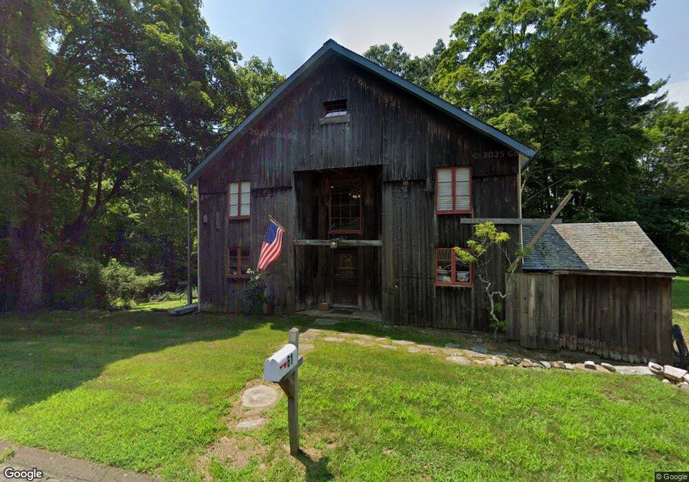
62 River Rd Killingworth, CT 06419
Estimated Value: $511,000 - $696,000
3
Beds
3
Baths
1,873
Sq Ft
$330/Sq Ft
Est. Value
About This Home
This home is located at 62 River Rd, Killingworth, CT 06419 and is currently estimated at $618,198, approximately $330 per square foot. 62 River Rd is a home located in Middlesex County with nearby schools including Haddam-Killingworth High School.
Ownership History
Date
Name
Owned For
Owner Type
Purchase Details
Closed on
Aug 12, 2002
Sold by
Moores Philip
Bought by
Downing Thomas B
Current Estimated Value
Home Financials for this Owner
Home Financials are based on the most recent Mortgage that was taken out on this home.
Original Mortgage
$204,000
Interest Rate
6.58%
Create a Home Valuation Report for This Property
The Home Valuation Report is an in-depth analysis detailing your home's value as well as a comparison with similar homes in the area
Home Values in the Area
Average Home Value in this Area
Purchase History
| Date | Buyer | Sale Price | Title Company |
|---|---|---|---|
| Downing Thomas B | $255,000 | -- |
Source: Public Records
Mortgage History
| Date | Status | Borrower | Loan Amount |
|---|---|---|---|
| Open | Downing Thomas B | $262,500 | |
| Closed | Downing Thomas B | $200,000 | |
| Closed | Downing Thomas B | $204,000 |
Source: Public Records
Tax History
| Year | Tax Paid | Tax Assessment Tax Assessment Total Assessment is a certain percentage of the fair market value that is determined by local assessors to be the total taxable value of land and additions on the property. | Land | Improvement |
|---|---|---|---|---|
| 2025 | $8,507 | $324,450 | $78,120 | $246,330 |
| 2024 | $7,858 | $324,450 | $78,120 | $246,330 |
| 2023 | $7,615 | $324,450 | $78,120 | $246,330 |
| 2022 | $7,534 | $324,450 | $78,120 | $246,330 |
| 2021 | $8,362 | $312,960 | $81,660 | $231,300 |
| 2020 | $8,362 | $312,960 | $81,660 | $231,300 |
| 2019 | $7,876 | $286,700 | $81,660 | $205,040 |
| 2018 | $7,695 | $280,140 | $81,660 | $198,480 |
| 2017 | $7,695 | $280,140 | $81,660 | $198,480 |
| 2016 | $7,430 | $286,980 | $122,260 | $164,720 |
| 2015 | $7,241 | $286,980 | $122,260 | $164,720 |
| 2014 | $7,040 | $286,980 | $122,260 | $164,720 |
Source: Public Records
Map
Nearby Homes
- 214 Green Hill Rd
- 743 Green Hill Rd
- 81 Strawberry Hill Rd
- 132 Summer Hill Rd
- 696 Green Hill Rd
- 25 Williamsburg Cir
- 462 Horse Pond Rd
- 70 High Hill Cir
- 90 Robin Ridge Dr
- 174 Concord Dr
- 30 Chestnut Hill Rd
- 21 Little Hollow Rd
- 85 Legend Hill Rd Unit 85
- 286 Opening Hill Rd
- 461 Green Hill Rd
- 244 Cow Hill Rd
- 6 Old Coach Rd
- 179 Route 81
- 115 Hemlock Dr
- 262 Connecticut 81
Your Personal Tour Guide
Ask me questions while you tour the home.