Estimated Value: $418,467 - $560,000
3
Beds
2
Baths
2,192
Sq Ft
$228/Sq Ft
Est. Value
About This Home
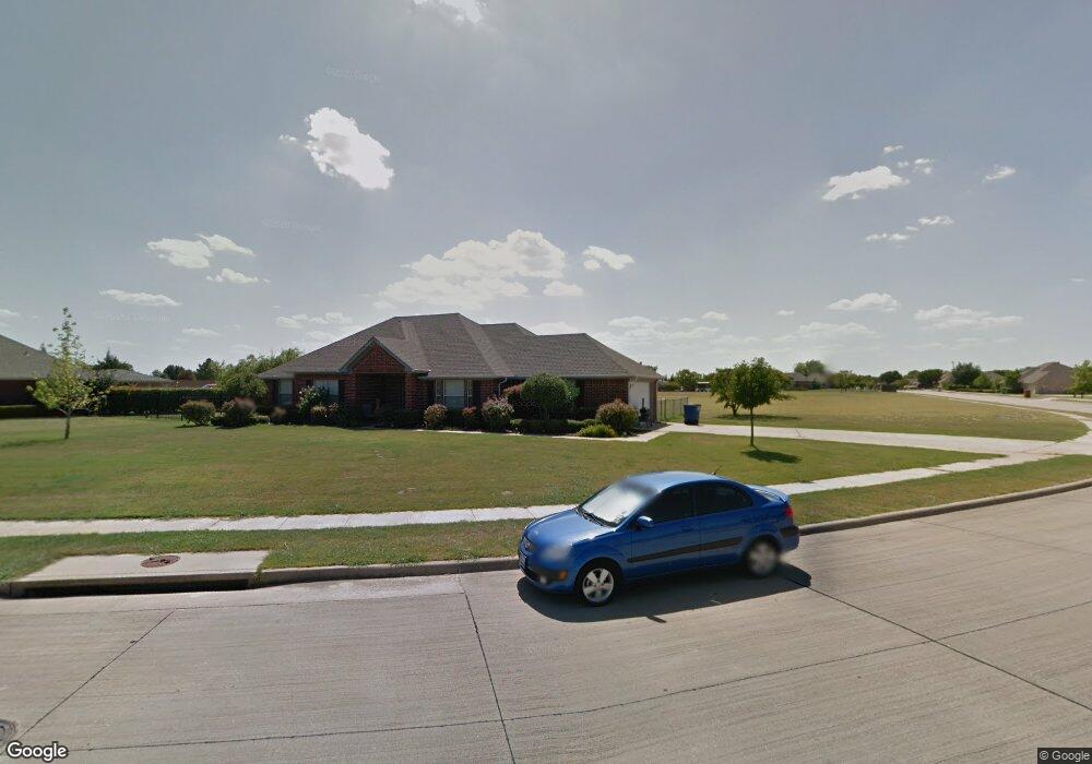
This home is located at 620 Rockspring Dr, Wylie, TX 75098 and is currently estimated at $500,117, approximately $228 per square foot. 620 Rockspring Dr is a home located in Collin County with nearby schools including R F Hartman Elementary School, AB Harrison Intermediate School, and Grady Burnett J High School.
Ownership History
Date
Name
Owned For
Owner Type
Purchase Details
Closed on
Sep 23, 2005
Sold by
Mortgage Electronic Registration Systems
Bought by
Rose Marshall L and Rose Susan E
Current Estimated Value
Home Financials for this Owner
Home Financials are based on the most recent Mortgage that was taken out on this home.
Original Mortgage
$126,000
Outstanding Balance
$71,666
Interest Rate
6.87%
Mortgage Type
Stand Alone First
Estimated Equity
$428,451
Purchase Details
Closed on
Feb 1, 2005
Sold by
Potter Gregory A and Potter Misty M
Bought by
Mortgage Electronic Registration Systems
Purchase Details
Closed on
Apr 18, 2000
Sold by
Goff Homes Inc
Bought by
Potter Gregory A and Potter Misty M
Home Financials for this Owner
Home Financials are based on the most recent Mortgage that was taken out on this home.
Original Mortgage
$148,211
Interest Rate
8.21%
Create a Home Valuation Report for This Property
The Home Valuation Report is an in-depth analysis detailing your home's value as well as a comparison with similar homes in the area
Home Values in the Area
Average Home Value in this Area
Purchase History
| Date | Buyer | Sale Price | Title Company |
|---|---|---|---|
| Rose Marshall L | -- | -- | |
| Mortgage Electronic Registration Systems | $120,000 | -- | |
| Potter Gregory A | -- | -- |
Source: Public Records
Mortgage History
| Date | Status | Borrower | Loan Amount |
|---|---|---|---|
| Open | Rose Marshall L | $126,000 | |
| Previous Owner | Potter Gregory A | $148,211 | |
| Closed | Rose Marshall L | $31,500 |
Source: Public Records
Tax History Compared to Growth
Tax History
| Year | Tax Paid | Tax Assessment Tax Assessment Total Assessment is a certain percentage of the fair market value that is determined by local assessors to be the total taxable value of land and additions on the property. | Land | Improvement |
|---|---|---|---|---|
| 2025 | $8,314 | $489,714 | $135,000 | $354,714 |
| 2024 | $8,314 | $488,485 | $135,000 | $385,743 |
| 2023 | $8,314 | $444,077 | $135,000 | $309,882 |
| 2022 | $8,256 | $403,706 | $135,000 | $360,111 |
| 2021 | $8,635 | $367,005 | $90,000 | $277,005 |
| 2020 | $8,436 | $339,746 | $70,000 | $269,746 |
| 2019 | $8,336 | $317,227 | $70,000 | $283,299 |
| 2018 | $7,492 | $278,204 | $70,000 | $251,797 |
| 2017 | $6,811 | $283,533 | $60,000 | $223,533 |
| 2016 | $6,388 | $247,459 | $60,000 | $187,459 |
| 2015 | $5,518 | $209,019 | $48,000 | $161,019 |
Source: Public Records
Map
Nearby Homes
- 825 Forest Edge Ln
- 811 Forest Edge Ln
- 1201 E Stone Rd
- 820 Foxwood Ln
- 825 Foxwood Ln
- 1210 Iron Horse St
- 216 Cedar Ridge St
- 306 Foxwood Ct
- 409 Cedar Ridge Dr
- 416 Dogwood Dr
- 414 Briarwood Dr
- 104 Rushcreek Dr
- 306 Woodhollow Ct
- 800 Twin Oaks Dr
- 1318 Chestnut Hill Dr
- 1320 Cedar Branch Dr
- 327 S 4th St
- 1209 Surrey Cir
- 300 Woodhollow Ct
- 312 Maltese Cir
- 640 Rockspring Dr
- 621 Rockspring Dr
- 930 Crestview Ln
- 920 Crestview Ln
- 601 Rockspring Cir
- 600 Rockspring Cir
- 631 Rockspring Dr
- 910 Crestview Ln
- 631 Stoneridge Dr
- 641 Rockspring Dr
- 610 Rockspring Cir
- 621 Stoneridge Dr
- 900 Crestview Ln
- 651 Rockspring Dr
- 950 Oakbrook Dr
- 940 Oakbrook Dr
- 851 Crestview Ln
- 930 Oakbrook Dr
- 641 Stoneridge Dr
- 850 Crestview Ln