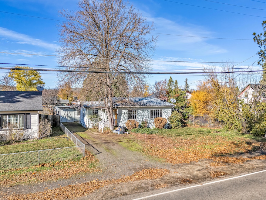
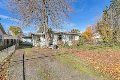
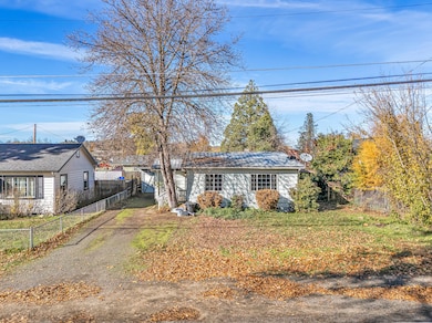
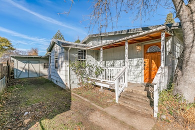
620 S Royal Ave Eagle Point, OR 97524
Estimated payment $1,480/month
Highlights
- Traditional Architecture
- Cooling Available
- Tile Flooring
- No HOA
- Bathtub with Shower
- 1-Story Property
About This Home
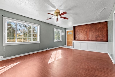
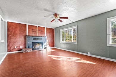
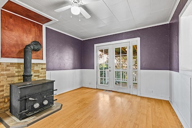
Located just minutes from parks, schools and downtown Eagle Point, this charming property offers tremendous opportunity for anyone with imagination. Fantastic investor or flip opportunity, this home sits on a big lot with large front and back garden and offers solid bones with a metal roof, wood siding, vinyl windows, and great potential. Inviting covered porch entry, tile flooring, living room with wood fireplace, and dining area with a second wood stove and access to a covered side garden. Kitchen has tile counters, wood cabinets, a glass top range, stainless steel microwave and additional storage. Two bedrooms and a full bath sit off the hall, which leads to a large bonus room that could become a game room, extra living space, or a large primary suite with walk-in closet. The back garden is roomy and ready for upgrades. Long driveway leads to an attached single car garage ideal for storage or a small shop. This is a great chance to bring your tools and update a home with real upside
Listing Agent
John L. Scott Medford Brokerage Phone: 5418402992 License #200112030 Listed on: 11/19/2025

Home Details
Home Type
- Single Family
Est. Annual Taxes
- $1,807
Year Built
- Built in 1951
Lot Details
- 8,276 Sq Ft Lot
- Zoning described as R-2
Parking
- Gravel Driveway
Home Design
- Traditional Architecture
- Frame Construction
- Metal Roof
- Concrete Perimeter Foundation
Interior Spaces
- 1,464 Sq Ft Home
- 1-Story Property
- Wood Burning Fireplace
- Vinyl Clad Windows
- Living Room with Fireplace
Kitchen
- Oven
- Range
- Microwave
- Dishwasher
- Disposal
Flooring
- Carpet
- Laminate
- Tile
Bedrooms and Bathrooms
- 3 Bedrooms
- 1 Full Bathroom
- Bathtub with Shower
Home Security
- Carbon Monoxide Detectors
- Fire and Smoke Detector
Schools
- Hillside Elementary School
- Eagle Point Middle School
- Eagle Point High School
Utilities
- Cooling Available
- Heating Available
Community Details
- No Home Owners Association
Listing and Financial Details
- Tax Lot 7000
- Assessor Parcel Number 10210716
Map
Home Values in the Area
Average Home Value in this Area
Tax History
| Year | Tax Paid | Tax Assessment Tax Assessment Total Assessment is a certain percentage of the fair market value that is determined by local assessors to be the total taxable value of land and additions on the property. | Land | Improvement |
|---|---|---|---|---|
| 2026 | $1,807 | $132,790 | -- | -- |
| 2025 | $1,764 | $128,930 | $61,730 | $67,200 |
| 2024 | $1,764 | $125,180 | $59,930 | $65,250 |
| 2023 | $1,704 | $121,540 | $58,190 | $63,350 |
| 2022 | $1,658 | $121,540 | $58,190 | $63,350 |
| 2021 | $1,609 | $118,000 | $56,500 | $61,500 |
| 2020 | $1,709 | $114,570 | $54,860 | $59,710 |
| 2019 | $1,683 | $108,000 | $51,720 | $56,280 |
| 2018 | $1,651 | $104,860 | $50,220 | $54,640 |
| 2017 | $1,611 | $104,860 | $50,220 | $54,640 |
| 2016 | $1,579 | $98,850 | $47,340 | $51,510 |
| 2015 | $1,528 | $98,850 | $47,340 | $51,510 |
| 2014 | $1,472 | $93,190 | $44,620 | $48,570 |
Property History
| Date | Event | Price | List to Sale | Price per Sq Ft |
|---|---|---|---|---|
| 04/09/2026 04/09/26 | Pending | -- | -- | -- |
| 03/30/2026 03/30/26 | Price Changed | $249,000 | -2.4% | $170 / Sq Ft |
| 12/03/2025 12/03/25 | Price Changed | $255,000 | -3.8% | $174 / Sq Ft |
| 11/19/2025 11/19/25 | For Sale | $265,000 | -- | $181 / Sq Ft |
Purchase History
| Date | Type | Sale Price | Title Company |
|---|---|---|---|
| Warranty Deed | $181,000 | Chicago Title | |
| Interfamily Deed Transfer | -- | None Available | |
| Warranty Deed | $15,633 | Jackson County Title |
Source: Oregon Datashare
MLS Number: 220212134
APN: 10210716
Disclaimer: Certain information contained herein is derived from information provided by parties other than Homes.com. All information provided is deemed reliable, but is not guaranteed to be accurate and should be independently verified.
![]() © 2026 Oregon Datashare (KCAR | MLSCO | SOMLS). All rights reserved. The data relating to real estate for sale on this web site comes in part from the Internet Data Exchange Program of the Oregon Datashare. Real estate listings held by IDX Brokerage firms other than Ten-X are marked with the Internet Data Exchange logo or the Internet Data Exchange thumbnail logo and detailed information about them includes the name of the listing Brokers. Information provided is for consumers' personal, non-commercial use and may not be used for any purpose other than to identify prospective properties the viewer may be interested in purchasing. The consumer will not copy, retransmit nor redistribute any of the content from this website. Information provided is deemed reliable, but not guaranteed.
© 2026 Oregon Datashare (KCAR | MLSCO | SOMLS). All rights reserved. The data relating to real estate for sale on this web site comes in part from the Internet Data Exchange Program of the Oregon Datashare. Real estate listings held by IDX Brokerage firms other than Ten-X are marked with the Internet Data Exchange logo or the Internet Data Exchange thumbnail logo and detailed information about them includes the name of the listing Brokers. Information provided is for consumers' personal, non-commercial use and may not be used for any purpose other than to identify prospective properties the viewer may be interested in purchasing. The consumer will not copy, retransmit nor redistribute any of the content from this website. Information provided is deemed reliable, but not guaranteed.
- 621 S Shasta Ave
- 650 Sarah Ln
- 407 S Shasta Ave
- 133 Edith Cir
- 522 Meadow Ln
- 0 Crater Lake Hwy
- 71 Tracy Ave Unit 71 & 73
- 888 Arrowhead Trail
- 10569 Hannon Rd
- 936 Arrowhead Trail
- 421 Stevens Rd Unit 20
- 421 Stevens Rd Unit 14
- 421 Stevens Rd Unit 52
- 964 Pumpkin Ridge
- 250 Tierra Cir
- 1065 S Shasta Ave
- 997 Arrowhead Trail
- 995 Pumpkin Ridge
- 1288 S Shasta Ave
- 142 Onyx St
Ask me questions while you tour the home.