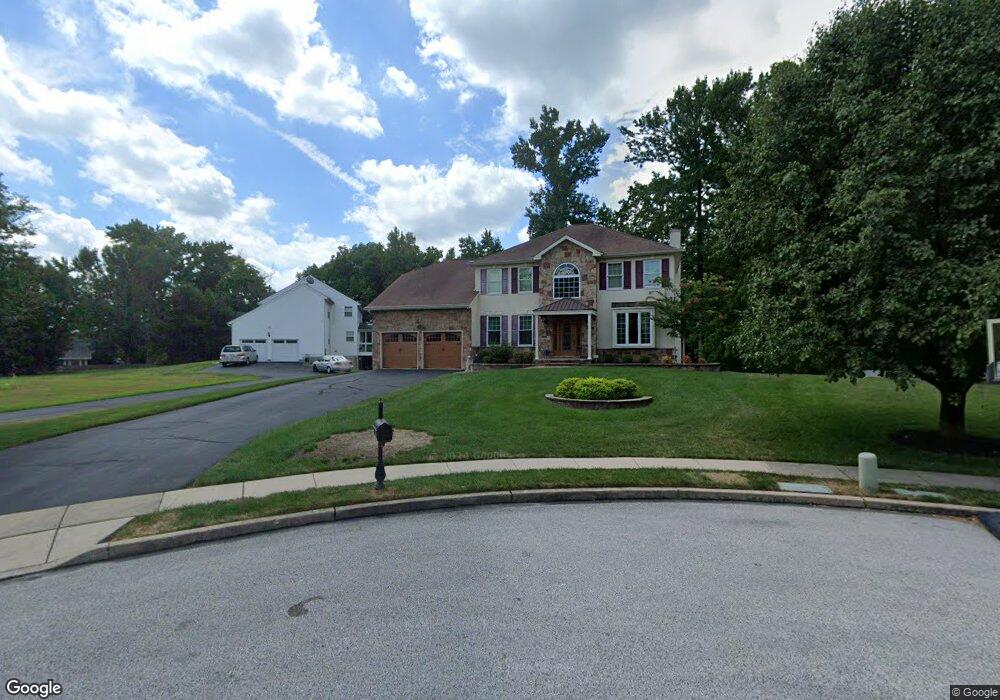
620 Sawtree Ln Bensalem, PA 19020
Estimated Value: $531,000 - $765,000
4
Beds
3
Baths
3,098
Sq Ft
$221/Sq Ft
Est. Value
About This Home
This home is located at 620 Sawtree Ln, Bensalem, PA 19020 and is currently estimated at $683,657, approximately $220 per square foot. 620 Sawtree Ln is a home located in Bucks County with nearby schools including Robert K. Shafer Middle School, St Charles Borromeo School, and Nazareth Academy Grade School.
Ownership History
Date
Name
Owned For
Owner Type
Purchase Details
Closed on
Apr 12, 2017
Sold by
Skibiszewski Walter John and Recupido Maria Michele
Bought by
Recupido Maria Michele
Current Estimated Value
Purchase Details
Closed on
Jul 6, 2006
Sold by
Skibiszewski Walter J and Recupido Maria Michelle
Bought by
Skibiszewski Walter J and Recupido Maria Michelle
Purchase Details
Closed on
Aug 30, 2002
Sold by
Skibiszewski Walter J and Recupido Maria Michele
Bought by
Skibiszewski Walter J and Recupido Maria Michele
Create a Home Valuation Report for This Property
The Home Valuation Report is an in-depth analysis detailing your home's value as well as a comparison with similar homes in the area
Home Values in the Area
Average Home Value in this Area
Purchase History
| Date | Buyer | Sale Price | Title Company |
|---|---|---|---|
| Recupido Maria Michele | -- | Assurance Abstract Corp | |
| Skibiszewski Walter J | -- | None Available | |
| Skibiszewski Walter J | -- | -- |
Source: Public Records
Tax History Compared to Growth
Tax History
| Year | Tax Paid | Tax Assessment Tax Assessment Total Assessment is a certain percentage of the fair market value that is determined by local assessors to be the total taxable value of land and additions on the property. | Land | Improvement |
|---|---|---|---|---|
| 2025 | $8,915 | $40,840 | $8,760 | $32,080 |
| 2024 | $8,915 | $40,840 | $8,760 | $32,080 |
| 2023 | $8,664 | $40,840 | $8,760 | $32,080 |
| 2022 | $8,613 | $40,840 | $8,760 | $32,080 |
| 2021 | $8,613 | $40,840 | $8,760 | $32,080 |
| 2020 | $8,527 | $40,840 | $8,760 | $32,080 |
| 2019 | $8,336 | $40,840 | $8,760 | $32,080 |
| 2018 | $8,143 | $40,840 | $8,760 | $32,080 |
| 2017 | $8,092 | $40,840 | $8,760 | $32,080 |
| 2016 | $8,092 | $40,840 | $8,760 | $32,080 |
| 2015 | -- | $40,840 | $8,760 | $32,080 |
| 2014 | -- | $40,840 | $8,760 | $32,080 |
Source: Public Records
Map
Nearby Homes
- 827 Mitchell Ave
- 1039 Clinton Ave
- 1103 Colonial Ave
- 1080 Buttonwood Ave
- 1202 Clinton Ave
- 4161 Orchard Ln
- 3727 Pitt Place
- 1126 Evelyn Ave
- 3750 Clarendon Ave Unit 3
- 3750 00 Clarendon Unit 221
- 3726 Clarendon Ave
- 3720 Clarendon Ave
- 3624 E Crown Ave
- 1236 Whittier Ave
- 3994 Constance Rd
- 3627 N Hereford Ln
- 3609 Essex Ln
- 3623 N Hereford Ln
- 124 Meadow Ln
- 4953 Fitler St Units #K & #L
- 630 Sawtree Ln
- 610 Sawtree Ln
- 600 Sawtree Ln
- 629 Locust Ave
- 615 Locust Ave
- 643 Locust Ave
- 621 Sawtree Ln
- 601 Sawtree Ln
- 630 Locust Ave
- 841 Village Ln
- 845 Village Ln
- 616 Locust Ave
- 611 Sawtree Ln
- 549 Locust Ave
- 640 Locust Ave
- 650 Locust Ave
- TBD Locust Ave
- 615 Edgewood Ave
- 615 Edgewood Ave Unit E
- 539 Locust Ave