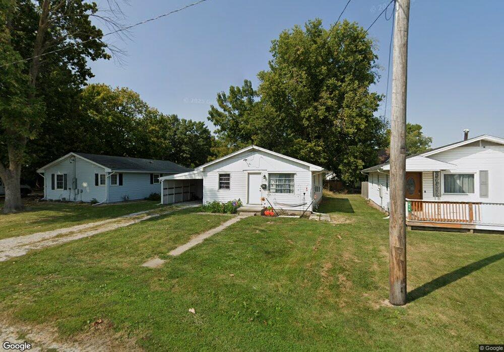
620 W Adams St Sullivan, IL 61951
Estimated Value: $97,000 - $122,000
3
Beds
1
Bath
1,040
Sq Ft
$101/Sq Ft
Est. Value
About This Home
This home is located at 620 W Adams St, Sullivan, IL 61951 and is currently estimated at $105,171, approximately $101 per square foot. 620 W Adams St is a home located in Moultrie County with nearby schools including Sullivan Elementary School, Sullivan Middle School, and Sullivan High School.
Ownership History
Date
Name
Owned For
Owner Type
Purchase Details
Closed on
Sep 22, 2020
Sold by
Barker Curtis and Barker Bryan
Bought by
Hudson Katelyn M
Current Estimated Value
Home Financials for this Owner
Home Financials are based on the most recent Mortgage that was taken out on this home.
Original Mortgage
$38,000
Outstanding Balance
$33,864
Interest Rate
3.13%
Mortgage Type
New Conventional
Estimated Equity
$71,307
Create a Home Valuation Report for This Property
The Home Valuation Report is an in-depth analysis detailing your home's value as well as a comparison with similar homes in the area
Home Values in the Area
Average Home Value in this Area
Purchase History
| Date | Buyer | Sale Price | Title Company |
|---|---|---|---|
| Hudson Katelyn M | $40,000 | None Available |
Source: Public Records
Mortgage History
| Date | Status | Borrower | Loan Amount |
|---|---|---|---|
| Open | Hudson Katelyn M | $38,000 |
Source: Public Records
Tax History
| Year | Tax Paid | Tax Assessment Tax Assessment Total Assessment is a certain percentage of the fair market value that is determined by local assessors to be the total taxable value of land and additions on the property. | Land | Improvement |
|---|---|---|---|---|
| 2024 | $1,595 | $23,239 | $1,447 | $21,792 |
| 2023 | $1,459 | $21,819 | $1,359 | $20,460 |
| 2022 | $1,438 | $21,619 | $3,002 | $18,617 |
| 2021 | $1,373 | $20,554 | $2,854 | $17,700 |
| 2020 | $1,866 | $19,737 | $2,741 | $16,996 |
| 2019 | $1,855 | $19,846 | $2,693 | $17,153 |
| 2018 | $1,582 | $16,867 | $1,369 | $15,498 |
| 2017 | $1,590 | $16,802 | $1,364 | $15,438 |
| 2016 | $1,667 | $16,839 | $1,367 | $15,472 |
| 2015 | $1,044 | $16,510 | $1,340 | $15,170 |
| 2014 | -- | $16,430 | $1,370 | $15,060 |
| 2013 | -- | $16,430 | $1,370 | $15,060 |
Source: Public Records
Map
Nearby Homes
- 21 Seth Dunscomb Dr
- 114 N Fuller St
- 521 S Catalpa St
- 520 N Camfield St
- 612 S Hope Ln
- 407 N Main St
- 716 N Seymour St
- 304 E Jackson St
- 919 S Van Buren St
- 929 S Washington St
- 1023 S Washington St
- 20 Pifers Ln
- 1650 & 1660 S Patterson Rd
- 17 Roley Estates
- 1046 State 32 Hwy
- 974 Cr 1300e
- 974 County Road 1300e
- 67 South Shores
- 122 South Shores
- 58 S Shores
- 616 W Adams St
- 116 S Grant St
- 607 W Jefferson St
- 110 S Grant St
- 601 W Jefferson St
- 0 W Adams St
- 705 W Jefferson St
- 514 W Adams St
- 515 W Jefferson St
- 709 W Jefferson St
- 704 W Jefferson St
- 622 W Jefferson St
- 13 S Mcclellan St
- 509 W Jefferson St
- 715 W Jefferson St
- 113 S Seymour St
- 503 W Jefferson St
- 603 W Harrison St
- 712 W Jefferson St
- 721 W Jefferson St
Your Personal Tour Guide
Ask me questions while you tour the home.