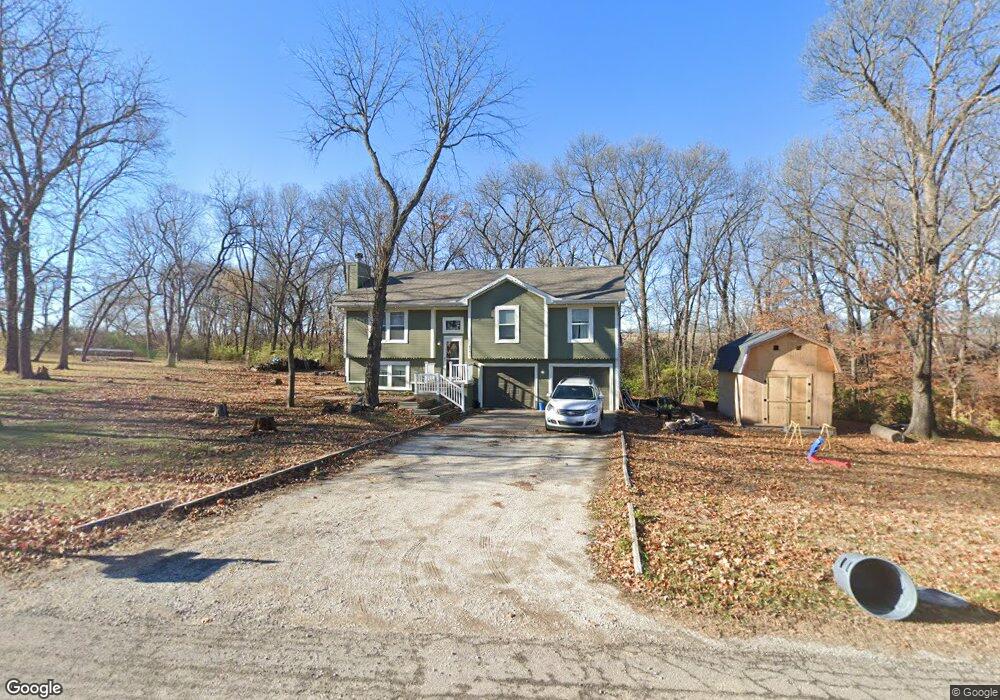
6202 SW Reed Ln Trimble, MO 64492
Estimated Value: $302,000 - $365,000
3
Beds
2
Baths
1,194
Sq Ft
$275/Sq Ft
Est. Value
About This Home
This home is located at 6202 SW Reed Ln, Trimble, MO 64492 and is currently estimated at $328,601, approximately $275 per square foot. 6202 SW Reed Ln is a home located in Clinton County with nearby schools including Ellis Elementary School, Clinton County R-III Middle School, and Plattsburg High School.
Ownership History
Date
Name
Owned For
Owner Type
Purchase Details
Closed on
Sep 23, 2020
Sold by
Hansen and Shannon
Bought by
Newman Joshua
Current Estimated Value
Home Financials for this Owner
Home Financials are based on the most recent Mortgage that was taken out on this home.
Original Mortgage
$168,000
Outstanding Balance
$149,089
Interest Rate
2.9%
Mortgage Type
Construction
Estimated Equity
$179,512
Purchase Details
Closed on
Sep 1, 2003
Bought by
Hansen Keith and Hansen Shannon
Create a Home Valuation Report for This Property
The Home Valuation Report is an in-depth analysis detailing your home's value as well as a comparison with similar homes in the area
Home Values in the Area
Average Home Value in this Area
Purchase History
| Date | Buyer | Sale Price | Title Company |
|---|---|---|---|
| Newman Joshua | $210,000 | Stewart Title | |
| Hansen Keith | -- | -- |
Source: Public Records
Mortgage History
| Date | Status | Borrower | Loan Amount |
|---|---|---|---|
| Open | Newman Joshua | $168,000 |
Source: Public Records
Tax History Compared to Growth
Tax History
| Year | Tax Paid | Tax Assessment Tax Assessment Total Assessment is a certain percentage of the fair market value that is determined by local assessors to be the total taxable value of land and additions on the property. | Land | Improvement |
|---|---|---|---|---|
| 2023 | $2,120 | $31,653 | $6,939 | $24,714 |
| 2022 | $1,983 | $29,407 | $6,939 | $22,468 |
| 2021 | $1,964 | $29,407 | $6,939 | $22,468 |
| 2020 | $1,799 | $26,733 | $6,308 | $20,425 |
| 2019 | $1,792 | $26,733 | $6,308 | $20,425 |
| 2018 | $1,792 | $26,733 | $6,308 | $20,425 |
| 2017 | $1,788 | $26,733 | $6,308 | $20,425 |
| 2016 | $1,812 | $26,733 | $6,308 | $20,425 |
| 2013 | -- | $26,730 | $0 | $0 |
Source: Public Records
Map
Nearby Homes
- 6009 SW Walnut Cove
- 0 SW Karen Rd
- Lot 1, 2 Z Hwy
- Lot 1 Unit 2 Z Highway
- 8894 Ssr-Z Hwy
- 8894 SW Highway Z
- Lot 2 Z Hwy
- 7127 SW Karen Rd
- Lot 5 Z Hwy
- 14 Howard Rd
- Lot 3 Z Hwy
- 10A Highway 169
- 206 Main St
- 501 Port Arthur Rd
- 228 E Oak St
- 9750 SW 200th St
- 339 E Oak St
- 7586 U S 169
- 3815 Highway Z
- 6320 NE 164th St
- 6202 SW Reed Ln
- 6320 SW Reed Ln
- 5988 SW Reed Ln
- 6157 SW Reed Ln
- 6313 SW Reed Ln
- 5899 SW Reed Ln
- 6204 SW Walnut Cove
- 5982 SW Walnut Cove
- 6306 SW Walnut Cove
- 6000 SW Walnut Cove
- 5874 SW Walnut Cove
- 6311 SW Walnut Cove
- 6207 SW Walnut Cove
- 5801 SW Reed Ln
- 5794 SW Reed Ln
- 5852 SW Walnut Cove
- 5987 SW Walnut Cove
- 5751 SW Reed Ln
- 6379 SW Reed Ln
- 5832 SW Maple Ridge