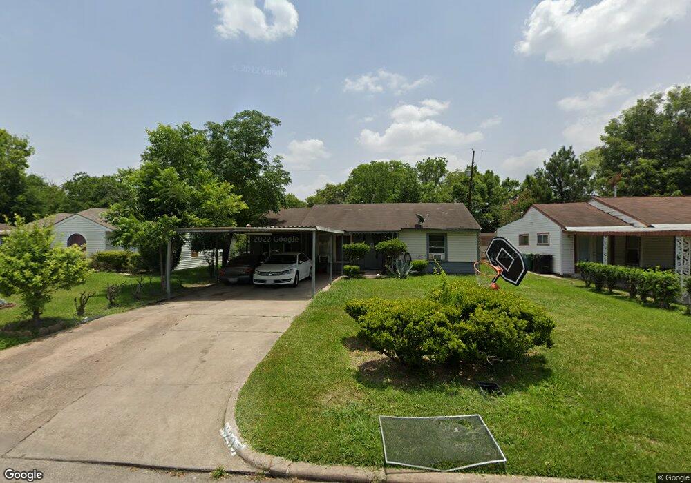
6207 Sherwood Dr Houston, TX 77021
OST-South Union NeighborhoodEstimated Value: $150,095 - $190,000
2
Beds
1
Bath
1,084
Sq Ft
$154/Sq Ft
Est. Value
About This Home
This home is located at 6207 Sherwood Dr, Houston, TX 77021 and is currently estimated at $166,524, approximately $153 per square foot. 6207 Sherwood Dr is a home located in Harris County with nearby schools including Peck Elementary School, Cullen Middle School, and Yates High School.
Ownership History
Date
Name
Owned For
Owner Type
Purchase Details
Closed on
Oct 10, 2025
Sold by
Heaven Dream Homes Llc
Bought by
St Global Ventures Llc
Current Estimated Value
Purchase Details
Closed on
Jul 29, 2025
Sold by
Osborne Clarence and Mosley Sheryl
Bought by
Heaven Dream Homes Llc
Home Financials for this Owner
Home Financials are based on the most recent Mortgage that was taken out on this home.
Original Mortgage
$139,500
Interest Rate
6.81%
Mortgage Type
Construction
Create a Home Valuation Report for This Property
The Home Valuation Report is an in-depth analysis detailing your home's value as well as a comparison with similar homes in the area
Home Values in the Area
Average Home Value in this Area
Purchase History
| Date | Buyer | Sale Price | Title Company |
|---|---|---|---|
| St Global Ventures Llc | -- | American Title Company | |
| Heaven Dream Homes Llc | -- | None Listed On Document |
Source: Public Records
Mortgage History
| Date | Status | Borrower | Loan Amount |
|---|---|---|---|
| Previous Owner | Heaven Dream Homes Llc | $139,500 |
Source: Public Records
Tax History Compared to Growth
Tax History
| Year | Tax Paid | Tax Assessment Tax Assessment Total Assessment is a certain percentage of the fair market value that is determined by local assessors to be the total taxable value of land and additions on the property. | Land | Improvement |
|---|---|---|---|---|
| 2025 | $3,253 | $145,871 | $98,865 | $47,006 |
| 2024 | $3,253 | $155,487 | $98,865 | $56,622 |
| 2023 | $3,253 | $151,857 | $98,865 | $52,992 |
| 2022 | $2,864 | $130,070 | $76,895 | $53,175 |
| 2021 | $2,395 | $102,771 | $49,433 | $53,338 |
| 2020 | $2,007 | $82,871 | $32,955 | $49,916 |
| 2019 | $1,770 | $69,957 | $27,463 | $42,494 |
| 2018 | $1,512 | $59,765 | $21,970 | $37,795 |
| 2017 | $1,511 | $59,765 | $21,970 | $37,795 |
| 2016 | $1,321 | $52,242 | $21,970 | $30,272 |
| 2015 | $965 | $50,090 | $21,970 | $28,120 |
| 2014 | $965 | $37,520 | $13,731 | $23,789 |
Source: Public Records
Map
Nearby Homes
- 3939 Tristan St
- 4015 Porter St
- 6202 Conley St
- 3931 Zephyr St
- 4101 Dixie Dr
- 4103 Dixie Dr
- 4209 Short St
- 5920 Conley St
- 3922 Alsace St
- 5908 Saint Augustine St Unit B
- 5908 Saint Augustine St Unit C
- 0 Conley St
- 6019 England St
- 6208 Sidney St
- 6135 Sidney St
- 6405 Conley St
- 6417 Saint Augustine St
- 0 Mt Pleasant St Unit 30800007
- 4520 Yellowstone Blvd
- 0 Stearns Unit 28305136
- 6203 Sherwood Dr
- 6211 Sherwood Dr
- 6119 Sherwood Dr
- 6215 Sherwood Dr
- 6206 Sherwood Dr
- 6202 Sherwood Dr
- 6210 Sherwood Dr
- 6122 Saint Augustine St Unit 1
- 6223 Sherwood Dr
- 6111 Sherwood Dr
- 3938 Tolnay St
- 6110 Saint Augustine St
- 6116 Sherwood Dr
- 6202 Saint Augustine St
- 6222 Sherwood Dr
- 6227 Sherwood Dr
- 6107 Sherwood Dr
- 6204 Saint Augustine St Unit 1
- 3934 Tolnay St
- 3935 Tristan St