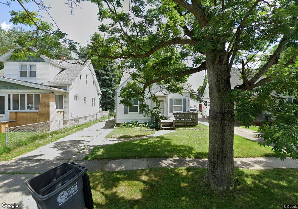
621 Barclay Dr Toledo, OH 43609
Southside NeighborhoodEstimated Value: $91,975 - $125,000
2
Beds
1
Bath
1,298
Sq Ft
$81/Sq Ft
Est. Value
About This Home
This home is located at 621 Barclay Dr, Toledo, OH 43609 and is currently estimated at $105,494, approximately $81 per square foot. 621 Barclay Dr is a home located in Lucas County with nearby schools including Burroughs Elementary School, Bowsher High School, and Explorers Academy of Science and Technology.
Ownership History
Date
Name
Owned For
Owner Type
Purchase Details
Closed on
Mar 26, 2004
Sold by
Lehman Andrew J and Lehman Amy R
Bought by
Rogers Jennifer Lynn
Current Estimated Value
Home Financials for this Owner
Home Financials are based on the most recent Mortgage that was taken out on this home.
Original Mortgage
$82,300
Outstanding Balance
$38,702
Interest Rate
5.65%
Mortgage Type
Purchase Money Mortgage
Estimated Equity
$66,792
Purchase Details
Closed on
Jun 6, 1994
Sold by
Stokes Robert W
Bought by
Lehman Andrew J and Lehman Amy R
Home Financials for this Owner
Home Financials are based on the most recent Mortgage that was taken out on this home.
Original Mortgage
$56,900
Interest Rate
8.48%
Mortgage Type
New Conventional
Purchase Details
Closed on
Jun 10, 1991
Sold by
Willinger Kim T and Willinger Luann S
Create a Home Valuation Report for This Property
The Home Valuation Report is an in-depth analysis detailing your home's value as well as a comparison with similar homes in the area
Home Values in the Area
Average Home Value in this Area
Purchase History
| Date | Buyer | Sale Price | Title Company |
|---|---|---|---|
| Rogers Jennifer Lynn | $82,300 | Louisville Title Agency For | |
| Lehman Andrew J | $59,900 | -- | |
| -- | $52,500 | -- |
Source: Public Records
Mortgage History
| Date | Status | Borrower | Loan Amount |
|---|---|---|---|
| Open | Rogers Jennifer Lynn | $82,300 | |
| Previous Owner | Lehman Andrew J | $56,900 |
Source: Public Records
Tax History Compared to Growth
Tax History
| Year | Tax Paid | Tax Assessment Tax Assessment Total Assessment is a certain percentage of the fair market value that is determined by local assessors to be the total taxable value of land and additions on the property. | Land | Improvement |
|---|---|---|---|---|
| 2024 | $738 | $23,730 | $7,245 | $16,485 |
| 2023 | $1,393 | $21,455 | $4,305 | $17,150 |
| 2022 | $1,398 | $21,455 | $4,305 | $17,150 |
| 2021 | $1,432 | $21,455 | $4,305 | $17,150 |
| 2020 | $1,499 | $19,915 | $3,990 | $15,925 |
| 2019 | $1,457 | $19,915 | $3,990 | $15,925 |
| 2018 | $1,475 | $19,915 | $3,990 | $15,925 |
| 2017 | $1,499 | $19,460 | $3,885 | $15,575 |
| 2016 | $1,499 | $55,600 | $11,100 | $44,500 |
| 2015 | $1,486 | $55,600 | $11,100 | $44,500 |
| 2014 | $1,225 | $19,470 | $3,890 | $15,580 |
| 2013 | $1,225 | $19,470 | $3,890 | $15,580 |
Source: Public Records
Map
Nearby Homes
- 2828 South Ave
- 2437 Airport Hwy
- 546 Elmdale Rd
- 663 Foredale Ave
- 569 Apple Ave
- 728 Foredale Ave
- 541 Apple Ave
- 560 Williamsville Ave
- 2332 Airline Ave
- 518 Myers St
- 838 Wylie Ave
- 552 Wyman St
- 321 Mayberry St
- 1351 Bensch Dr
- 440 Somerset St
- 940 Francis Ave
- 531 Shasta Dr
- 226 Somerset St
- 1022 National Ave
- 224 S Fearing Blvd
- 625 Barclay Dr
- 617 Barclay Dr
- 629 Barclay Dr
- 611 Barclay Dr
- 633 Barclay Dr
- 637 Barclay Dr
- 2817 Airport Hwy
- 2821 Airport Hwy
- 605 Barclay Dr
- 2833 Airport Hwy
- 2809 Airport Hwy
- 641 Barclay Dr
- 622 Barclay Dr
- 626 Barclay Dr
- 2805 Airport Hwy
- 630 Barclay Dr
- 2837 Airport Hwy
- 645 Barclay Dr
- 2734 Burwell Dr
- 634 Barclay Dr