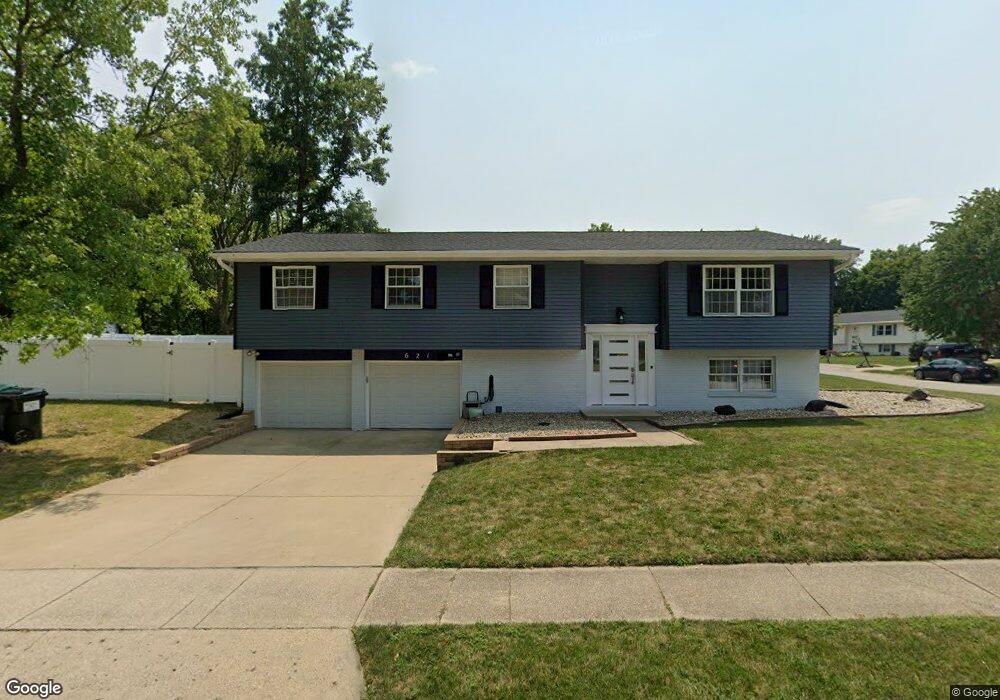
621 W Wolf Rd Decatur, IL 62526
Cresthaven NeighborhoodEstimated Value: $187,000 - $198,951
4
Beds
3
Baths
2,192
Sq Ft
$87/Sq Ft
Est. Value
About This Home
This home is located at 621 W Wolf Rd, Decatur, IL 62526 and is currently estimated at $190,988, approximately $87 per square foot. 621 W Wolf Rd is a home located in Macon County with nearby schools including Parsons Elementary School, Stephen Decatur Middle School, and Our Lady of Lourdes School.
Ownership History
Date
Name
Owned For
Owner Type
Purchase Details
Closed on
Jul 18, 2022
Sold by
Smith Mary E and Smith Andrew J
Bought by
Qatoum Maen Adeeb
Current Estimated Value
Home Financials for this Owner
Home Financials are based on the most recent Mortgage that was taken out on this home.
Original Mortgage
$121,410
Outstanding Balance
$101,656
Interest Rate
4.15%
Mortgage Type
Credit Line Revolving
Estimated Equity
$89,332
Purchase Details
Closed on
Oct 31, 2018
Sold by
Sloan Linda R
Bought by
Smith Mary E and Smith Andrew J
Home Financials for this Owner
Home Financials are based on the most recent Mortgage that was taken out on this home.
Original Mortgage
$119,225
Interest Rate
5%
Mortgage Type
New Conventional
Purchase Details
Closed on
Sep 16, 2009
Sold by
Sloan K Dale and Sloan Linda
Bought by
Sloan Linda R
Purchase Details
Closed on
Jul 1, 2001
Create a Home Valuation Report for This Property
The Home Valuation Report is an in-depth analysis detailing your home's value as well as a comparison with similar homes in the area
Home Values in the Area
Average Home Value in this Area
Purchase History
| Date | Buyer | Sale Price | Title Company |
|---|---|---|---|
| Qatoum Maen Adeeb | $135,000 | None Listed On Document | |
| Smith Mary E | $125,500 | None Available | |
| Sloan Linda R | -- | None Available | |
| -- | $115,000 | -- |
Source: Public Records
Mortgage History
| Date | Status | Borrower | Loan Amount |
|---|---|---|---|
| Open | Qatoum Maen Adeeb | $121,410 | |
| Previous Owner | Smith Mary E | $119,225 |
Source: Public Records
Tax History
| Year | Tax Paid | Tax Assessment Tax Assessment Total Assessment is a certain percentage of the fair market value that is determined by local assessors to be the total taxable value of land and additions on the property. | Land | Improvement |
|---|---|---|---|---|
| 2024 | $4,585 | $52,434 | $10,657 | $41,777 |
| 2023 | $4,251 | $48,202 | $9,797 | $38,405 |
| 2022 | $3,999 | $44,705 | $9,086 | $35,619 |
| 2021 | $3,749 | $42,138 | $8,496 | $33,642 |
| 2020 | $3,762 | $41,266 | $8,320 | $32,946 |
| 2019 | $3,762 | $41,266 | $8,320 | $32,946 |
| 2018 | $3,219 | $41,561 | $8,379 | $33,182 |
| 2017 | $3,236 | $41,792 | $8,425 | $33,367 |
| 2016 | $3,270 | $41,892 | $8,445 | $33,447 |
| 2015 | $3,109 | $41,395 | $8,345 | $33,050 |
| 2014 | $2,913 | $41,395 | $8,345 | $33,050 |
| 2013 | $2,902 | $41,395 | $8,345 | $33,050 |
Source: Public Records
Map
Nearby Homes
- 4487 Hale Dr
- 4454 Lawson Dr
- 4150 N Sunderland Dr
- 4616 Lawson Dr
- 4086 Arthur Ct
- 288 W Brown Ave
- 4051 Sheffield Dr
- 4394 Huston Hills Rd
- 0 Route 51 Unit 6241333
- 630 Montgomery Ln
- 3994 N Northbrook Dr
- 13 Lantern Ln
- 223 Crescent Dr
- 3902 Greenridge Dr
- 3931 N Newcastle Dr
- 665 Crestline Dr
- 681 W Karen Ct
- 312 W Hickory Point Rd
- 5322 Navajo Dr
- 1225 W Pineview Ct
Your Personal Tour Guide
Ask me questions while you tour the home.