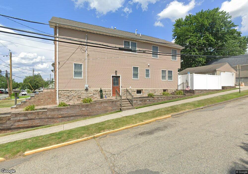
622 10th St Lyndhurst, NJ 07071
Estimated Value: $545,000 - $719,000
--
Bed
--
Bath
1,511
Sq Ft
$397/Sq Ft
Est. Value
About This Home
This home is located at 622 10th St, Lyndhurst, NJ 07071 and is currently estimated at $599,233, approximately $396 per square foot. 622 10th St is a home located in Bergen County with nearby schools including Lyndhurst High School and Sacred Heart School.
Ownership History
Date
Name
Owned For
Owner Type
Purchase Details
Closed on
Nov 20, 2000
Sold by
Horyd Joseph J
Bought by
Bonilla Justin M and Howard April M
Current Estimated Value
Home Financials for this Owner
Home Financials are based on the most recent Mortgage that was taken out on this home.
Original Mortgage
$165,300
Outstanding Balance
$60,388
Interest Rate
7.76%
Estimated Equity
$538,845
Purchase Details
Closed on
Oct 6, 2000
Bought by
Horyd Joseph
Home Financials for this Owner
Home Financials are based on the most recent Mortgage that was taken out on this home.
Original Mortgage
$165,300
Outstanding Balance
$60,388
Interest Rate
7.76%
Estimated Equity
$538,845
Create a Home Valuation Report for This Property
The Home Valuation Report is an in-depth analysis detailing your home's value as well as a comparison with similar homes in the area
Home Values in the Area
Average Home Value in this Area
Purchase History
| Date | Buyer | Sale Price | Title Company |
|---|---|---|---|
| Bonilla Justin M | $174,000 | -- | |
| Horyd Joseph | -- | -- | |
| Horyd Joseph | -- | -- |
Source: Public Records
Mortgage History
| Date | Status | Borrower | Loan Amount |
|---|---|---|---|
| Open | Bonilla Justin M | $165,300 | |
| Previous Owner | Horyd Joseph | $100,000 |
Source: Public Records
Tax History Compared to Growth
Tax History
| Year | Tax Paid | Tax Assessment Tax Assessment Total Assessment is a certain percentage of the fair market value that is determined by local assessors to be the total taxable value of land and additions on the property. | Land | Improvement |
|---|---|---|---|---|
| 2025 | $9,264 | $449,200 | $260,400 | $188,800 |
| 2024 | $8,920 | $444,100 | $257,400 | $186,700 |
| 2023 | $9,782 | $439,000 | $254,400 | $184,600 |
| 2022 | $9,782 | $308,400 | $144,300 | $164,100 |
| 2021 | $9,375 | $308,400 | $144,300 | $164,100 |
| 2020 | $9,172 | $308,400 | $144,300 | $164,100 |
| 2019 | $9,104 | $308,400 | $144,300 | $164,100 |
| 2018 | $9,178 | $308,400 | $144,300 | $164,100 |
| 2017 | $8,947 | $308,400 | $144,300 | $164,100 |
| 2016 | $8,746 | $308,400 | $144,300 | $164,100 |
| 2015 | $8,472 | $308,400 | $144,300 | $164,100 |
| 2014 | $8,361 | $308,400 | $144,300 | $164,100 |
Source: Public Records
Map
Nearby Homes