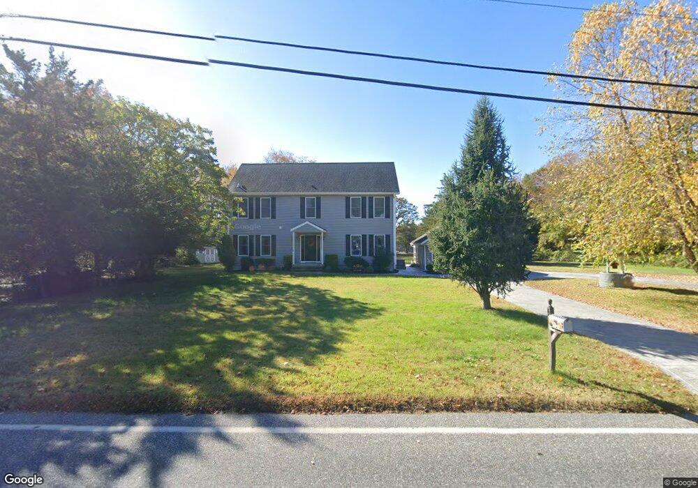
622 Jonathan Hoffman Rd Cape May, NJ 08204
Estimated Value: $616,000 - $1,308,000
--
Bed
--
Bath
2,668
Sq Ft
$376/Sq Ft
Est. Value
About This Home
This home is located at 622 Jonathan Hoffman Rd, Cape May, NJ 08204 and is currently estimated at $1,003,460, approximately $376 per square foot. 622 Jonathan Hoffman Rd is a home located in Cape May County with nearby schools including Carl T. Mitnick School, David C. Douglass Veterans Memorial School, and Maud Abrams School.
Ownership History
Date
Name
Owned For
Owner Type
Purchase Details
Closed on
Dec 8, 2011
Sold by
Haywood Denise and Drew Donna L
Bought by
Drew William F and Drew Donna L
Current Estimated Value
Purchase Details
Closed on
Oct 30, 2009
Sold by
Haywood Denise and Drew Donna L
Bought by
Haywood Denise and Drew Donna L
Purchase Details
Closed on
Mar 26, 2009
Sold by
Estate Of Lynda Valletto and Haywood Denise E
Bought by
Haywood Denise and Drew Donna L
Purchase Details
Closed on
Feb 14, 2008
Sold by
Estate Of Daniel L Valletto and Valletto Lynda
Bought by
Valletto Lynda and Drew Donna L
Create a Home Valuation Report for This Property
The Home Valuation Report is an in-depth analysis detailing your home's value as well as a comparison with similar homes in the area
Home Values in the Area
Average Home Value in this Area
Purchase History
| Date | Buyer | Sale Price | Title Company |
|---|---|---|---|
| Drew William F | $250,000 | The Title Company Of Jersey | |
| Haywood Denise | $200,000 | None Available | |
| Haywood Denise | -- | None Available | |
| Valletto Lynda | -- | None Available |
Source: Public Records
Tax History Compared to Growth
Tax History
| Year | Tax Paid | Tax Assessment Tax Assessment Total Assessment is a certain percentage of the fair market value that is determined by local assessors to be the total taxable value of land and additions on the property. | Land | Improvement |
|---|---|---|---|---|
| 2025 | $10,533 | $519,400 | $312,800 | $206,600 |
| 2024 | $10,533 | $519,400 | $312,800 | $206,600 |
| 2023 | $10,383 | $519,400 | $312,800 | $206,600 |
| 2022 | $10,066 | $519,400 | $312,800 | $206,600 |
| 2021 | $9,742 | $519,400 | $312,800 | $206,600 |
| 2020 | $9,609 | $519,400 | $312,800 | $206,600 |
| 2019 | $9,370 | $519,400 | $312,800 | $206,600 |
| 2018 | $9,147 | $519,400 | $312,800 | $206,600 |
| 2017 | $9,157 | $519,400 | $312,800 | $206,600 |
| 2016 | $9,017 | $519,400 | $312,800 | $206,600 |
| 2015 | $8,726 | $519,400 | $312,800 | $206,600 |
| 2014 | $8,440 | $519,400 | $312,800 | $206,600 |
Source: Public Records
Map
Nearby Homes
- 3941 Bayshore Rd
- 3911 Bayshore Rd
- 1024 Shunpike Rd
- 712 Gorham Ave
- 818 Shunpike Rd
- 602 Gorham Ave
- 1031 Seashore Rd
- 808 Westfield Ave
- 668 Crawford Rd
- 1036 Seashore Rd
- 54 Heron Way
- 402 Whildam Ave
- 313 Nantucket Dr
- 305 Whildam Ave
- 207 Old Mill Dr
- 753 Route 9 Unit U
- 118 Old Mill Dr
- 105 Orchard Dr
- 1062 Seashore Rd
- 507 Scotty Blvd Unit 12
- 625 Jonathan Hoffman Rd
- 623 Jonathan Hoffman Rd
- 632 Jonathan Hoffman Rd
- 631 Jonathan Hoffman Rd
- 940 Shunpike Rd
- 617 Jonathan Hoffman Rd
- 633 Jonathan Hoffman Rd
- 627 Jonathan Hoffman Rd
- 629 Jonathan Hoffman Rd
- 620 Jonathan Hoffman Rd
- 939 Shunpike Rd
- 937 Shunpike Rd
- 932 Shunpike Rd
- 611 Jonathan Hoffman Rd
- 615 Jonathan Hoffman Rd
- 928 Shunpike Rd
- 618 Jonathan Hoffman Rd
- 613 Jonathan Hoffman Rd
- 702 Jonathan Hoffman Rd
- 930 Shunpike Rd