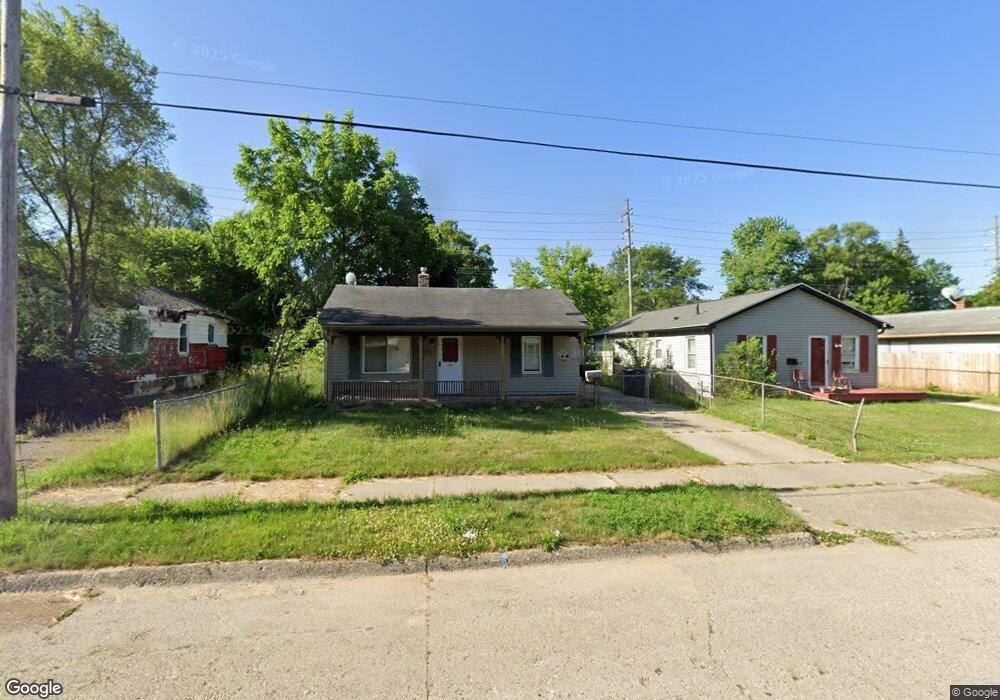
622 McKeighan Ave Flint, MI 48507
Circle Drive NeighborhoodEstimated Value: $63,550 - $81,000
2
Beds
1
Bath
952
Sq Ft
$75/Sq Ft
Est. Value
About This Home
This home is located at 622 McKeighan Ave, Flint, MI 48507 and is currently estimated at $71,638, approximately $75 per square foot. 622 McKeighan Ave is a home located in Genesee County with nearby schools including Freeman Elementary School, Flint Southwestern Classical Academy, and International Academy of Flint (K-12).
Ownership History
Date
Name
Owned For
Owner Type
Purchase Details
Closed on
Nov 2, 2007
Sold by
Vanover Ellen and Vanover William
Bought by
Federal Home Loan Mortgage Corp
Current Estimated Value
Purchase Details
Closed on
Jun 8, 2005
Sold by
Monaghan Pat R and Monaghan Prudence
Bought by
Vanover Ellen and Vanover William
Home Financials for this Owner
Home Financials are based on the most recent Mortgage that was taken out on this home.
Original Mortgage
$52,000
Interest Rate
6%
Mortgage Type
Fannie Mae Freddie Mac
Create a Home Valuation Report for This Property
The Home Valuation Report is an in-depth analysis detailing your home's value as well as a comparison with similar homes in the area
Home Values in the Area
Average Home Value in this Area
Purchase History
| Date | Buyer | Sale Price | Title Company |
|---|---|---|---|
| Federal Home Loan Mortgage Corp | $57,860 | None Available | |
| Vanover Ellen | $65,000 | Title Michigan Agency Ltd |
Source: Public Records
Mortgage History
| Date | Status | Borrower | Loan Amount |
|---|---|---|---|
| Previous Owner | Vanover Ellen | $52,000 |
Source: Public Records
Tax History Compared to Growth
Tax History
| Year | Tax Paid | Tax Assessment Tax Assessment Total Assessment is a certain percentage of the fair market value that is determined by local assessors to be the total taxable value of land and additions on the property. | Land | Improvement |
|---|---|---|---|---|
| 2025 | $1,660 | $35,700 | $0 | $0 |
| 2024 | $1,526 | $32,300 | $0 | $0 |
| 2023 | $1,482 | $29,700 | $0 | $0 |
| 2022 | $0 | $24,300 | $0 | $0 |
| 2021 | $1,508 | $21,300 | $0 | $0 |
| 2020 | $1,375 | $16,900 | $0 | $0 |
| 2019 | $1,022 | $13,200 | $0 | $0 |
| 2018 | $1,017 | $11,400 | $0 | $0 |
| 2017 | $1,083 | $0 | $0 | $0 |
| 2016 | $1,075 | $0 | $0 | $0 |
| 2015 | -- | $0 | $0 | $0 |
| 2014 | -- | $0 | $0 | $0 |
| 2012 | -- | $16,800 | $0 | $0 |
Source: Public Records
Map
Nearby Homes
- 810 Macdonald Ave
- 621 Burroughs Ave
- 4127 Custer Ave
- 4424 Cheyenne Ave
- 630 Buckingham Ave
- 4310 Cheyenne Ave
- 4205 Red Arrow Rd
- 454 E Atherton Rd
- 3343 Cheyenne Ave
- 326 Burroughs Ave
- 3614 Comanche Ave
- 3512 Barcey Ct
- 3505 Comanche Ave
- 4010 Milton Dr
- 2207 E Boatfield Ave
- 0000 E Bristol Rd
- 2130 E Whittemore Ave
- 3115 Circle Dr
- 2231 E Bergin Ave
- 2220 E Bergin Ave
- 618 McKeighan Ave
- 626 McKeighan Ave
- 614 McKeighan Ave
- 630 McKeighan Ave
- 610 McKeighan Ave
- 613 Macdonald Ave
- 609 Macdonald Ave
- 617 Macdonald Ave
- 625 McKeighan Ave
- 605 Macdonald Ave
- 629 McKeighan Ave
- 621 McKeighan Ave
- 606 McKeighan Ave
- 601 Macdonald Ave
- 617 McKeighan Ave
- 4418 Circle Dr
- 625 Macdonald Ave
- 640 McKeighan Ave
- 533 Macdonald Ave
- 602 McKeighan Ave