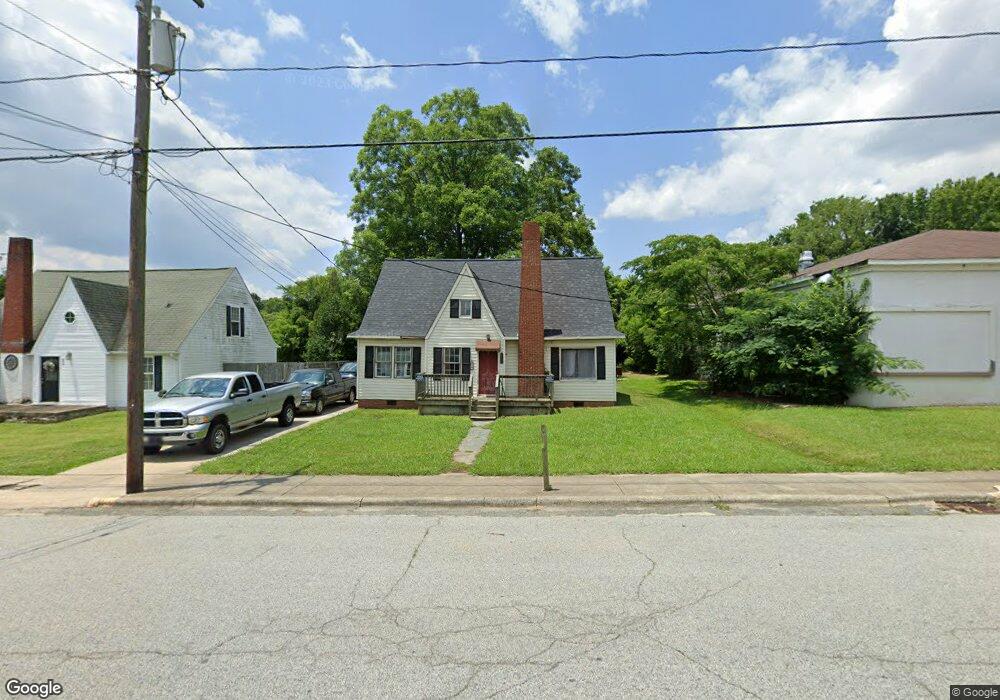
622 N Main St Denton, NC 27239
Estimated Value: $93,000 - $227,000
3
Beds
1
Bath
1,636
Sq Ft
$104/Sq Ft
Est. Value
About This Home
This home is located at 622 N Main St, Denton, NC 27239 and is currently estimated at $169,951, approximately $103 per square foot. 622 N Main St is a home located in Davidson County with nearby schools including Denton Elementary School and South Davidson Middle and High School.
Ownership History
Date
Name
Owned For
Owner Type
Purchase Details
Closed on
Jul 9, 2018
Sold by
Rentz Llc
Bought by
Eason Timothy Paul
Current Estimated Value
Purchase Details
Closed on
Mar 26, 2011
Sold by
Tysinger Steven Dale and Tysinger Heather C
Bought by
Floyd Terry
Home Financials for this Owner
Home Financials are based on the most recent Mortgage that was taken out on this home.
Original Mortgage
$37,500
Interest Rate
4.92%
Mortgage Type
Seller Take Back
Purchase Details
Closed on
Dec 5, 2007
Sold by
Smith Ken B and Hamby Ken Brooks
Bought by
Tysinger Steven Dale
Purchase Details
Closed on
Feb 1, 1997
Create a Home Valuation Report for This Property
The Home Valuation Report is an in-depth analysis detailing your home's value as well as a comparison with similar homes in the area
Home Values in the Area
Average Home Value in this Area
Purchase History
| Date | Buyer | Sale Price | Title Company |
|---|---|---|---|
| Eason Timothy Paul | $12,500 | None Available | |
| Floyd Terry | $40,000 | None Available | |
| Tysinger Steven Dale | -- | None Available | |
| -- | $10,000 | -- |
Source: Public Records
Mortgage History
| Date | Status | Borrower | Loan Amount |
|---|---|---|---|
| Previous Owner | Floyd Terry | $37,500 |
Source: Public Records
Tax History Compared to Growth
Tax History
| Year | Tax Paid | Tax Assessment Tax Assessment Total Assessment is a certain percentage of the fair market value that is determined by local assessors to be the total taxable value of land and additions on the property. | Land | Improvement |
|---|---|---|---|---|
| 2025 | $587 | $52,280 | $0 | $0 |
| 2024 | $587 | $52,280 | $0 | $0 |
| 2023 | $587 | $52,280 | $0 | $0 |
| 2022 | $587 | $52,280 | $0 | $0 |
| 2021 | $587 | $52,280 | $0 | $0 |
| 2020 | $534 | $47,550 | $0 | $0 |
| 2019 | $542 | $47,550 | $0 | $0 |
| 2018 | $542 | $47,550 | $0 | $0 |
| 2017 | $535 | $46,950 | $0 | $0 |
| 2016 | $535 | $46,950 | $0 | $0 |
| 2015 | $512 | $46,950 | $0 | $0 |
| 2014 | $549 | $50,350 | $0 | $0 |
Source: Public Records
Map
Nearby Homes
- 162 E 3rd St
- 148 Garner St
- 00 3rd St
- 249 Farmbrook Dr
- 61 Haywood St
- 00 N Carolina 47
- 434 E Salisbury St
- 240 Anderson St
- 539 W Salisbury St
- 0 Jones St
- 491 W Peacock Ave
- 191 Howell Dr
- 320 Forest Park Dr
- 952 Flat Swamp Rd
- 149 Seeley Dr
- 278 Forest Park Dr
- 572 Bombay Rd
- 0000 Bombay Rd
- 219 Dot St
- 997 Yates Rd