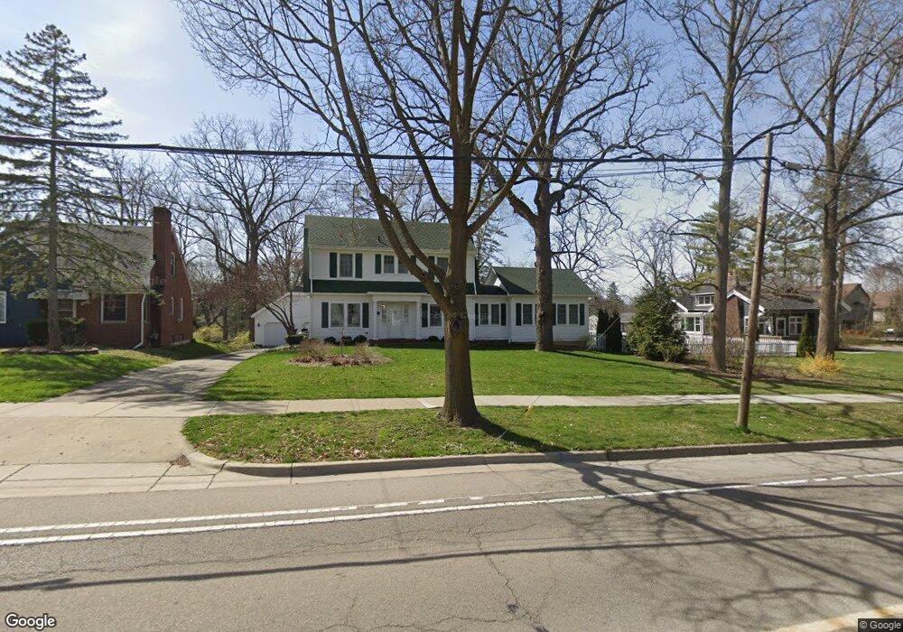
622 S 7th St Ann Arbor, MI 48103
Old West Side NeighborhoodEstimated Value: $758,903 - $1,017,000
3
Beds
4
Baths
2,371
Sq Ft
$363/Sq Ft
Est. Value
About This Home
This home is located at 622 S 7th St, Ann Arbor, MI 48103 and is currently estimated at $860,976, approximately $363 per square foot. 622 S 7th St is a home located in Washtenaw County with nearby schools including Eberwhite Elementary School, Slauson Middle School, and Pioneer High School.
Ownership History
Date
Name
Owned For
Owner Type
Purchase Details
Closed on
Apr 11, 2023
Sold by
Platte Richard L and Platte Leslie R
Bought by
Platte Richard L and Platte Richard L
Current Estimated Value
Purchase Details
Closed on
Mar 5, 2010
Sold by
Platte Richard L and Platte Leslie Rae
Bought by
The Platte Family Revocable Trust
Create a Home Valuation Report for This Property
The Home Valuation Report is an in-depth analysis detailing your home's value as well as a comparison with similar homes in the area
Home Values in the Area
Average Home Value in this Area
Purchase History
| Date | Buyer | Sale Price | Title Company |
|---|---|---|---|
| Platte Richard L | -- | None Listed On Document | |
| Platte Richard L | -- | None Listed On Document | |
| The Platte Family Revocable Trust | -- | None Available |
Source: Public Records
Tax History
| Year | Tax Paid | Tax Assessment Tax Assessment Total Assessment is a certain percentage of the fair market value that is determined by local assessors to be the total taxable value of land and additions on the property. | Land | Improvement |
|---|---|---|---|---|
| 2025 | $10,849 | $491,900 | $0 | $0 |
| 2024 | $10,582 | $452,400 | $0 | $0 |
| 2023 | $9,757 | $365,800 | $0 | $0 |
| 2022 | $10,632 | $346,100 | $0 | $0 |
| 2021 | $10,382 | $337,700 | $0 | $0 |
| 2020 | $10,172 | $337,300 | $0 | $0 |
| 2019 | $9,680 | $316,600 | $316,600 | $0 |
| 2018 | $9,544 | $288,700 | $0 | $0 |
| 2017 | $6,974 | $228,200 | $0 | $0 |
| 2016 | $6,728 | $139,450 | $0 | $0 |
| 2015 | $6,407 | $139,033 | $0 | $0 |
| 2014 | $6,407 | $134,689 | $0 | $0 |
| 2013 | -- | $134,689 | $0 | $0 |
Source: Public Records
Map
Nearby Homes
- 614 S 7th St
- 919 5th St
- 608 Soule Blvd
- 1002 W Liberty St
- 717 W Liberty St
- 220 W Mosley St
- 1405 W Liberty St
- 616 S Ashley St
- 1209 Birk Ave
- 222 Buena Vista Ave
- 1217 Birk Ave
- 1215 Prescott Ave
- 441 S Ashley St Unit 405
- 315 2nd St Unit 513
- 140 Ashley Mews Dr Unit 27
- 430 S Main St
- 404 W Liberty St
- 414 S Main St Unit 10
- 401 Berkley Ave
- 462 W Stadium Blvd
- 626 S 7th St
- 627 Madison Place
- 621 Madison Place
- 700 S 7th St
- 615 Madison Place
- 618 S 7th St
- 704 S 7th St
- 701 Madison Place
- 705 Madison Place
- 610 S 7th St
- 609 Madison Place
- 706 S 7th St
- 814 Princeton Ave
- 814 Princeton St
- 617 S 7th St
- 701 S 7th St
- 730 Madison Place
- 0 Madison Place
- 615 S 7th St
- 707 Madison Place
Your Personal Tour Guide
Ask me questions while you tour the home.