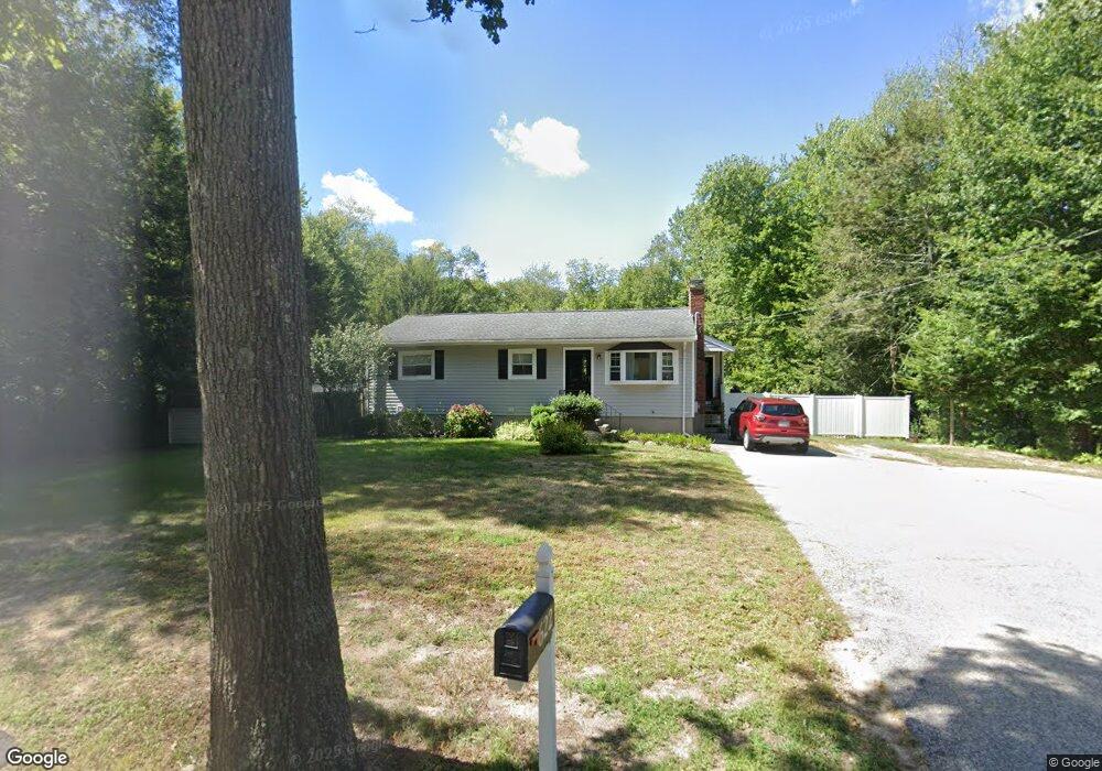
622 Whiting St Hanover, MA 02339
Estimated Value: $530,000 - $693,000
3
Beds
1
Bath
1,404
Sq Ft
$433/Sq Ft
Est. Value
About This Home
This home is located at 622 Whiting St, Hanover, MA 02339 and is currently estimated at $607,795, approximately $432 per square foot. 622 Whiting St is a home located in Plymouth County with nearby schools including Hanover High School, Calvary Chapel Academy, and Holy Family Elementary School.
Ownership History
Date
Name
Owned For
Owner Type
Purchase Details
Closed on
Dec 14, 2000
Sold by
Dao Dat Vinh and Duong P;At Ngoc
Bought by
Feeney Stephen T and Feeney Lori J
Current Estimated Value
Purchase Details
Closed on
Oct 15, 1998
Sold by
Maguire Michael F and Maguire Andrea
Bought by
Dao Dat Vinh
Purchase Details
Closed on
Jul 30, 1993
Sold by
Owens John J and Owens Carolyn M
Bought by
Maguire Michael F and Lavertue Andrea
Create a Home Valuation Report for This Property
The Home Valuation Report is an in-depth analysis detailing your home's value as well as a comparison with similar homes in the area
Home Values in the Area
Average Home Value in this Area
Purchase History
| Date | Buyer | Sale Price | Title Company |
|---|---|---|---|
| Feeney Stephen T | $215,900 | -- | |
| Dao Dat Vinh | $166,000 | -- | |
| Maguire Michael F | $132,900 | -- |
Source: Public Records
Mortgage History
| Date | Status | Borrower | Loan Amount |
|---|---|---|---|
| Open | Maguire Michael F | $82,000 | |
| Open | Maguire Michael F | $231,900 |
Source: Public Records
Tax History Compared to Growth
Tax History
| Year | Tax Paid | Tax Assessment Tax Assessment Total Assessment is a certain percentage of the fair market value that is determined by local assessors to be the total taxable value of land and additions on the property. | Land | Improvement |
|---|---|---|---|---|
| 2025 | $6,638 | $537,500 | $270,700 | $266,800 |
| 2024 | $6,902 | $537,500 | $270,700 | $266,800 |
| 2023 | $6,512 | $482,700 | $246,000 | $236,700 |
| 2022 | $6,597 | $432,600 | $246,000 | $186,600 |
| 2021 | $4,327 | $404,000 | $223,700 | $180,300 |
| 2020 | $6,508 | $399,000 | $223,700 | $175,300 |
| 2019 | $7,834 | $378,800 | $223,700 | $155,100 |
| 2018 | $6,058 | $372,100 | $223,700 | $148,400 |
| 2017 | $6,017 | $364,200 | $212,400 | $151,800 |
| 2016 | $5,815 | $344,900 | $193,100 | $151,800 |
| 2015 | $5,271 | $326,400 | $193,100 | $133,300 |
Source: Public Records
Map
Nearby Homes
- 120 Deerfield Ln
- 141 Deerfield Ln
- 206-208 Hinghm St
- 18 Midfield Dr
- 55 Turner Rd
- 18 Colby St
- 216 Whiting St
- 354 Webster St
- 436 E Water St
- 1239 Main St
- 118 Bates Way
- 80 Coolidge Rd
- 507 Liberty St
- 7 Boxberry Ln Unit 7
- 70 Dillingham Way
- 65 Boxberry Ln
- 83 Summit St
- 62 High St
- 375 Webster St
- 214 Washington St Unit 24