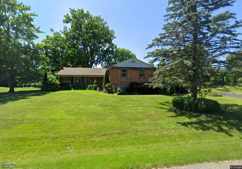
6222 Northfield Rd West Bloomfield, MI 48322
Estimated Value: $482,720 - $603,000
4
Beds
3
Baths
2,875
Sq Ft
$183/Sq Ft
Est. Value
About This Home
This home is located at 6222 Northfield Rd, West Bloomfield, MI 48322 and is currently estimated at $525,430, approximately $182 per square foot. 6222 Northfield Rd is a home located in Oakland County with nearby schools including Sheiko Elementary School, West Bloomfield Middle School, and Bloomfield Maples Montessori.
Ownership History
Date
Name
Owned For
Owner Type
Purchase Details
Closed on
Oct 31, 2017
Sold by
Eliya Zaid and Nasir Zaid
Bought by
Eliya Zaid and Eliya Hala
Current Estimated Value
Purchase Details
Closed on
Jun 15, 2009
Sold by
Schumer Michel Nancy and Estate Of Howard Sobel
Bought by
Nasir Zaid
Purchase Details
Closed on
Apr 19, 2005
Sold by
Miller Irene and Sobel Irene
Bought by
Sobel Howard Bernard
Create a Home Valuation Report for This Property
The Home Valuation Report is an in-depth analysis detailing your home's value as well as a comparison with similar homes in the area
Home Values in the Area
Average Home Value in this Area
Purchase History
| Date | Buyer | Sale Price | Title Company |
|---|---|---|---|
| Eliya Zaid | -- | None Available | |
| Nasir Zaid | $187,000 | Capital Title Ins Agency | |
| Sobel Howard Bernard | -- | -- |
Source: Public Records
Tax History Compared to Growth
Tax History
| Year | Tax Paid | Tax Assessment Tax Assessment Total Assessment is a certain percentage of the fair market value that is determined by local assessors to be the total taxable value of land and additions on the property. | Land | Improvement |
|---|---|---|---|---|
| 2024 | $3,269 | $204,400 | $0 | $0 |
| 2022 | $3,130 | $170,920 | $40,750 | $130,170 |
| 2021 | $4,757 | $162,800 | $0 | $0 |
| 2020 | $3,067 | $155,030 | $40,750 | $114,280 |
| 2018 | $4,586 | $146,600 | $40,750 | $105,850 |
| 2015 | -- | $127,940 | $0 | $0 |
| 2014 | -- | $119,170 | $0 | $0 |
| 2011 | -- | $111,070 | $0 | $0 |
Source: Public Records
Map
Nearby Homes
- 3035 Parkland Dr
- 6564 Alderley Way
- 6545 Post Oak Dr
- 6624 Mellow Wood Ln
- 6769 Heather Heath
- 6151 Orchard Lake Rd Unit 103
- 5780 Swan Lake Ct
- 5622 Powder Horn Dr
- 6145 Orchard Lake Rd Unit 204
- 6109 Orchard Lake Rd Unit 101
- 3865 Stonecrest Rd
- 7023 Wild Ridge Ln
- 3104 Spring St
- 5815 Bloomfield Glens Rd
- 6843 Leslee Crest Dr
- 6322 Pepper Hill St Unit 62
- 6222 Pepper Hill St
- 7027 Beverly Crest Dr
- 4161 Breckenridge Dr
- 4185 Pinehurst Ct
- 6200 Northfield Rd
- 6256 Northfield Rd
- 6277 Saint James Ct
- 6233 Northfield Rd
- 6205 Northfield Rd
- 6261 Saint James Ct
- 6265 Northfield Rd
- 6172 Northfield Rd
- 6301 Saint James Dr
- 6290 Northfield Rd
- 6291 Saint James Ct
- 6185 Northfield Rd
- 6090 Wynford Dr
- 6108 Wynford Dr
- 6321 Saint James Dr
- 6072 Wynford Dr
- 6251 Saint James Ct
- 6126 Wynford Dr
- 6291 Northfield Rd
- 6054 Wynford Dr