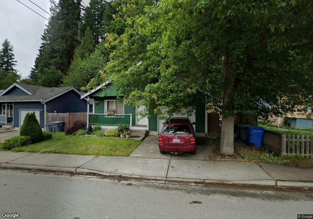
623 Railroad Ave Wilkeson, WA 98396
Estimated Value: $370,000 - $468,000
3
Beds
2
Baths
1,122
Sq Ft
$370/Sq Ft
Est. Value
About This Home
This home is located at 623 Railroad Ave, Wilkeson, WA 98396 and is currently estimated at $415,660, approximately $370 per square foot. 623 Railroad Ave is a home with nearby schools including Wilkeson Elementary School and Glacier Middle School.
Ownership History
Date
Name
Owned For
Owner Type
Purchase Details
Closed on
Feb 9, 2021
Sold by
Polston Holly Jeanine and Wells Holly
Bought by
Polston Holly Jeanine and Polston Christerpher Allen
Current Estimated Value
Home Financials for this Owner
Home Financials are based on the most recent Mortgage that was taken out on this home.
Original Mortgage
$204,000
Outstanding Balance
$182,298
Interest Rate
2.65%
Mortgage Type
New Conventional
Estimated Equity
$233,362
Purchase Details
Closed on
Apr 9, 1997
Sold by
D & K Construction Inc
Bought by
Harston Roger R and Harston Amber K
Home Financials for this Owner
Home Financials are based on the most recent Mortgage that was taken out on this home.
Original Mortgage
$102,714
Interest Rate
7.66%
Create a Home Valuation Report for This Property
The Home Valuation Report is an in-depth analysis detailing your home's value as well as a comparison with similar homes in the area
Home Values in the Area
Average Home Value in this Area
Purchase History
| Date | Buyer | Sale Price | Title Company |
|---|---|---|---|
| Polston Holly Jeanine | -- | Old Republic Title Ltd | |
| Harston Roger R | $103,400 | -- |
Source: Public Records
Mortgage History
| Date | Status | Borrower | Loan Amount |
|---|---|---|---|
| Open | Polston Holly Jeanine | $204,000 | |
| Closed | Harston Roger R | $102,714 |
Source: Public Records
Tax History Compared to Growth
Tax History
| Year | Tax Paid | Tax Assessment Tax Assessment Total Assessment is a certain percentage of the fair market value that is determined by local assessors to be the total taxable value of land and additions on the property. | Land | Improvement |
|---|---|---|---|---|
| 2025 | $2,994 | $389,500 | $168,700 | $220,800 |
| 2024 | $2,994 | $368,000 | $160,200 | $207,800 |
| 2023 | $2,994 | $341,900 | $155,200 | $186,700 |
| 2022 | $3,032 | $354,300 | $156,900 | $197,400 |
| 2021 | $2,890 | $258,500 | $111,800 | $146,700 |
| 2019 | $2,457 | $234,400 | $94,600 | $139,800 |
| 2018 | $2,320 | $227,100 | $86,000 | $141,100 |
| 2017 | $2,177 | $181,300 | $55,600 | $125,700 |
| 2016 | $1,964 | $141,600 | $33,700 | $107,900 |
| 2014 | $1,923 | $128,700 | $31,900 | $96,800 |
| 2013 | $1,923 | $110,400 | $27,300 | $83,100 |
Source: Public Records
Map
Nearby Homes
- 506 Ash St
- 151 XX Wilkeson-Spiketon Rd
- 28118 163rd St E
- 203 Albert St
- 15503 State Route 165 E
- 27209 162nd St E
- 26309 Johns Rd E
- 381 Coal Ave
- 16304 Ap Tubbs Rd E
- 181 Coal Ave
- 26712 151st St E
- 0 A P Tubbs Rd
- 14120 Washington 165
- 27210 145th St E
- 15716 A P Tubbs Rd E
- 25624 166th St E
- 13815 299th Ave E
- 25323 182nd St E
- 27511 178th St E
- 25523 157th St E