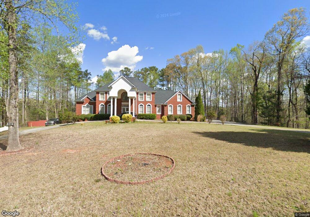
6230 Vickers Rd Fairburn, GA 30213
Estimated Value: $536,000 - $695,343
4
Beds
4
Baths
4,053
Sq Ft
$152/Sq Ft
Est. Value
About This Home
This home is located at 6230 Vickers Rd, Fairburn, GA 30213 and is currently estimated at $614,336, approximately $151 per square foot. 6230 Vickers Rd is a home located in Fulton County with nearby schools including Liberty Point Elementary School, Renaissance Middle School, and Langston Hughes High School.
Ownership History
Date
Name
Owned For
Owner Type
Purchase Details
Closed on
Dec 6, 2012
Sold by
Shelby Property Llc
Bought by
Howard Dwight David
Current Estimated Value
Purchase Details
Closed on
Jul 3, 2012
Sold by
City Of Union City
Bought by
Shelby Property
Purchase Details
Closed on
Aug 13, 2004
Sold by
Thompson Marlon M and Thompson Denise
Bought by
Howard Dwight D
Home Financials for this Owner
Home Financials are based on the most recent Mortgage that was taken out on this home.
Original Mortgage
$364,650
Interest Rate
5.96%
Mortgage Type
New Conventional
Create a Home Valuation Report for This Property
The Home Valuation Report is an in-depth analysis detailing your home's value as well as a comparison with similar homes in the area
Home Values in the Area
Average Home Value in this Area
Purchase History
| Date | Buyer | Sale Price | Title Company |
|---|---|---|---|
| Howard Dwight David | $100,000 | -- | |
| Shelby Property | -- | -- | |
| Howard Dwight D | $429,000 | -- |
Source: Public Records
Mortgage History
| Date | Status | Borrower | Loan Amount |
|---|---|---|---|
| Previous Owner | Howard Dwight D | $364,650 |
Source: Public Records
Tax History
| Year | Tax Paid | Tax Assessment Tax Assessment Total Assessment is a certain percentage of the fair market value that is determined by local assessors to be the total taxable value of land and additions on the property. | Land | Improvement |
|---|---|---|---|---|
| 2025 | $3,601 | $301,240 | $43,480 | $257,760 |
| 2023 | $8,887 | $314,840 | $36,440 | $278,400 |
| 2022 | $4,314 | $163,960 | $22,440 | $141,520 |
| 2021 | $3,809 | $140,400 | $18,760 | $121,640 |
| 2020 | $3,562 | $128,160 | $11,440 | $116,720 |
| 2019 | $5,317 | $125,880 | $11,240 | $114,640 |
| 2018 | $3,470 | $122,920 | $10,960 | $111,960 |
| 2017 | $1,438 | $49,280 | $7,080 | $42,200 |
| 2016 | $1,438 | $49,280 | $7,080 | $42,200 |
| 2015 | $2,217 | $49,280 | $7,080 | $42,200 |
| 2014 | $1,511 | $49,280 | $7,080 | $42,200 |
Source: Public Records
Map
Nearby Homes
- 5324 Radford Loop
- 7624 Squire Ct
- 0 Fireside Way Unit 10706391
- 6230 Tennis Dr
- 5699 Union Pointe Dr
- 6009 Redtop Loop
- 4422 Manor Hill Dr
- 5723 Union Pointe Dr
- 4428 Manor Hill Dr
- 3029 Manor Hill Place
- 3033 Manor Hill Place
- 1015 Avalon Terrace
- 49 Fireside Way
- 5642 Union Pointe Dr
- 5845 Union Walk Dr
- 3035 Manor Hill Place
- 7820 Marie Way
- 4458 Manor Hill Dr
- 6174 Lower Dixie Lake Rd
- 0 Lower Dixie Lake Rd Unit 26353504
- 6185 Redtop Loop
- 6181 Redtop Loop
- 6189 Redtop Loop
- 6177 Redtop Loop
- 6290 Vickers Rd
- 6193 Redtop Loop
- 6173 Redtop Loop
- 6173 Red Top Loop
- 6197 Redtop Loop
- 5901 Blacktop Way
- 6250 Vickers Rd
- 6172 Redtop Loop
- 6270 Vickers Rd
- 5901 Black Top Way
- 6169 Redtop Loop
- 5897 Black Top Way
- 5900 Blacktop Way
- 6310 Vickers Rd
- 5897 Blacktop Way
- 6164 Redtop Loop
Your Personal Tour Guide
Ask me questions while you tour the home.