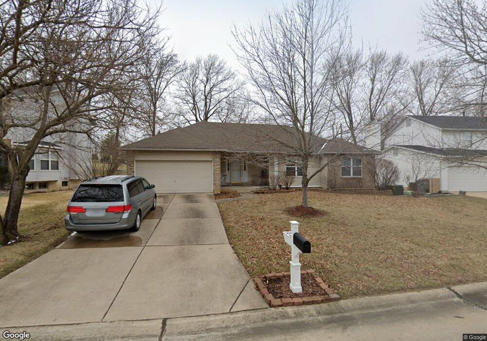
624 Bennington Dr Saint Charles, MO 63304
Estimated Value: $366,000 - $386,000
3
Beds
2
Baths
1,692
Sq Ft
$220/Sq Ft
Est. Value
About This Home
This home is located at 624 Bennington Dr, Saint Charles, MO 63304 and is currently estimated at $372,650, approximately $220 per square foot. 624 Bennington Dr is a home located in St. Charles County with nearby schools including John Weldon Elementary School, Francis Howell Middle School, and Francis Howell Union High School.
Ownership History
Date
Name
Owned For
Owner Type
Purchase Details
Closed on
Mar 23, 2016
Sold by
Davis Jack R and Davis Judy E
Bought by
Davis Jack R and Davis Judy E
Current Estimated Value
Purchase Details
Closed on
Jul 25, 1997
Sold by
Villhard Robert L Michelle R
Bought by
Davis Jack R and Davis Judy E
Home Financials for this Owner
Home Financials are based on the most recent Mortgage that was taken out on this home.
Original Mortgage
$67,900
Outstanding Balance
$9,817
Interest Rate
7.6%
Estimated Equity
$362,833
Create a Home Valuation Report for This Property
The Home Valuation Report is an in-depth analysis detailing your home's value as well as a comparison with similar homes in the area
Home Values in the Area
Average Home Value in this Area
Purchase History
| Date | Buyer | Sale Price | Title Company |
|---|---|---|---|
| Davis Jack R | -- | None Available | |
| Davis Jack R | $127,900 | -- |
Source: Public Records
Mortgage History
| Date | Status | Borrower | Loan Amount |
|---|---|---|---|
| Open | Davis Jack R | $67,900 |
Source: Public Records
Tax History Compared to Growth
Tax History
| Year | Tax Paid | Tax Assessment Tax Assessment Total Assessment is a certain percentage of the fair market value that is determined by local assessors to be the total taxable value of land and additions on the property. | Land | Improvement |
|---|---|---|---|---|
| 2025 | $3,819 | $66,521 | -- | -- |
| 2023 | $3,821 | $59,300 | $0 | $0 |
| 2022 | $3,405 | $49,040 | $0 | $0 |
| 2021 | $3,413 | $49,040 | $0 | $0 |
| 2020 | $3,201 | $44,594 | $0 | $0 |
| 2019 | $3,205 | $44,594 | $0 | $0 |
| 2018 | $2,844 | $37,731 | $0 | $0 |
| 2017 | $2,798 | $37,731 | $0 | $0 |
| 2016 | $2,533 | $32,918 | $0 | $0 |
| 2015 | $2,522 | $32,918 | $0 | $0 |
| 2014 | $2,556 | $32,614 | $0 | $0 |
Source: Public Records
Map
Nearby Homes
- 1184 Clydesdale Dr
- 1209 Crooked Creek Dr
- 471 Bellingham Ct
- 1218 Saddlemaker Dr
- Windsor Plan at Cottleville Trails - Heritage Collection
- Chesapeake Plan at Cottleville Trails - Heritage Collection
- Davenport Plan at Cottleville Trails - Heritage Collection
- Lancaster Plan at Cottleville Trails - Heritage Collection
- Braxton Plan at Cottleville Trails - Heritage Collection
- Bridgeport Plan at Cottleville Trails - Heritage Collection
- Portsmouth Plan at Cottleville Trails - Heritage Collection
- Sierra Plan at Cottleville Trails - Heritage Collection
- Sierra – Universal Design – Plan at Cottleville Trails - Heritage Collection
- Rosemont Plan at Cottleville Trails - Heritage Collection
- Pierce Plan at Cottleville Trails - Heritage Collection
- 1361 Briar Creek Dr
- 1000 Santiago Trail
- 1004 Santiago Trail
- 9113 Camino Trail
- 2310 Federalist Place
- 622 Bennington Dr
- 626 Bennington Dr
- 620 Bennington Dr
- 628 Bennington Dr
- 700 Crooked Lake Ct
- 629 Bennington Dr
- 701 Crooked Lake Ct
- 618 Bennington Dr
- 317 Willowpointe Dr
- 631 Bennington Dr
- 702 Crooked Lake Ct
- 319 Willowpointe Dr
- 703 Crooked Lake Ct
- 619 Bennington Dr
- 632 Bennington Dr
- 616 Bennington Dr
- 633 Bennington Dr
- 704 Crooked Lake Ct
- 321 Willowpointe Dr
- 705 Crooked Lake Ct