Estimated Value: $283,000 - $341,421
3
Beds
2
Baths
2,313
Sq Ft
$136/Sq Ft
Est. Value
About This Home
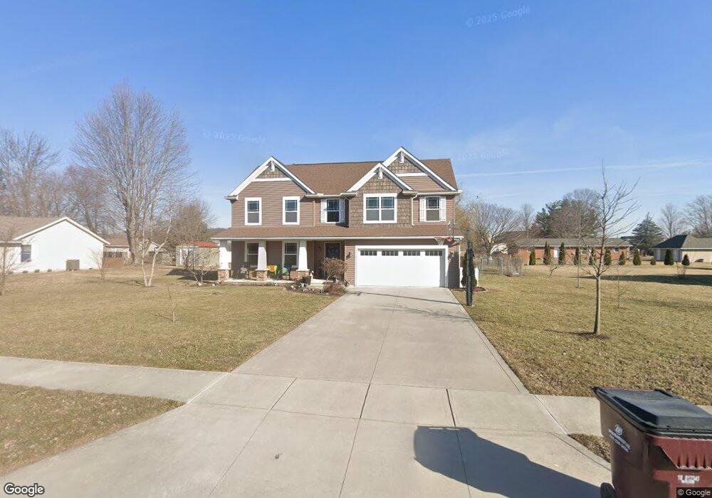
This home is located at 624 Clint Dr, Ada, OH 45810 and is currently estimated at $313,855, approximately $135 per square foot. 624 Clint Dr is a home located in Hardin County with nearby schools including Ada Elementary School and Ada High School.
Ownership History
Date
Name
Owned For
Owner Type
Purchase Details
Closed on
May 31, 2012
Sold by
Simon Properties Llc
Bought by
Donley Dustin N and Donley Jennifer K
Current Estimated Value
Purchase Details
Closed on
Aug 30, 2010
Sold by
Simon Properties Llc and Simon John P
Bought by
Stoner William D and Stoner Jill M
Purchase Details
Closed on
Apr 27, 2004
Bought by
Simon Properties Llc
Create a Home Valuation Report for This Property
The Home Valuation Report is an in-depth analysis detailing your home's value as well as a comparison with similar homes in the area
Home Values in the Area
Average Home Value in this Area
Purchase History
| Date | Buyer | Sale Price | Title Company |
|---|---|---|---|
| Donley Dustin N | $20,000 | None Available | |
| Stoner William D | $21,000 | -- | |
| Simon Properties Llc | -- | -- |
Source: Public Records
Tax History
| Year | Tax Paid | Tax Assessment Tax Assessment Total Assessment is a certain percentage of the fair market value that is determined by local assessors to be the total taxable value of land and additions on the property. | Land | Improvement |
|---|---|---|---|---|
| 2024 | $3,842 | $99,080 | $8,860 | $90,220 |
| 2023 | $3,819 | $99,080 | $8,860 | $90,220 |
| 2022 | $3,428 | $77,730 | $8,450 | $69,280 |
| 2021 | $3,761 | $77,730 | $8,450 | $69,280 |
| 2020 | $3,813 | $77,730 | $8,450 | $69,280 |
| 2019 | $3,543 | $73,070 | $8,050 | $65,020 |
| 2018 | $3,465 | $73,070 | $8,050 | $65,020 |
| 2017 | $1,706 | $73,070 | $8,050 | $65,020 |
| 2016 | $2,947 | $66,970 | $4,550 | $62,420 |
| 2015 | $2,850 | $66,970 | $4,550 | $62,420 |
| 2014 | $1,450 | $66,970 | $4,550 | $62,420 |
| 2013 | $1,436 | $62,940 | $4,550 | $58,390 |
Source: Public Records
Map
Nearby Homes
- 820 S Main St
- 710 S Main St
- 318 Willeke Ave
- 314 E University Ave
- 308-310 S Simon St
- 210 N Gilbert St
- 211 S Main St
- 602 Conley Ave
- 327 W North Ave
- 442 Edwards St
- 128 W North Ave
- 629 N Main St
- 503 E North Ave
- 724 N Main St
- 746 N Main St Unit 61
- 746 N Main St Unit 63
- 746 N Main St Unit 74
- 746 N Main St Unit 9
- 746 N Main St Unit 35
- 746 N Main St Unit 5
- 622 Clint Dr
- 626 Clint Dr
- 627 Clint Dr
- XXX Clint Dr
- 613 Pleasantview St Unit 615
- 625 Clint Dr
- 621 Clint Dr
- 512 Clint Dr
- 619 Pleasantview St
- 623 Pleasantview St
- 517 Clint Dr
- 509 Pleasantview St Unit 511
- 1010 Southernview St
- 2002 Southernview St
- 620 Pleasantview St
- 626 Pleasantview St
- 627 Pleasantview St
- 508 Clint Dr
- 614 Pleasantview St
Your Personal Tour Guide
Ask me questions while you tour the home.