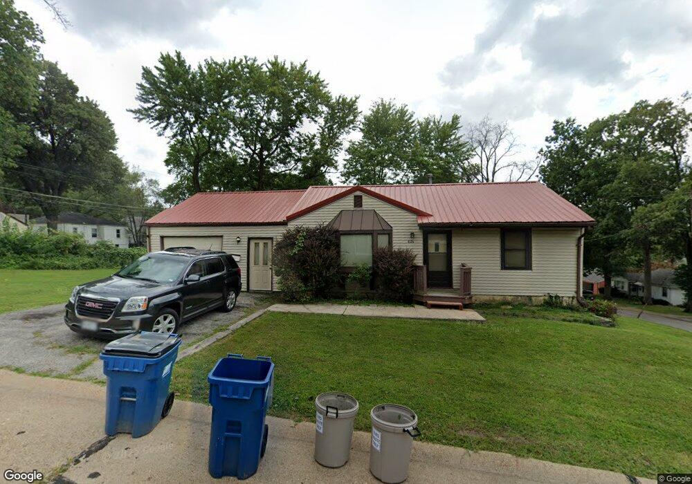
624 Laurel Ave Saint Louis, MO 63135
Estimated Value: $85,000 - $114,000
2
Beds
1
Bath
1,296
Sq Ft
$80/Sq Ft
Est. Value
About This Home
This home is located at 624 Laurel Ave, Saint Louis, MO 63135 and is currently estimated at $103,667, approximately $79 per square foot. 624 Laurel Ave is a home located in St. Louis County with nearby schools including Lee Hamilton Elementary School, Ferguson Middle School, and McCluer High School.
Ownership History
Date
Name
Owned For
Owner Type
Purchase Details
Closed on
Dec 15, 2022
Sold by
Ada Properties Llc
Bought by
Pch Plantmore Llc
Current Estimated Value
Purchase Details
Closed on
Jan 18, 2011
Sold by
Deutsche Bank National Trust Company
Bought by
Ada Properties Llc
Purchase Details
Closed on
Sep 23, 2010
Sold by
Guinan Thomas P
Bought by
Deutsche Bank National Trust Company
Purchase Details
Closed on
Nov 17, 1998
Sold by
Katherine Guinan
Bought by
Guinan Thomas P
Create a Home Valuation Report for This Property
The Home Valuation Report is an in-depth analysis detailing your home's value as well as a comparison with similar homes in the area
Home Values in the Area
Average Home Value in this Area
Purchase History
| Date | Buyer | Sale Price | Title Company |
|---|---|---|---|
| Pch Plantmore Llc | -- | Investors Title | |
| Ada Properties Llc | $13,000 | None Available | |
| Deutsche Bank National Trust Company | $43,467 | None Available | |
| Guinan Thomas P | -- | -- |
Source: Public Records
Tax History Compared to Growth
Tax History
| Year | Tax Paid | Tax Assessment Tax Assessment Total Assessment is a certain percentage of the fair market value that is determined by local assessors to be the total taxable value of land and additions on the property. | Land | Improvement |
|---|---|---|---|---|
| 2025 | $1,009 | $21,040 | $2,340 | $18,700 |
| 2024 | $1,009 | $13,760 | $1,560 | $12,200 |
| 2023 | $1,003 | $13,760 | $1,560 | $12,200 |
| 2022 | $1,021 | $12,210 | $2,600 | $9,610 |
| 2021 | $988 | $12,210 | $2,600 | $9,610 |
| 2020 | $1,082 | $12,050 | $2,720 | $9,330 |
| 2019 | $1,062 | $12,050 | $2,720 | $9,330 |
| 2018 | $896 | $9,030 | $2,360 | $6,670 |
| 2017 | $879 | $9,030 | $2,360 | $6,670 |
| 2016 | $847 | $8,550 | $1,980 | $6,570 |
| 2015 | $852 | $8,550 | $1,980 | $6,570 |
| 2014 | $862 | $8,550 | $2,220 | $6,330 |
Source: Public Records
Map
Nearby Homes
- 418 Millman Dr
- 406 Teston Dr
- 610 Superior Dr
- 324 Ames Place
- 310 Ames Place
- 405 Teston Dr
- 315 Coppinger Dr
- 539 Coppinger Dr
- 408 Coppinger Dr
- 208 Coppinger Dr
- 818 Robert Ave
- 514 La Motte Ln
- 429 N Clay Ave
- 506 Averill Ave
- 206 Thoroughman Ave
- 931 Thatcher Ave
- 941 N Elizabeth Ave
- 925 Dyerdown Ave
- 716 Nancy Place
- 111 Royal Ave
- 422 Ballman Ave
- 625 Laurel Ave
- 416 Ballman Ave
- 423 Superior Dr
- 506 Ballman Ave
- 419 Superior Dr
- 412 Ballman Ave
- 501 Superior Dr
- 415 Superior Dr
- 425 Ballman Ave
- 421 Ballman Ave
- 510 Ballman Ave
- 507 Superior Dr
- 501 Ballman Ave
- 417 Ballman Ave
- 411 Superior Dr
- 408 Ballman Ave
- 505 Ballman Ave
- 511 Superior Dr
- 413 Ballman Ave