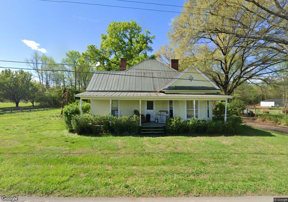
624 Liberty Rd SW Calhoun, GA 30701
Estimated Value: $674,000 - $815,000
5
Beds
4
Baths
2,393
Sq Ft
$306/Sq Ft
Est. Value
About This Home
This home is located at 624 Liberty Rd SW, Calhoun, GA 30701 and is currently estimated at $732,878, approximately $306 per square foot. 624 Liberty Rd SW is a home located in Gordon County with nearby schools including Swain Elementary School, Ashworth Middle School, and Gordon Central High School.
Ownership History
Date
Name
Owned For
Owner Type
Purchase Details
Closed on
Feb 7, 2011
Sold by
Goza John Raymond
Bought by
Goza John Raymond and Goza Elizabeth Ann
Current Estimated Value
Purchase Details
Closed on
May 4, 2007
Sold by
Monette Michael A
Bought by
Goza John Raymond
Purchase Details
Closed on
Jun 20, 2005
Sold by
Monette Mike
Bought by
Monette Michael A and Monette Marie J
Purchase Details
Closed on
May 4, 2005
Sold by
Monette Michael A and Monette Marie J
Bought by
Goza John Raymond
Purchase Details
Closed on
Dec 6, 2002
Sold by
White Wylie and White Donna
Bought by
Monette Mike
Purchase Details
Closed on
Jul 16, 2001
Sold by
Ables Nell
Bought by
White Wylie and White Donna
Purchase Details
Closed on
Feb 17, 1970
Bought by
Ables Nell
Create a Home Valuation Report for This Property
The Home Valuation Report is an in-depth analysis detailing your home's value as well as a comparison with similar homes in the area
Home Values in the Area
Average Home Value in this Area
Purchase History
| Date | Buyer | Sale Price | Title Company |
|---|---|---|---|
| Goza John Raymond | -- | -- | |
| Goza John Raymond | $429,900 | -- | |
| Monette Michael A | -- | -- | |
| Goza John Raymond | $429,900 | -- | |
| Monette Mike | $135,000 | -- | |
| White Wylie | $82,000 | -- | |
| Ables Nell | -- | -- |
Source: Public Records
Tax History Compared to Growth
Tax History
| Year | Tax Paid | Tax Assessment Tax Assessment Total Assessment is a certain percentage of the fair market value that is determined by local assessors to be the total taxable value of land and additions on the property. | Land | Improvement |
|---|---|---|---|---|
| 2024 | $3,608 | $207,120 | $46,720 | $160,400 |
| 2023 | $3,345 | $196,800 | $46,720 | $150,080 |
| 2022 | $3,268 | $186,440 | $46,720 | $139,720 |
| 2021 | $2,737 | $164,400 | $46,720 | $117,680 |
| 2020 | $2,818 | $165,520 | $46,720 | $118,800 |
| 2019 | $2,831 | $165,520 | $46,720 | $118,800 |
| 2018 | $2,571 | $156,480 | $46,720 | $109,760 |
| 2017 | $2,475 | $151,000 | $46,720 | $104,280 |
| 2016 | $4,485 | $151,000 | $46,720 | $104,280 |
| 2015 | $4,472 | $149,160 | $46,720 | $102,440 |
| 2014 | $4,230 | $145,256 | $46,723 | $98,533 |
Source: Public Records
Map
Nearby Homes
- 261 Liberty Ln SW
- 0 Reeves Station Rd SW Unit 10548197
- 0 Reeves Station Rd SW Unit 7601645
- 0 Highway 53 Spur SW Unit 7529096
- 490 McDaniel Station Rd SW
- 506 McDaniel Station Rd SW
- 458 McDaniel Station Rd SW
- 474 McDaniel Station Rd SW
- 121 Foxhall Dr SW
- 1943 Rome Rd SW
- 110 Darby Rd SW
- 00 Belmont Dr
- 301 Switch Rd SW
- 1401 U S 41
- 211 Darby Rd SW
- 130 Brookstone Dr SW
- 271 Old Belwood Rd SE
- 137 Regency Row SW
- 1311 Us Highway 41
- 0 W Belmont Dr Unit 10489910
- 716 Liberty Rd SW
- 696 Liberty Rd SW
- 664 Liberty Rd SW
- 706 Liberty Rd SW
- 590 Liberty Rd SW
- 744 Liberty Rd SW
- 502 Liberty Rd SW
- 766 Liberty Rd SW
- 735 Liberty Rd SW
- 930 Liberty Rd SW
- 509 Liberty Rd SW
- 15 Liberty Ln SW
- 631 Liberty Rd SW
- 109 Liberty Ln SW
- 519 Liberty Rd SW
- 477 Liberty Rd SW
- 571 Liberty Rd SW
- 946 Liberty Rd SW
- 108 Liberty Ln SW
- 119 Liberty Ln SW