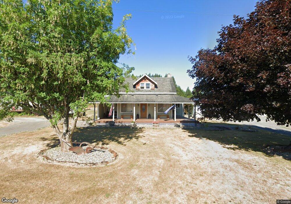
624 Mill Rd Chehalis, WA 98532
Estimated Value: $397,052 - $493,000
3
Beds
2
Baths
1,943
Sq Ft
$238/Sq Ft
Est. Value
About This Home
This home is located at 624 Mill Rd, Chehalis, WA 98532 and is currently estimated at $461,763, approximately $237 per square foot. 624 Mill Rd is a home located in Lewis County with nearby schools including Napavine Elementary School and Napavine Junior/Senior High School.
Ownership History
Date
Name
Owned For
Owner Type
Purchase Details
Closed on
Jan 22, 2021
Sold by
Cole Candice R and Cole Dakota Kenneth
Bought by
Cole Dakota K
Current Estimated Value
Home Financials for this Owner
Home Financials are based on the most recent Mortgage that was taken out on this home.
Original Mortgage
$234,000
Outstanding Balance
$208,218
Interest Rate
2.67%
Mortgage Type
New Conventional
Estimated Equity
$253,545
Purchase Details
Closed on
Feb 1, 2017
Sold by
Baker Kristy K
Bought by
Cole Dakota Kenneth
Home Financials for this Owner
Home Financials are based on the most recent Mortgage that was taken out on this home.
Original Mortgage
$204,250
Interest Rate
4.3%
Mortgage Type
New Conventional
Purchase Details
Closed on
Jan 21, 2005
Sold by
Sullivan Warren C
Bought by
Baker Everett W and Baker Kristy K
Home Financials for this Owner
Home Financials are based on the most recent Mortgage that was taken out on this home.
Original Mortgage
$167,810
Interest Rate
5.74%
Mortgage Type
Purchase Money Mortgage
Create a Home Valuation Report for This Property
The Home Valuation Report is an in-depth analysis detailing your home's value as well as a comparison with similar homes in the area
Purchase History
| Date | Buyer | Sale Price | Title Company |
|---|---|---|---|
| Cole Dakota K | -- | Lewis County Title | |
| Cole Dakota Kenneth | $215,000 | Title Guaranty | |
| Baker Everett W | -- | None Available |
Source: Public Records
Mortgage History
| Date | Status | Borrower | Loan Amount |
|---|---|---|---|
| Open | Cole Dakota K | $234,000 | |
| Closed | Cole Dakota Kenneth | $204,250 | |
| Previous Owner | Baker Everett W | $167,810 |
Source: Public Records
Tax History Compared to Growth
Tax History
| Year | Tax Paid | Tax Assessment Tax Assessment Total Assessment is a certain percentage of the fair market value that is determined by local assessors to be the total taxable value of land and additions on the property. | Land | Improvement |
|---|---|---|---|---|
| 2024 | $3,844 | $510,700 | $111,500 | $399,200 |
| 2023 | $3,515 | $502,100 | $98,300 | $403,800 |
| 2022 | $3,152 | $398,800 | $68,800 | $330,000 |
| 2021 | $2,964 | $398,800 | $68,800 | $330,000 |
| 2020 | $2,909 | $342,500 | $61,900 | $280,600 |
| 2019 | $2,291 | $314,300 | $55,100 | $259,200 |
| 2018 | $2,402 | $243,400 | $53,400 | $190,000 |
| 2017 | $2,273 | $224,800 | $53,400 | $171,400 |
Source: Public Records
Map
Nearby Homes
- 0 Koontz Rd
- 441 Stadium Loop
- 254 Parkside Loop
- 212 E Jefferson St
- 423 3rd Ave NW
- 815 1st Ave NE
- 1962 Old Highway 603
- 203 E Parkwood Ct
- 110 Cedar Crest Place
- 238 Mitchell Ln
- 299 Conrad Rd
- 213 Sommerville Rd
- 523 Haywire Rd
- 107 W Avery Rd Unit A & B
- 457 Antrim Rd
- 205 Antrim Rd
- 112 Topaz Ct
- 450 Hawkins Rd
- 126 Bethany Ln
- 151 Coulson Rd