Estimated Value: $56,000 - $77,000
2
Beds
1
Bath
624
Sq Ft
$103/Sq Ft
Est. Value
About This Home
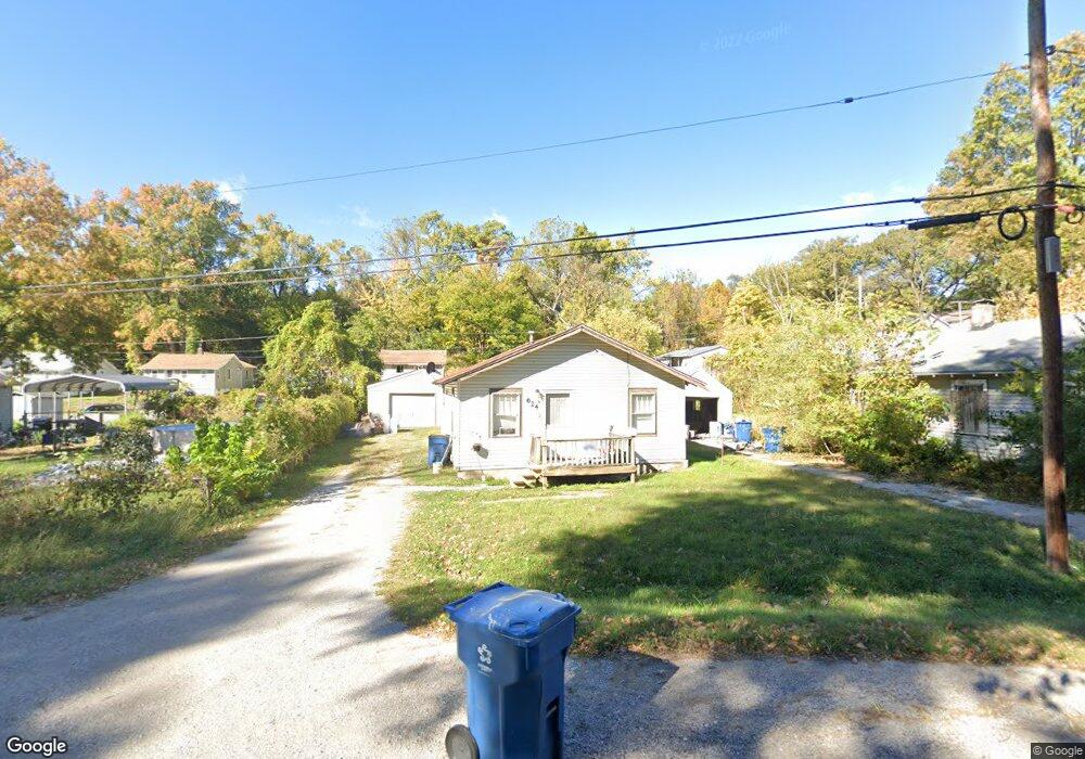
This home is located at 624 Olmstead Way, Alton, IL 62002 and is currently estimated at $64,043, approximately $102 per square foot. 624 Olmstead Way is a home located in Madison County with nearby schools including West Elementary School, Alton Middle School, and Alton High School.
Ownership History
Date
Name
Owned For
Owner Type
Purchase Details
Closed on
Jun 19, 2014
Sold by
Ufert Tammy and Northcut James
Bought by
Kopp James M and Kopp Mary
Current Estimated Value
Purchase Details
Closed on
Feb 6, 2003
Sold by
Pope Gregory G and Pope Karen K
Bought by
Ufert Tammy and Northcutt James
Home Financials for this Owner
Home Financials are based on the most recent Mortgage that was taken out on this home.
Original Mortgage
$21,750
Interest Rate
5.94%
Mortgage Type
Purchase Money Mortgage
Create a Home Valuation Report for This Property
The Home Valuation Report is an in-depth analysis detailing your home's value as well as a comparison with similar homes in the area
Home Values in the Area
Average Home Value in this Area
Purchase History
| Date | Buyer | Sale Price | Title Company |
|---|---|---|---|
| Kopp James M | $15,000 | None Available | |
| Ufert Tammy | $23,000 | -- |
Source: Public Records
Mortgage History
| Date | Status | Borrower | Loan Amount |
|---|---|---|---|
| Previous Owner | Ufert Tammy | $21,750 |
Source: Public Records
Tax History Compared to Growth
Tax History
| Year | Tax Paid | Tax Assessment Tax Assessment Total Assessment is a certain percentage of the fair market value that is determined by local assessors to be the total taxable value of land and additions on the property. | Land | Improvement |
|---|---|---|---|---|
| 2024 | $1,041 | $12,800 | $1,490 | $11,310 |
| 2023 | $1,041 | $11,560 | $1,350 | $10,210 |
| 2022 | $978 | $10,450 | $1,220 | $9,230 |
| 2021 | $900 | $9,820 | $1,150 | $8,670 |
| 2020 | $879 | $9,470 | $1,110 | $8,360 |
| 2019 | $908 | $9,250 | $1,080 | $8,170 |
| 2018 | $884 | $9,010 | $1,050 | $7,960 |
| 2017 | $872 | $9,010 | $1,050 | $7,960 |
| 2016 | $854 | $9,010 | $1,050 | $7,960 |
| 2015 | $285 | $9,010 | $1,050 | $7,960 |
| 2014 | $285 | $9,010 | $1,050 | $7,960 |
| 2013 | $285 | $9,260 | $1,080 | $8,180 |
Source: Public Records
Map
Nearby Homes
- 620 Sheppard St
- 609 Marsh Ave
- 2828 Residence St
- 2975 Shady Place
- 2933 Forest Dr
- 809 Maurice St
- 3407 Lincoln St
- 3006 Watalee St
- 2638 Sanford Ave
- 3410 Bolivar St
- 200 Sering Ave
- 2701 Watalee St
- 2901 Fernwood Ave
- 3013 Mayfield Ave
- 1201 Milton Rd
- 1215 Clawson St
- 2510 Denny Ave
- 2441 Sanford Ave
- 515 Lampert St
- 1220 Main St
- 626 Olmstead Way
- 620 Olmstead Way
- 622 Sheppard St
- 631 Olmstead Way
- 624 Sheppard St
- 616 Olmstead Way
- 613 Olmstead Way
- 628 Sheppard St
- 618 Sheppard St
- 611 Olmstead Way
- 3103 Hillcrest Ave
- 637 Olmstead Way
- 3105 Hillcrest Ave
- 614 Sheppard St
- 3107 Hillcrest Ave
- 630 Sheppard St
- 630 Sheppard St
- 609 Brookside Ave
- 611 Brookside Ave
- 615 Brookside Ave