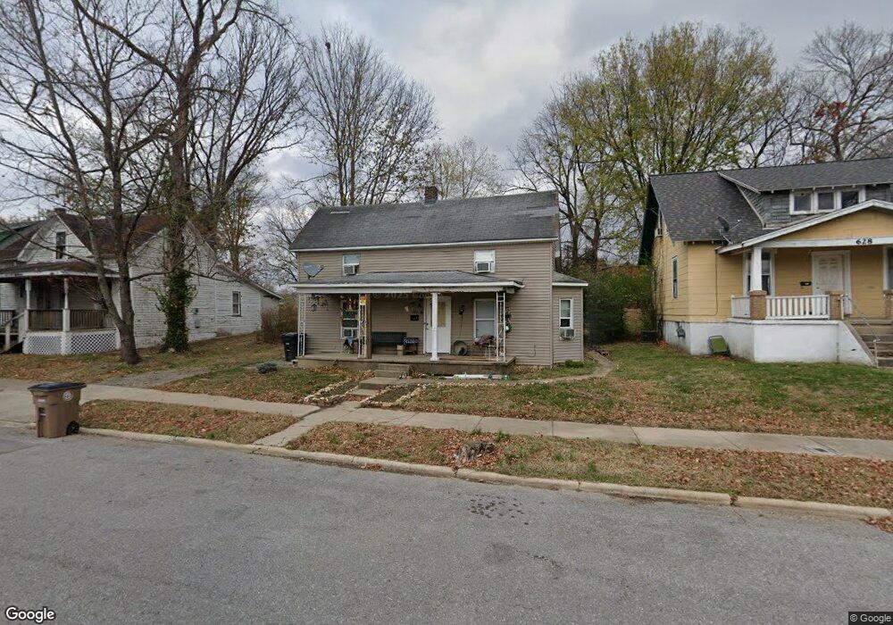
624 S Pacific St Cape Girardeau, MO 63703
Estimated Value: $34,194 - $111,000
3
Beds
2
Baths
1,550
Sq Ft
$43/Sq Ft
Est. Value
About This Home
This home is located at 624 S Pacific St, Cape Girardeau, MO 63703 and is currently estimated at $66,065, approximately $42 per square foot. 624 S Pacific St is a home located in Cape Girardeau County with nearby schools including Jefferson Elementary School, Central Junior High School, and Central Middle School.
Ownership History
Date
Name
Owned For
Owner Type
Purchase Details
Closed on
Mar 2, 2021
Sold by
Orange Reo Ii Llc
Bought by
Nationwide Community Revitalization Llc
Current Estimated Value
Purchase Details
Closed on
Feb 15, 2017
Sold by
Harbor Portfolio Vi Lp
Bought by
Orange Reo Ii Llc
Purchase Details
Closed on
Mar 1, 2013
Sold by
Harbour Portfolio Vi Lp
Bought by
Reeds Abigail R
Purchase Details
Closed on
May 10, 2011
Sold by
Fannie Mae
Bought by
Harbour Portfiio Vi Lp
Purchase Details
Closed on
Dec 15, 2010
Sold by
Yancey Travis and Yancey Patricia
Bought by
Federalnational Mortgage Assn
Create a Home Valuation Report for This Property
The Home Valuation Report is an in-depth analysis detailing your home's value as well as a comparison with similar homes in the area
Home Values in the Area
Average Home Value in this Area
Purchase History
| Date | Buyer | Sale Price | Title Company |
|---|---|---|---|
| Nationwide Community Revitalization Llc | $10,002 | None Available | |
| Orange Reo Ii Llc | $1,500 | -- | |
| Reeds Abigail R | -- | None Available | |
| Harbour Portfiio Vi Lp | -- | None Available | |
| Federalnational Mortgage Assn | $44,454 | None Available |
Source: Public Records
Tax History Compared to Growth
Tax History
| Year | Tax Paid | Tax Assessment Tax Assessment Total Assessment is a certain percentage of the fair market value that is determined by local assessors to be the total taxable value of land and additions on the property. | Land | Improvement |
|---|---|---|---|---|
| 2025 | $7 | $13,940 | $780 | $13,160 |
| 2024 | $7 | $13,270 | $740 | $12,530 |
| 2023 | $690 | $13,270 | $740 | $12,530 |
| 2022 | $636 | $12,240 | $690 | $11,550 |
| 2021 | $636 | $12,240 | $690 | $11,550 |
| 2020 | $638 | $12,240 | $690 | $11,550 |
| 2019 | $637 | $12,240 | $0 | $0 |
| 2018 | $636 | $12,240 | $0 | $0 |
| 2017 | $1,439 | $12,240 | $0 | $0 |
| 2016 | $635 | $12,240 | $0 | $0 |
| 2015 | $636 | $12,240 | $0 | $0 |
| 2014 | $639 | $12,240 | $0 | $0 |
Source: Public Records
Map
Nearby Homes
- 700 S Ellis St
- 541 S Ellis St
- 730 S Ellis St
- 631 S Benton St
- 701 S Benton St
- 811 Elm St
- 1102 College St
- 914 S Sprigg St
- 530 S Frederick St Unit REAR
- 1211 College St
- 539 Asher St
- 327 S Hanover St
- 1110 Ranney Ave
- 1317 Bloomfield Rd
- 431 S West End Blvd
- 926 William St
- 128 S Pacific St
- 1114 William St
- 427 S Louisiana St
- 309 S Spanish St
- 620 S Pacific St
- 628 S Pacific St
- 616 S Pacific St
- 614 S Pacific St
- 623 S Ellis St
- 825 Maple St
- 807 Maple St
- 627 S Pacific St
- 621 S Ellis St
- 617 S Ellis St
- 629 S Pacific St
- 823 Maple St
- 617 S Pacific St
- 611 S Ellis St
- 615 S Pacific St
- 703 S Ellis St
- 915 Maple St
- 705 S Pacific St
- 709 S Ellis St
- 712 S Pacific St